Proposal:Grade1-5
|
The proposal grade1-5 was built without a vote and the tagging is widely established based on this proposal. The Feature Page for the proposal grade1-5 is located at Key:tracktype. |
| grade1-5 | |
|---|---|
| Proposal status: | Inactive (inactive) |
| Proposed by: | Ben |
| Tagging: | tracktype=grade1-5 |
| Applies to: | |
| Definition: | classification (different grades) of track |
| Rendered as: | Same as unclassified roads, with varied shades of grey for the border lines |
| Draft started: | |
| Proposed on: | 2007-07-14 |
The key and values proposed here have already been included in Map Features on grounds of widespread use (over 80 thousand uses).
tracktype
Description
All the tracks are currently all the same. Therefore nearly everything I add is just called track. I think this is very vage, so I am proposing there is different grades of track. I have tagged a lot of my tracks in the following way, so am seeing if this can become standadised...
- tracktype - Grade 1 - A track that is concreted or tarmacked, but is laid and paid for by the landowners usually. Unless it is a bridleway or path, it would be private. Therefore they are different from unclassified. They are usually the main driveways to farms
- tracktype - Grade 2 - A track that is heavily used, and has stones/gravel
- tracktype - Grade 3 - A track that can have small amounts of stone or gravel, and still usually has hedging either side, but is often not used by the common car.
- tracktype - Grade 4 - A track that has no, or little, hardcore, but is used semi-regually. Often muddy, and can still commonly have border hedges.
- tracktype - Grade 5 - A track that usually runs freely withough hedges and just grass. It is perminent and is clearly visible by the indented shape of the ground.
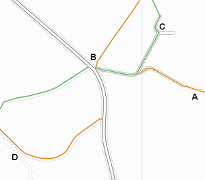
I propose that the tracks should appear the same as unclassified roads, being white with an outline, but the outline should be a fainter grey, the further down the list it is. This will then make the more visible tracks on a map, the more visible tracks in the field. Also in looking at the map, you will then pick out the stronger tracks to aim for.
I will try and get some images of examples of each track type to make it easier, but there is a huge difference between all these, and just calling them highway=track, is way too vage. Ben. 02:57, 29 Sept 2006 (BST) (Updated, 8th Novemeber)
Having a tracktype tag attached to something should be used instead of the highway=track tag. This way, highway=footway, for example, may be attached to the same way, and the footway will lay on top of the tracktype. The Highway tag should be used to define the legal access rights of a way, while the tracktype can define the physical properties of the way. Highway=track should be unneeded, although highway=unsurfaced may still be needed for ways that are open to traffic without being classified as a byway. Ben. 00:55, 8th Nov 2006 (DST)
Example
- A: A grade5 track with a highway tag ontop
- B: The unclassified road doesn't require the footway and bridleway to render ontop
- C: The Grade2 track does require the footway and bridleway to render ontop
- D: a grade5 track by iteself. A more subtle colour, as it is a more subtle track


