Proposal:Weir
Jump to navigation
Jump to search
| The Feature Page for the approved proposal Tag:waterway=weir is located at Tag:waterway=weir |
Weirs can already be identified as waterway=weir on a node along a waterway.
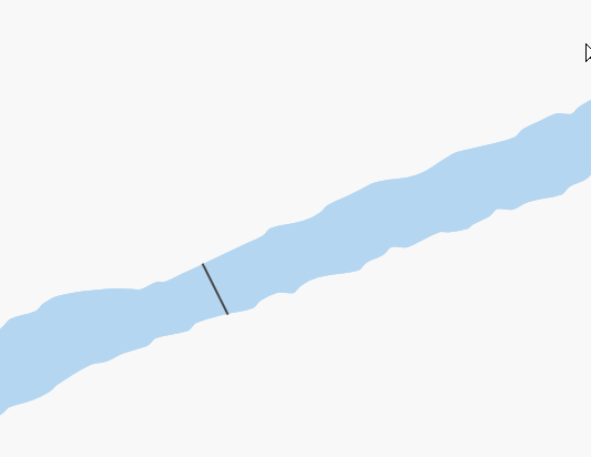
This proposal is specifically for and extension of waterway=weir to also be used as a linear feature (way) across a wide river drawn as an area (using waterway=riverbank or natural=water).
A Weir will be rendered as a thick gray line.
Also See
http://en.wikipedia.org/wiki/Weir
Please also see waterway=dam for a similiar feature for dam walls, but rendered as a thicker black line.
Comments=
- What's a weir? --Hawke 23:18, 11 June 2007 (BST)
- I've added a short description to the map features page entry - please edit if it's still incorrect Ulfl 02:31, 12 July 2007 (BST)
- This proposal sounds reasonable Ulfl 02:31, 12 July 2007 (BST)
- As you can see not all weirs are at right angles to the stream! [1] [2] On Navigable Waterways many are at junctions, some of them parallel. [3] How would these be dealt with - they are large 'landmark' type structures? On top of this many have publicly accessible footways over them.--Ricka 01:36, 9 October 2007 (BST)
- The rendering will just follow the line used to mark the weir, it does not have to be at right angles. Footways can be added on top of the weir.--Swampwallaby 02:13, 14 December 2007 (UTC)
- Specifically, it would be nice to be able to do waterway=weir, highway=footway on one linear way and have it rendered as a composite. MikeCollinson 08:38, 14 December 2007 (UTC)
- This seems to me a simple extension of the existing waterway=weir tag to cover lines as well as nodes. A yes as is from me. MikeCollinson 08:38, 14 December 2007 (UTC)
- Also good for me. Could the line has interruptions to clearly show where water flows ? Gummibaerli 01:37, 15 December 2007 (UTC)
- I don't quite follow. By definition, a weir has water flowing over all of it. If you have a structure that is part dam and part weir, then you can just tag the different sections as such. If there is a gap, then don't draw the weir there. --Swampwallaby 10:09, 15 December 2007 (UTC)
- For small weir and river, yes. But a weir is/was generaly feeding a canal with either a water mill, an hydroelectric plant or the like. Most of them have a way to control the water level in the canal. So except during flooding, not much water flow throug them. It's not a dam either, because it's alight structure and all elements composing the weir can be removed to allow more water to pass (see [Weir], nice examples). But OK, my remark was stupid Gummibaerli 20:22, 15 December 2007 (UTC)
- Great there is a big road bridge in Durham that if your on the left you will see the weir is parrell to the embankment, but if your on the right of the bridge you will see that the weir has curved round and is at a right angle to the embankment. Being able to draw a line would help you understand where you were in relation to the weir. - LastGrape 19:54, 15 December 2007 (UTC)
Voting
- Voting commenced 28th December 2007
- I Approve this proposal. --Swampwallaby 11:28, 28 December 2007 (UTC)
- I approve this proposal. --Eimai 12:26, 28 December 2007 (UTC)
- I approve this proposal. -- Franc 13:24, 28 December 2007 (UTC)
- I approve this proposal. -- MichaelK 13:24, 28 December 2007 (UTC)
- I approve this proposal. -- Robx 15:12, 28 December 2007 (UTC)
- I approve this proposal. -- MikeCollinson 15:47, 28 December 2007 (UTC)
- I Approve this proposal. -- Myfanwy 03:03, 29 December 2007 (UTC)
- I Approve this proposal. -- Cohort 03:52, 29 December 2007 (UTC)
- I approve this proposal--Walley 22:09, 29 December 2007 (UTC)
- I approve this proposal -- Ulfl 12:30, 31 December 2007 (UTC)
- I approve this proposal --Gummibaerli 23:39, 3 January 2008 (UTC)
Voting closed, feature approved. -- Ulfl 07:39, 9 January 2008 (UTC)
