TIGER fixup/Alignment
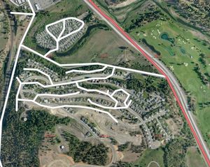
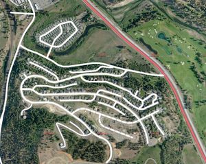
The key to fixing up TIGER alignment is to realise that the roads are there and generally connected properly - they are just in the wrong place and the curves are probably out of alignment. Have a look at this animation on Vimeo:
TIGER alignment animation on Vimeo
 |
 Watch the animation on Vimeo |
The way to go about this is to look for distinctive features, and slowly move things around until they are in the right place. In this example a good place to start is the figure of eight at the top of the screen - it's fairly easy to see where the roads are meant to go, and which one is which. When they have been aligned, the next estate can be tackled. Finally, new roads that have been built in this estate after TIGER was created have been added, and the area is complete! Now a ground survey is needed to check that all the roads have the correct names, but that's probably easier to do now that the layout will be correct on a GPS.
Be careful when doing this, since we don't want to destroy anything. But with a bit of practice figuring things out becomes much easier. Have a look for junctions, road ends, unusual features or manageable areas like the above. Take your time and do it right!
Straight roads
Many cities have a grid-like street system, where perfectly straight streets divide the city into blocks. But the TIGER lines for these streets are often far from straight.
You can use your editor to automatically straighten the road.
In Potlatch, select a road that should be straight. Using the Bing aerial imagery, move the start and end points to the right place. Then press 'T', or click the Tidy icon. The road will be straightened and any surplus nodes removed.
If a road is straight but with a curve at one end, you can split it into two ways before the curve, then just straighten one way.
Accuracy of bing aerial imagery
In some areas, bing is offset from reality. In general this is not worth worrying about. The vast majority of the U.S. is just inaccurate due to TIGER data inaccuracies, and you should feel free to get on with fixing this up using Bing imagery. However, if you're in an area where others have been working on the map, bear in mind that other people may have attempted to correct for an offset. See bing#Precision. Mostly it's not worth worrying about though.
Problem counties
The following counties are known to have widespread alignment problems and require extensive work throughout:
- Monroe County, FL (mostly clean)
- Orange County, FL (mostly clean)
- Osceola County, FL
- Sussex County, NJ (Mostly clean)
- Rockland County, NY
- Montgomery County, PA
- Lebanon County, PA
- Dauphin County, PA (mostly clean)
- York County, PA
- Columbiana County, OH
- Cherokee County, North Carolina
- Fannin County, GA
- Lane County, Oregon