TIGER


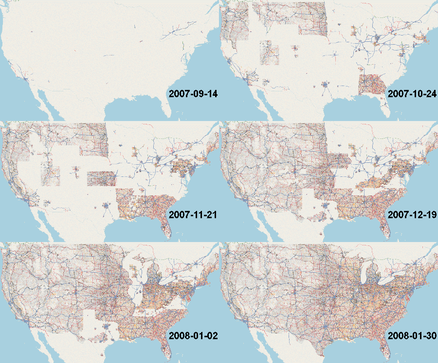
The Topologically Integrated Geographic Encoding and Referencing system (TIGER) data, produced by the US Census Bureau, is a public domain data source which has many geographic features. The TIGER/Line files are extracts of selected geographic information, including roads, boundaries, and hydrography features. All of the roads were imported into OSM in 2007 and 2008, populating the nearly empty map of the United States.
However, while the import helped kickstart OSM data in the US, it also brought a plethora of problems with data inaccuracy, some of which persist to this day. Lots of cleanup has been done from the initial import. The TIGER fixup page lists things to look for when fixing TIGER data.
Status
It is unlikely that the TIGER data ever will be imported again. Enough editing has occurred since the original upload of the TIGER 2005 data (which was not uploaded until 2007) that it will be difficult to determine if differences between future TIGER and OSM are because of good corrections made by OSM editors or from bad TIGER data. With the US mapping community growing strongly now, it isn't as much of a concern. Do not worry about getting your work overwritten by new TIGER data. Go map!
However, TIGER may be useful for analyzing differences with OSM, and for partial import and merging using tools such as JOSM. Please visit the page for the latest #Updates of TIGER data for more information.
Lots of cleanup remains to be done from the initial import. The TIGER fixup page lists things to look for when fixing TIGER data.
History
An import of the 2005 TIGER/Line data was completed in 2007. This was featured in a Linux.com article from January 23, 2008, titled "OpenStreetMap project completes import of United States TIGER data".
An initial run took place in 2005, but unfortunately had to be shut off, and data purged, in November 2006 due to data integrity problems. See Old TIGER Import 2005/2006 for more information. A second, successful import followed a different philosophy, and began in September 2007 using a new Ruby-based TIGER conversion script. Here is a post (Wayback Machine) describing this import in more detail. Also see the TIGER 2005 page.
Updates
The Census Bureau releases updated TIGER data annually. For automatically updated TIGER data check out TIGERweb. Check the following pages for OpenStreetMap notes regarding specific TIGER releases:
- TIGER 2024
- TIGER 2023
- TIGER 2022
- TIGER 2021
- TIGER 2020
- TIGER 2019
- TIGER 2018
- TIGER 2017
- TIGER 2016
- TIGER 2015
- TIGER 2014
- TIGER 2012 - Tiles giving a yellow roads overlay, and TIGER Battlegrid were first developed with this dataset.
- TIGER 2011
- TIGER 2010
- TIGER 2009
- TIGER 2007
- TIGER 2005 - This dataset was used for the massive import of roads into OpenStreetMap.
See also
- TIGER fixup
- Old TIGER Import 2005/2006
- TIGER to OSM Attribute Map - attribute map used for data prior to 2007, when the switch was made to using MTFCC's instead of CFCC's
External links
- Main TIGER Website
- shapefiles (since 2007; 2006 and eariler available in ASCII)
- TIGER geodatabases (since 2013)
- US Census Bureau Website