Tag:amenity=hitching_post
 |
| Description |
|---|
| A post or rail for tethering a horse. |
| Group: amenities |
| Used on these elements |
| Useful combination |
|
| See also |
| Status: in use |
| Tools for this tag |
|
A hitching post or hitching rail is a piece of street furniture for tethering a horse. It may look like a short pole or a handrail or something more ornate. It can be thought of as a counterpart to amenity=bicycle_parking but for horses.
Where to find
Hitching posts are installed along the street or outside shops, especially in towns where horseback riding or horse-drawn carriages are common. For example, in areas with many Amish residents, every parking lot has a hitching post. In some cities, horse-drawn carriages are a popular tourist activity, so hitching posts are available at intervals along the street.
An area tagged as tourism=trail_riding_rest may have one or more hitching rails as well.
How to map
Add a node at the location of the hitching post. Alternatively, if it is a rail, draw a way from one end of the rail to the other.
If the hitching post has a name that isn't merely a description, use the name=* key. If the hitching post is for a shop's customers only, use the access=customers tag.
Examples

A wooden hitching rail in rural Montana
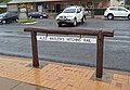
A wooden hitching rail in Queensland
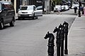
Hitching posts in New Orleans, where carriage rides are a popular tourist attraction
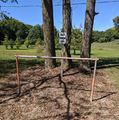
A metal hitching rail in Indiana's Amish Country
.jpg)


See also
- amenity=animal_hitch - A place where animals can be hitched or tied to
- carriage=* to identify facilities suitable for horse-and-buggy combinations
- barrier=handrail may look similar but serves a different purpose
- amenity=dog_parking for dogs