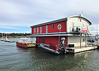
Tag:amenity=rescue_station
Jump to navigation
Jump to search
| Description |
|---|
| A rescue station (no fire brigade) or the administrative building of a rescue service. |
| Group: amenities |
| Used on these elements |
| Useful combination |
|
| See also |
| Status: in use |
| Tools for this tag |
|
A rescue station is a location where some rescue service is located. However, it is recommended to use a more specific tagging if available, namely amenity=fire_station for a fire department or emergency=ambulance_station for ambulance locations - see below for more examples.
How to map
Add a point to the center of the building rescue station and attach a tag amenity=rescue_station. You can give the name of the tag name=*.
Combinations
- building=* — mark the actual building rescue station
See also
- Emergency facilities and amenities
- emergency=lifeguard
- emergency=mountain_rescue
- office=government – a government offices, include rescue services
