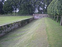
Tag:barrier=haha
 |
| Description |
|---|
| A recessed retaining wall with a grassy ditch on one side. |
| Group: barriers |
| Used on these elements |
| Useful combination |
| See also |
| Status: in use |
| Tools for this tag |
A haha or ha-ha barrier is a recessed retaining wall with sunken turf on one side. It typically consists of a wall faced by a deep ditch. On the land above the ditch, at a distance, the wall is invisible. Traditionally, they were designed to stop cattle or deer, without barrier visible from the residence/gardens.
Hahas can be a falling hazard for pedestrians, since the dropoff is sudden and relatively hidden from view. Mapping hahas can allow data consumers to alert pedestrians about this hazard.
Hahas are often found in large landscaping projects from a few centuries ago to the present day.
How to map them
Draw the retaining wall as a way and tag it barrier=haha. Reverse the way if necessary to ensure that the lower side is on the right side of the way.
If you know the height of the wall, add height=* (in metres unless otherwise specified). If you know what the wall is made of, add material=*.
If the wall is not recessed into the ground, use barrier=wall instead. If the wall is recessed into the ground but the lower side is level and does not slope downward toward the wall, use barrier=retaining_wall instead.
See also
barrier=retaining_wallplus a parallelbarrier=ditchorman_made=embankmentcan also be used to map this feature. These tags are much more common.- A UK National Trust article What is a ha-ha