Tag:building=townhall
Jump to navigation
Jump to search
_September_2015-1.jpg) |
| Description |
|---|
| A townhall building. |
| Rendering in OSM Carto |

|
| Group: buildings |
| Used on these elements |
| Useful combination |
|
| See also |
| Status: in use |
| Tools for this tag |
A townhall building is a building errected as a townhall. This refers only to the building and does not imply that it currently functions as townhall. You can use the tag also for former townhalls (e.g. when a new townhall was built or the administrative authority transferred to a different municipality). For the townhall function, make sure to add amenity=townhall. The tag may also be used for a townhall building referring to only a part of a city, rather than the whole city (if locally considered a townhall).
How to map
Add building=townhall to an existing building or create a new one.
Photo examples
-
 Vienna Townhall
 -
 Paris Townhall
 -
 Brussels Townhall
 -
 Los Angeles City Hall
 -
 Tübingen Townhall
 -
 Cesano Boscone Townhall
 -
 former Veccana Townhall
 -
 Vercelli Townhall
 -
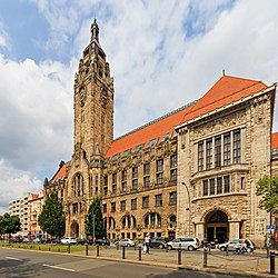 Berlin Charlottenburg Townhall
 -
 Puerto del Rosario Townhall
 -
 Kimberley City Hall
 -
 Laranjal Paulista Townhall
 -
 Berlin City Hall (Georgia)
 -
 Town hall back to the future


