Tag:building=bakehouse
Jump to navigation
Jump to search
 |
| Description |
|---|
| Building for baking bread. |
| Rendering in OSM Carto |

|
| Group: buildings |
| Used on these elements |
| Useful combination |
| See also |
| Status: approved |
| Tools for this tag |
The tag building=bakehouse is used to designate ![]() bakehouses (buildings for baking bread). It is often used with the tag
bakehouses (buildings for baking bread). It is often used with the tag amenity=baking_oven. It must not be used with shop=bakery.
Photos
-
 Bakehouse near Ulm/Germany
 -
 Bakehouse near Ulm/Germany
 -
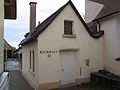
 Bakehouse from eastern France


Examples
Examples of possible combinations are detailed below:
Case 1: A bakehouse that you do not know if it still used:
Case 2: A bakehouse building that is still used:
- The "building" OSM object (way or multi-polygon relation):
- The "oven" OSM object (probably a node, eventually a way or a multi-polygon relation):
amenity=baking_ovenoven=wood_firedopening_hours=Sa 14:00-18:00; Su-Fr,PH off(time when it is possible to use the oven and only if it is different of the opening hours of the building)operator=Municipality of Anchorage
Case 3: Historic bakehouse; building still exists, oven still present but not used anymore (less than one time a year)
- The "building" OSM object (way or multi-polygon relation):
- The "oven" OSM object (probably a node, eventually a way or a multi-polygon relation):
Case 4: Historic bakehouse; building still exists, oven has been removed
Case 5: Historic bakehouse that has not been used for a long time and would need to be repaired before re-use:
- The "building" OSM object (way or multi-polygon relation):
- The "oven" OSM object (probably a node, eventually a way or a multi-polygon relation):
Rendering
Proposed: ![]()
See also
- The request for rendering on the standard map layer
amenity=baking_oven- the "baking oven" amenityoven=*- the type of oven power sourceshop=bakery- the shopman_made=kiln- almost never used for cooking (see https://en.wikipedia.org/wiki/List_of_ovens#Kilns)