Tag:bunker_type=bomb_shelter
Jump to navigation
Jump to search

 |
| Description |
|---|
| The bomb shelter are government-controlled places where people gather in case of bombing due to war. |
| Group: emergencies |
| Used on these elements |
| Requires |
| Status: in use |
| Tools for this tag |
|
It is an emergency temporary evacuation point of people when bombing is expected.
These are usually public buildings or facilities that are open to the public and are managed by the government. Some are built exclusively for use as bomb shelters, In these cases, civilian access is often restricted during peacetime.
Gallery
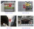
Various types of air defense facilities for emergency evacuation of civilians.(Seoul, South Korea)
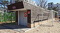
Civil defense dhelter of Anyang Elementary School.(Anyang, South Korea)

Civil defense bunker(Swiss)

Station of Kyiv Metro, converted into an air raid shelter after Russian invasion of Ukraine (2022)

.jpg)

Subkeys
- bunker:location=underground - Used where a feature is mainly under ground, may still be visible or accessible from the surface.
- bunker:location=overground - Used where a feature is mainly over ground. This includes tunnels in the ground.
Example

![]() On a node,
On a node, ![]() On a area :
On a area :