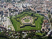
Tag:castle_type=citadel
Jump to navigation
Jump to search
| Description |
|---|
| The fortified centre of a city |
| Group: historic |
| Used on these elements |
| Requires |
| Useful combination |
|
| See also |
| Status: approved |
| Tools for this tag |
|
A ![]() citadel is a historic fortification inside a city that served as defensive core. It is often bastioned and may even feature defence in depth with ditches and glacis (see defensive_works=*).
citadel is a historic fortification inside a city that served as defensive core. It is often bastioned and may even feature defence in depth with ditches and glacis (see defensive_works=*).
How to map
Citadels should be mapped just as any other historic=castle: as a ![]() node at the centre or as an
node at the centre or as an ![]() area along the outlines.
area along the outlines.
Note that outworks are sometimes included in the outlines of citadels and other fortifications. As of 2022-11-02 there seems to be no consistency or documented guideline on whether they should be included or left out.
