Key:fortification_type
Jump to navigation
Jump to search
 |
| Description |
|---|
| To specify the type of a fortification |
| Group: historic |
| Used on these elements |
| Documented values: 8 |
| Requires |
| Useful combination |
|
| Status: de facto |
| Tools for this tag |
Tag fortification_type=* is used to specify the type of a fortification.
How to map
historic=archaeological_sitemandatoryarchaeological_site=fortificationmandatory- In many cases, the fortifications can be further differentiated, as in:
fortification_type=battery- Artillery battery - A group of cannon in a fixed fortification, for coastal or frontier defense.
fortification_type=hill_fort-Hill fort - mounds (incl. Burgwälle(de), Wallburgen(de), Ringwälle(de), castro(fr))fortification_type=limes-Roman Limesfortification_type=motte- A raised area of ground forming the base location for a castle.fortification_type=ring_ditch-Concentric circular ditches (rondel)fortification_type=ringfort-Ring fort - circular fortified settlements that were mostly built during the Early Middle Ages up to about the year 1000.fortification_type=pa-Pā - a New Zealand Maori pā. Pā commonly refers to fortified settlements with palisades and defensive terraces.fortification_type=sconce-Sconce - small protective fortification built from the late Middle Ages until the 19th centuryfortification_type=watchtower-Watchtower - Its primary use is military and from a turret in that it is usually a freestanding structure.fortification_type=earthworks-Earthworks (archaeology) - Artificial changes in land level, typically made from piles of artificially placed or sculpted rocks and soil.
Examples
-

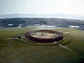
hill_fort -

limes -

sconce -
ring_ditch


Mapping mistakes
See also
historic=fortcastle_type=*defensive_works=*- an approved tagging scheme for defensive structures found in and around fortifications