Tag:fortification_type=motte
 |
| Description |
|---|
| A raised area of ground forming the base location for a castle. |
| Group: historic |
| Used on these elements |
| Requires |
| Useful combination |
| Status: in use |
| Tools for this tag |
A motte is a raised area of ground, a earthen platform, which had a castle built on top. The motte was "accompanied by a walled courtyard, or bailey, surrounded by a protective ditch and palisade"[1]. They were sometimes built on older structures like barrows or fortification_type=ringfort. When man made, the earth to form the motte came from the ditch dug around it.
Confusingly, in Ireland, they are mostly referred to in older maps and in the vernacular language as "moat", when a moat is defined as "a deep, broad ditch, either dry or filled with water, that is dug and surrounds a castle, fortification, building or town"[2].
How to map
Ideally, draw the area, or, if not discernible on aerial imagery, add a node with the following required tags:
If it is known to be built on top of an older structure, the appropriate tags can be added as well.
Additional tags
heritage=*wikipedia=*wikidata=*tourism=attractionpossibly as part of a larger relation containing buildings, ticket office, car park etchistoric:civilization=*historic:period=*start_date=*
Examples
-
 Schematics of a motte-and-bailey castle
 -
 The early medieval Slavic settlement and history park at Bärnau-Tachov with the motte in the foreground, reconstructed example in Germany
 -
 Clough's Motte and Bailey Castle, Co. Down, Northern Ireland
 -
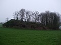
 Balmaclellan Motte, 13th century, Scotland
 -
 Motte and bailey 3, Le Mazeaubrun, Châlus, Haute-Vienne, France


Mapping mistakes
References
- ↑ Motte-and-bailey castle on Wikipedia
- ↑ Moat on Wikipedia