Tag:house=terraced
 |
| Description |
|---|
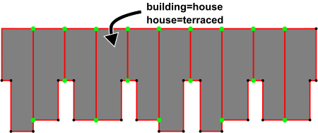
Used in addition to building=house to map the individual units in a terrace. Preferred over mapping the whole terrace as one building. |
| Group: buildings |
| Used on these elements |
| Requires |
| See also |
| Status: in use |
| Tools for this tag |
This tag can be used in addition to building=house to map the individual units in a row of houses that form a ![]() terrace.
These are known as "rowhouses" or "townhouses" in North American English.
terrace.
These are known as "rowhouses" or "townhouses" in North American English.
This is preferred over mapping the whole terrace as building=terrace by some mappers.
How to map
Draw an ![]() area for each unit in the terrace, ensuring they have at least two nodes connecting the units together.
area for each unit in the terrace, ensuring they have at least two nodes connecting the units together.
Alternate tagging
There are many ways of mapping terraces, these can be seen of the wiki page Tag:building=terrace.
The house=terrace tag is currently used identically to house=terraced by some, but is not the recommended form. Instead, house=terrace is recommended to be used only on the terrace as a whole — i.e. if the terrace has not been split into individually mapped houses.
See this OSM tag history as a curve chart which shows the development of the usage numbers of the different tags in comparison.
