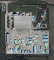
Tag:industrial=plastic_processing
Jump to navigation
Jump to search
 |
| Description |
|---|
| A factory which produces plastic products from purchased plastics |
| Group: industrial |
| Used on these elements |
| Requires |
| Useful combination |
| Status: in use |
| Tools for this tag |
Establishments primarily engaged in manufacturing plastic products from purchased plastics. Examples are bags, packaging, plastic foam, bottles and trash containers, specify the exact product using product=*.
How to map
Draw an area ![]() around the grounds of the plastic processing plant or place a node
around the grounds of the plastic processing plant or place a node ![]() at the centre of the grounds.
at the centre of the grounds.
Add
Examples
| Photo | Tagging | Note |
|---|---|---|

|
industrial=plastic_processingman_made=workslanduse=industrialname=Diamond Plasticoperator=Diamond Plastic Corporationproduct=pvc_pipes
|
A plastic pipe factory tagging example |