Tag:leisure=fox_covert
 |
| Description |
|---|
| A planted or natural area set aside as habitat for foxes used in fox hunting. |
| Group: leisure |
| Used on these elements |
| Requires |
| Useful combination |
|
|
| Status: in use |
| Tools for this tag |
A fox covert or fox cover (both pronounced like "cover") is/ was a wooded or scrubby area where foxes live until the annual fox hunt (see Fox hunting on Wikipedia). In Ireland, where fox hunt is still legal, many were planted in the 19th century and were recorded on early Ordnance Survey maps with the label "Fox Covert". Some are overgrown with gorse/ furze, and a name containing "Gorse" or "Spinney" (in England) can be found on old maps.
Currently in use fox coverts are managed by hunting societies aka hunts.
In areas of the UK where fox hunt has been made illegal, some former fox hunts have been turned into nature reserves[1].
"Fox covert" is also part of placenames such as house names, townlands[2][3], residential highways[4][5] and pubs[6][7]. Some locations might survive in field names.
How to map
Set node or draw area and add the tag leisure=fox_covert. Depending on the circumstances, map as landuse=forest, natural=wood or natural=scrub.
There are also cases where the fox covert is the inner area of a multipolygon forest relation.
You can add the operator=*, if you know which hunt manages the fox covert.
Former fox coverts
Lifecycle prefixes like was:, demolished:, disused: or historic: can be used to mark fox coverts which are no longer in use or where the landuse=* has changed.
If you are not sure whether they are still in use (because it requires a bit of research), you can map the forest/ wood/ scrub with a name=*=WHATEVER Fox Cover(t) or old_name=WHATEVER Fox Cover(t) and give the source of the old map you retrieved the information from.
Taginfo for variations of the main key
Gallery
-
 Foxton Fox Covert by Graham Scarborough, CC BY-SA 2.0, via Wikimedia Commons
 -
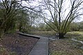 Walkway in Fox Covert by David Lally, CC BY-SA 2.0, via Wikimedia Commons
 -
 David Wright / Fox Covert Plantation
 -
 Fox Covert, stile and footpath by Michael Westley, CC BY-SA 2.0, via Wikimedia Commons
 -
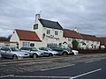 The Fox Covert pub by JThomas, CC BY-SA 2.0, via Wikimedia Commons


See also
You might find the following things in the vicinity to map:
barrier=horse_stileman made=mounting blockamenity=animal_breeding+animal=dog+animal_breeding=foxhounds+operator=*for foxhound kennelslanduse=farmland+name=*for field namesamenity=parking
Further reading
- Caroline Corballis: Hunting in County Kilkenny, Castlefield 1999, ISBN: 0953575004
References
- ↑ Fox Covert in North Hertfordshire
- ↑ Townland Foxcover name:ga=Clais an Rois in Co. Kilkenny
- ↑ Townland Foxcover, name:ga=Scairt an tSionnaigh in Co. Wexford
- ↑ Short residential street in Leatherhead, England
- ↑ Short residential street in Guilden Sutton near Chester, England
- ↑ Pub The Fox Covert in Yarm, UK
- ↑ Pub Fox Cover in North Seaton, UK