Tag:man_made=footwear_decontamination
 |
| Description |
|---|
| A facility to decontaminate footwear for hikers. |
| Group: man made |
| Used on these elements |
| Useful combination |
|
| Status: approved |
| Tools for this tag |
|
Indicates the presence of a footwear decontamination station.These are designed to reduce soil and other things e.g. plants, pathogens being carried on footwear of hikers. They are always beside or on a path. Many have big brushes (mounted facing up) to clean soil off footwear and a disinfectant applier for the base of the footwear.
These may be the only on the ground indication of contaminated areas or areas susceptible to contamination. People walking in these areas should go to these stations to prevent the spread of contamination.
How to map
Place a node ![]() or an area
or an area ![]() where the station is and then add the tag man_made=footwear_decontamination.
where the station is and then add the tag man_made=footwear_decontamination.
Tags used in combination
- operator=* The name of the company operating the station. Maybe helpful if there is a problem with the station to know who to contact.
Gallery
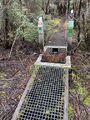
Phytophthora washdown station, Port Davey Track, Tasmania


Possible tagging mistakes
Not for door mats, shoe polishing stations etc.
Rendering
The sole of a boot/shoe with a scrubbing brush? It is unlikely this would be rendered except for hiking maps.
See also
- The Hiking page.
- The proposal page Proposed_features/man_made=footwear_decontamination.
- amenity=foot_shower - undocumented (but slightly used) possibly related tag