Tag:man_made=guard_stone
 |
| Description |
|---|
| A guard stone: a stone built onto or into the corner of a building or wall to prevent carriages from damaging the structure, often found on either side of an entrance to a laneway, or alongside a wall to protect it. |
| Group: man made |
| Used on these elements |
| Useful combination |
| See also |
| Status: approved |
| Tools for this tag |
The tag man_made=guard_stone is used for guard stones, also known as jostle stones. They were used in times of horse-drawn carriages to prevent carriages from damaging the wall, and to protect carriages from getting damaged. The majority are made from stone; some however are made of iron. Some of them bear survey markers such as benchmarks. They can be found on either side of a lane entrance or gateway. Sometimes, they are found in a row along a wall.
They are not to be confused with barrier=bollard, even though they might look similar, because guard stones do not prevent access (into a lane way).
How to tag
Add a node at the location (corner of a building, along a wall) and tag as man_made=guard_stone.
Additional tagging
Optional tags for guard stones are:
Examples
-
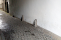 Guard stones protecting the wall of Chapel Lane in Kilkenny
 -
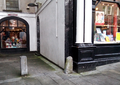 Guard stone (right) at the entrance to Pudding Lane, Kilkenny
 -
 Guard stone in Kilkenny with a benchmark (crowsfoot) on it
 -
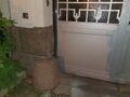 Example at a former printing house at Salomonstraße in Leipzig, Germany
 -
 Two guard stones at the entrance to Turmstraße 70, Berlin, Germany
 -
 Guard stones in Schlossstraße, Neustrelitz, Germany
 -
 Guard stones on Seestraße, Neustrelitz, Germany
 -
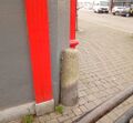
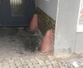
 Guard stone and bollard, Hoogstraat, Venlo


See Wikimedia for more examples from Northern Ireland, France, Belgium, Germany and other countries.
See also
External links
- Wikipedia page about guard stones German Wikipedia ("Radabweiser"/"Prellstein") French Wikipedia ("chasse-roue")
- Jostle stones in Co. Clare, Ireland
- "This is why that weird iron post on South Main Street exists" Example from Cork, Ireland
- Radio piece on German radio station NDR on guard stones ("Kratzsteine") (in German)
- "die Kurve kratzen" - a German saying relating to guard stones explained (in German)