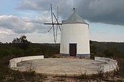
Tag:man_made=threshing_floor
 |
| Description |
|---|
| An open air paved area created to thresh the grain harvest and then winnow it. |
| Group: man made |
| Used on these elements |
| Useful combination |
| See also |
| Status: in use |
| Tools for this tag |
A ![]() Threshing floor is a specially flattened outdoor surface, usually circular and paved where a farmer would thresh the grain harvest and then winnow it. It can also exist inside a building with a smooth floor of earth, stone or wood.
Threshing floor is a specially flattened outdoor surface, usually circular and paved where a farmer would thresh the grain harvest and then winnow it. It can also exist inside a building with a smooth floor of earth, stone or wood.
Mostly historical or obsolete features, they're still used in many countries for their original purpose or repurposed for other activities like festivals, family events, other agricultural activities or even included in open air museums.
How to map
Set a node at the center of the feature or draw an area along its outline. Add the tag man_made=threshing_floor and name=* (if it has one).
If it is explicitly preserved as an historic site, like in a open air museum or tourism attraction, add the tag historic=yes and/or tourism=attraction. Don't use the historic=* tag for features that are simply old or disused.
Tags to use in combination
surface=*- the type of surface (paving_stones, concrete, stone, earth, etc.)access=*- the kind of access to the featurebarrier=*- to describe the type of barrier on its perimeter
See also
Examples
-
Algarve, Portugal
-
Santorini, Greece
-
Barranco do Velho, Portugal
-
Naxos, Greece
-
Folengranos, Greece
-
Ribeira de Algibre, Portugal


