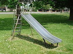
Tag:playground=slide
Jump to navigation
Jump to search
 |
| Description |
|---|
| A slide for children to play on in playgrounds. |
| Group: children |
| Used on these elements |
| Useful combination |
|
| See also |
| Status: approved |
| Tools for this tag |
The tag playground=slide describes a slide for children to play on in playgrounds. It should be tagged to separate objects within the area of a playground leisure=playground.
How to map
Use the tag playground=slide on a node or draw as an area along the structure outline.
Tags used in combination
playground:theme=*if the equipment has own theme (e.g.rocket)baby=yes/noif the equipment is primarily designed for babieswheelchair=yes/no/limitedif the equipment can be used by wheelchair userswalking_disability=yes/no/limitedsitting_disability=yes/no/limitedif the equipment can be used by those who cannot sitblind=yes/no/limitedname=*- of the equipment, not the play area.min_age=*- Minimum age of the user in yearsmax_age=*- Maximum age of the user in yearscentralkey=*- Where a key is required to access the equipmentmaterial=*-wood,steel,plastic, etc.
Playground area
To associate the playground area with the playground equipment, simply draw the playground as area and add the equipment as independent objects (nodes, ways or polygons) inside.