Tag:seamark:type=light_float
 |
| Description |
|---|
| A boat-like structure used instead of a light buoy. |
| Group: marine navigation |
| Used on these elements |
| See also |
| Status: de facto |
| Tools for this tag |
A boat-like structure used instead of a light buoy in waters where strong streams or currents are experienced, or when a greater elevation than that of a light buoy is necessary.
Use seamark:type=light_major for major navigational lights.
How to map
 Icon in OpenSeaMap
seamark:light_float:colour=*- colour of the boatseamark:light_float:colour_pattern=*seamark:topmark:shape=*seamark:topmark:colour=*seamark:name=*
Sectored light attributes
Note that sectored lights must bear a sector number (# = 1, 2, 3, ...) even if there is only one sector.
For more information on tagging sectored and directional lights, see: sectored and directional lights.
Example for each sector (# is a number):
seamark:light:#:categoryseamark:light:#:characterseamark:light:#:colourseamark:light:#:heightseamark:light:#:periodseamark:light:#:sequenceseamark:light:#:rangeseamark:light:#:sector_startseamark:light:#:sector_end
Light category
Category Beacon as upper, lower, directional
Light character
Rhythm of light
Light colour
seamark:light:1:colour=*seamark:light:1:colour=whiteseamark:light:1:colour=greenseamark:light:1:colour=red
Light group
The number of flashes, the combination of flashes or the Morse character(s) within one period of full sequence.
Light period
Time of the time occupied by an entire cycle of intervals of light and eclipse.
Light sequence
The sequence of times occupied by intervals of light and eclipse for all 'light characteristics' except for occulting where the sequence of times is occupied by intervals of eclipse and light.
Light range
The nominal range at which the light can be seen in nautical miles.
Light sector start
The sector limit 1 specifies the first limit of the sector. The order of sector limit 1 and sector limit 2 is clockwise around the light.
seamark:light:1:sector_start=*- in decimal degrees
Light sector end
The sector limit 2 specifies the second limit of the sector. The order of sector limit 1 and sector limit 2 is clockwise around the light.
seamark:light:1:sector_end=*- in decimal degrees
Light height
The vertical elevation of the actual lamp or light source (in meters) above the specified vertical datum (typically, mean sea level) – known as the focal height.
Light visibility
Shows the visibility of light.
Light exhibition
Shows what time the light is on.
This table is a wiki template with a default description in English. Editable here.
Example OpenSeaMap
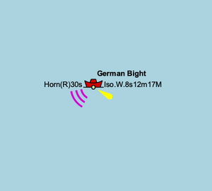
Click to open the map
See also
- Seamarks/Lights
- Lightvessel on Wikipedia