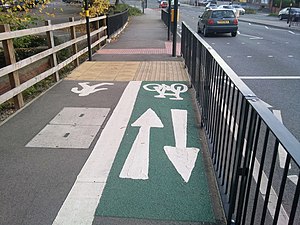
Tag:segregated=yes
Jump to navigation
Jump to search
| Description |
|---|
| For a cycleway or footway where there is a separation between the cyclists and the pedestrians. |
| Group: highways |
| Used on these elements |
| Useful combination |
| See also |
| Status: de facto |
| Tools for this tag |
|
Used to show that there is some form of segregation between pedestrians and cyclists on a cycle path or footway.

|

|

|
|---|
