Tag:survey_point:structure=block
Jump to navigation
Jump to search
 |
| Description |
|---|
| A solid block that sits on the ground, generally on a small concrete foundation. |
| Group: man made |
| Used on these elements |
| Requires |
| Status: approved |
| Tools for this tag |
Use survey_point:structure=block for a man-made block built into ground, with top of block often at ground level to approximately 0.5m from ground level.
See survey_point for more information about survey points. See survey_point:structure=* for other possible values.
Examples
-
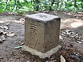 A block in Japan
 -
 Survey Point
