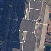
Tag:traffic_calming=choked_island
Jump to navigation
Jump to search
| Description |
|---|
| The combination of a pinch point and island as a single traffic calming feature. |
| Group: highways |
| Used on these elements |
| See also |
| Status: approved |
| Tools for this tag |
|
This tag page is a stub. You can help OpenStreetMap by expanding it.
Similar pages for structural reference: Tag:railway=tram, Tag:waterway=dock.
Similar pages for structural reference: Tag:railway=tram, Tag:waterway=dock.
The combination of a pinch point and island as a single traffic calming feature, common in Australia.
