Talk:Tag:waterway=weir
layer tag
I came across some weirs which had a layer=1- or layer=-2. Did not find any defined meaning of this combination? RicoZ (talk) 22:33, 30 October 2013 (UTC)
Direction of way
Is it really necessary to take care for the direction of the way, as suggested here: "Like a natural=cliff the line direction matters: On the left side there is the high side, on the right side is the lower side." IMHO we do not need this because the direction of the waterway is already indicating the high and low part, or am I missing something? --Dieterdreist (talk) 10:37, 21 February 2017 (UTC)
- In practice I many mappers got it, also in waterway=dam which could be considered somewhat analogous nothing like this is mentioned. But in theory I find it a good idea, a dam or weir is somewhat analogous to an embankment or waterfall and just because there is the theoretical possibility to get the information in some other way does not mean it should not be specified explicitly. Also linear weirs should be used in combination with water areas and there it is rather common that someone draws the water area but forgets the waterway and in this case you could use the explicit direction of the weir. RicoZ (talk) 22:12, 21 February 2017 (UTC)
Area?
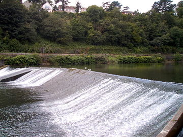
Why is this not valid on areas? A weir will also have an area as there is usually a slope on the low side. Makes it impossible to map weirs properly without it. --Gazer75 (talk) 15:10, 6 September 2020 (UTC)
Continuing Area comment and: top of weir to be marked
I agree Gazer75's suggestion might be useful. I came here to propose that the wiki advises that the way is placed at the top of the slope (the pictures currently on the page don't include such a weir, but this might do if the rights are ok). I also wonder if it's worth noting for aerial mappers that it's generally much easier to see the plunge pool (visible by the white water at the bottom of the slope) than the top of the weir. eteb3 (talk) 10:01, 26 September 2020 (UTC)
Highways over a weir
Unlike a dam, where the same structure is used as a highway surface and a barrier, weir is usually not related to the road at all: the barrier is in the water below whereas the road passes over a bridge above. Why not mention it in the wiki as a reason to map them with two separate ways? --Ungoose (talk) 14:30, 15 February 2021 (UTC)
- I agree that having 2 distinct objects for a weir would make sense (actually, for a dam it could make sense as well, the wall of the dam will usually be inclined and in map view appear as an area, bigger than the road that runs on the dam. Here is an example for a weir with a footway on a bridge above, already mapped as 2 objects: https://www.openstreetmap.org/way/170489633 --Dieterdreist (talk) 14:38, 15 February 2021 (UTC)
- +1 I think this is a sensible idea. You're right, these are two independent objects and any physical connection is incidental. eteb3 (talk) 16:38, 15 February 2021 (UTC)
- PS "Footway beneath"! (I assume you don't mean under the water ;-)
- Typo, I have fixed it, sorry. --Dieterdreist (talk) 21:25, 15 February 2021 (UTC)
- IMO they should be separated and each has different layers. They should never share the same segment. --CBRS (talk) 13:34, 12 May 2021 (UTC)
Movable weirs & other edits by Multimodaal
Hi @Multimodaal:
Thanks for your edits. I think they make some things clearer. I think they make some other things less clear and would appreciate your thoughts:
- Hi @Eteb3:
- Thanks for your constructive remarks, I just tried to make some improvements myself based on your thoughts, please find additional response below.
- Movable weirs are an important addition. I would argue we should first describe the 'normal' sort, then add movable weirs later as a special case.
- done (btw where I live in the polder below sea level we have many small weirs (hundreds) and here I believe most are adjustable
- Water may flow over the top
- The advantage of can is that it distinguishes a weir from a dam. Perhaps we could say can (at least sometimes), and then explain later about movable weirs.
- I fully agree that we must make the difference with both dams and sluice gates clear, this was also the intention of my edit (I saw some weirs mapped as sluice_gate and reading the old wiki I could understand how that might have happened, since these are weirs where water normally does not pass, so a mapper may have thought "water can not pass, so it's not a weir.." (our water levels are very stable here). On the other hand, if the water level is higher that what a dam was designed for, water can pass over the top. Tried to make this more clear in the new edit.
- "Weirs are sometimes navigable for canoes but can also cause a lethal hazard for persons or animals because of the towback (re-circulating flow of water) on the lower side of the weir, depending on design of the weir and the water level. "
- I would argue this is not relevant for the wiki, which should focus narrowly on identifying and mapping a feature.
- I agree that this does not to be elaborated in the first (main) paragraph, but I do believe that this deserves a place in this wiki-article, since this is a value in the Key:waterway and this key is also used for routing purposes for water users. I think data users must be able to find relevant informatation for this tag in it's own wiki-article, so the can make informed decisions on how to handle weirs in routing suggestions (providing warnings, refusing routing, penalties etc.) . Moved this info to a separate paragraph.
- Fish pass
- In my experience only a tiny percentage of fish passes are navigable by canoes (and only downstream). Again I think the canoe point is a separate point for a separate paragraph, if relevant on the wiki at all.
- I did not mean to suggest that fish passes are navigable for canoes, changed the wording.
On the other hand I think it would be good to suggest to tag the canoe route waterway=portage.
Your thoughts welcome. Some people are happy to have their edits "improved" without discussion, some people like the discussion - let me know what you prefer! eteb3 (talk) 11:01, 15 August 2021 (UTC)
- I welcome discussion when it's aimed at understanding and tends towards improvement, such as your comments. Just made a new revision, please feel free to improve it and/or share your thougts.
- Cheers Multimodaal (talk) 19:15, 15 August 2021 (UTC)
trash_rack
Most weirs are supplied with a ![]() trash rack, often supported by an automatic cleaning mechanism (in German: "Treibgutrechen"). How do we tag this? I would tend to simply add trash_rack=yes or trash_rack=automatic to the waterway=weir, but taginfo only returns a (very) few separate nodes man_made=trash_rack (4) and waterway=trash_rack (2). --GerdHH (talk) 14:21, 25 May 2022 (UTC)
trash rack, often supported by an automatic cleaning mechanism (in German: "Treibgutrechen"). How do we tag this? I would tend to simply add trash_rack=yes or trash_rack=automatic to the waterway=weir, but taginfo only returns a (very) few separate nodes man_made=trash_rack (4) and waterway=trash_rack (2). --GerdHH (talk) 14:21, 25 May 2022 (UTC)
Two lakes
The waterway=weir should share a node with the river where they cross.
Also mention the case of it separating two lakes. Jidanni (talk) 12:58, 24 November 2022 (UTC)