Be:OSM Transport Karte
| OSM Транспартная карта (для прылад Garmin) | |
|---|---|
| author |
Win32netsky |
| Ліцэнзія: | GNU General Public License і Proprietary (бясплатна) |
| Платформа: | Garmin |
| Мова: | беларуская |
| Вэб-сайт: | OSM Transport Karte |
|
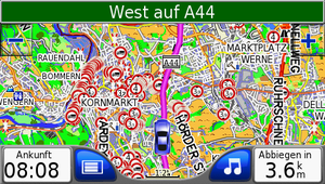
OSM Транспартная карта для прылад Garmin. | |
Note: Не цалкам перакладзеная на беларускую мову.
Абнаўленне і Спампаваць
The OSM Транспартная карта мае 12 карт. OSM Транспартная карта для грузавых і легкавых аўтамабіляў. Колькасць абмежавана да 4 м.
Newsletter for a new map, send a E-mail to: osm-transport-karte@web.de
| No. | Area | Datenstand | Data Map to: | Publication | Download | Zip | Size | New | House No. |
|---|---|---|---|---|---|---|---|---|---|
| 1 | Германія | last Update. | 09:30 Uhr | 13:00 Uhr | karte-01.zip | 1,927 GB | 1,924 GB | 1,927 GB | Yes |
| 2 | Іспанія Партугалія з выспамі | last update. | 09:30 Uhr | 13:00 Uhr | karte-02.zip | 704,7 MB | 700,9 MB | 704,7 MB | Yes |
| 3 | Нідэрланды, Бельгія, Люксембург | last update. | 10:30 Uhr | 15:00 Uhr | karte-03.zip | 822,5 MB | 818,5 MB | 822,5 MB | Yes |
| 4 | Данія, Швецыя, Фінляндыя, Нарвегія, Літва, Латвія, Эстонія | last update. | 13:30 Uhr | 15:00 Uhr | karte-04.zip | 1,880 GB | 1,680 GB | 1,880 GB | Yes |
| 5 | Францыя ў Еўропе | last update | 09:00 Uhr | 12:00 Uhr | karte-05.zip | 1,866 GB | 1,748 GB | 1,866 GB | Yes |
| 6 | Польшча, Чэхія, Славакія, Украіна | last update | 10:00 Uhr | 16:00 Uhr | karte-06.zip | 1,864 GB | 1,854 GB | 1,864 GB | Yes |
| 7 | Італія, Швейцарыя, Аўстрыя | last update | 10:00 Uhr | 16:00 Uhr | karte-07.zip | 1,503 GB | 1,397 MB | 1,503 GB | ? |
| 8 | Эстонія, Латвія, Літва, Малдова, Польшча, Украіна, Беларусь | last update | 10:00 Uhr | 16:00 Uhr | karte-08.zip | 1,374 GB | 0,0 MB | 1,374 GB | Yes |
| 9 | 1 Nord-Mittel-Africa:DZA-EGY-ETH-BEN-BFA-ERI-GMB-GIN-GNB-CMR-LYB-MLI-MRT-MAR-NER-NGA-SEN-SDN-SSD-TCD-TUN-CAF
2 Mittel-Süd-Africa:AGO-GNQ-BWA-COG-COD-GAB-KEN-LSO-MWI-MOZ-NAM-ZMB-ZWE-SOM-SWZ-ZAF-TZA-UGA |
last update 09-1 | 10:00 Uhr | 18:00 Uhr | karte-09-1.zip | 1,570 GB | 1,215 MB | 1,570 GB | Yes |
| 10 | Манголія | last update | 10:00 Uhr | 12:00 Uhr | karte-10.zip | 28,4 MB | 18,6 MB | 28,4 MB | ? |
| 11 | Румынія, Венгрыя, Чарнагорыя, Харватыя | last update | 11:30 Uhr | 15:00 Uhr | karte-11.zip | 512,9 MB | 460,5 MB | 512,9 MB | ? |
| 12 | South-America: Argentina, Chile, Uruguay, Paraguay, Bolivia, Brazil | last update | 10:30 Uhr | 14:15 Uhr | karte-12.zip | 1,642 GB | 0 GB | 1,642 GB | Yes |
| 13 | USA: Karte: 1 Arizona, Californien, Colorado, Idaho, Kansas, Missouri, Montana, Nebraska, Nevada, New Mexico, North-Dakota, Oklahoma, Oregon, South-Dakota, Texas, Utah, Washington, Wyoming | last update | 09:00 Uhr | 11:30 Uhr | karte-13.zip | 1,631 GB | 1,468 GB | 1,631 GB | ? |
| 14 | Australia, New Zealand, Indonesia, Papua-Neuguinea, Osttimor, Salomonen, Brunai, Malaysia | last update | 10:30 Uhr | 16:00 Uhr | karte-14.zip | 1,799 GB | 1,101 MB | 1,799 GB | ? |
| The following cards are now larger than 2GB. These are suitable for newer Garmin devices. | |||||||||
| 16 | United Kingdom, Ireland, Isle of Man, Island, Foroyar, Belgien, Nederland, Danmark, Norway, Swerige, Finnland | new map 2021-04-10 | 10:00 Uhr | 14:30 Uhr | wait | 3,5 GB | 3,5 GB | 3,5 GB | ? |
| 17 | Germany, Austria, Suisse, Liechtenstein | new map 2021-09-01 | 09.30 Uhr | 12.30 Uhr | wait | 2,666 GB | 2,349 GB | 2,666 GB | Yes |
| 18 | France, Espana, Portugal |
new map 2019-01-07 |
06:30 Uhr | 19.00 Uhr | wait | 2,157 GB | 2,018 GB | 2,157 GB | Yes |
Upon request additional maps can be provided. The only limit is 1.99 GB as a maximum size for .img-mapfiles.
The map automatic download
Um die neusten Karten automatisch herunterzuladen sind nur einige Schritte nötig. Der Torrent-Client muss "ADD" unterstützen z.B. Deluge. Der PC muss natürlich in Betrieb sein, z.B. Deluge muss gestartet sein und über eine Internetverbindung verfügen.
- 1. Erstellen von Verzeichnissen "osm-karte-01" von 01-12 in /Dokumente/karte
- 2. Im Torrentprogramm die Funktion "add" aktivieren, und bei der Verzeichnisüberwachung alle 12 Verzeichnisse angeben.
- 3. Das Script herunterladen torrent-download und ausführen, dies geht manuell oder automatisch (z.B. mit Geplante Aufgaben). Z.B. kann es eingestellt werden auf, "täglich zur vollen Stunde" .
Die aktuellen Torrents ab 2014-10-17 werden heruntergeladen und im Torrentprogramm automatisch geöffnet und heruntergeladen.
навіны / Pics
прывітанне
Сёння мы хочам прадставіць новую карту № 2, Іспанію, Партугалію, з выспамі.
Example Pics / Card No.1
Card No 1 Example Pics Deutschland / Sonnenstein / Jützenbacher Straße
Example Pics / Card No.3
Card No 3 Example Pics Belgien / Evergem / Wittemoer
Example Pics / Card No.4
Card No 4 Example Pics Schweden / Stockholm / Klara Söda
Example Pics / Card No.5
Card No 5 Example Pics Frankreich / Rugles / Le Mulin a Papier
Card No 5 Example Pics Spanien / Barcelona / Albareda
Card No 5 Example Pics Portugal / Guarda / Acesso
Example Pics / Card No 7
Card No 7 Example Pics Kroatien / Split / Put Supavla
Example Pics / Card No.8
Card No 6 Example Pics Polen / Szczecin / Ksiedza Alfonsa
Card No 8 Example Pics Estland / Kanepi-Varbuse Kanepi Leevaku
Card No 8 Example Pics Belarus / Braslavski Rajon / Krasnojarsky Ulica
Example Pics / Card No.9
Card No 9 Example Pics Kamerun / Douala / Avenue Douala Manga
Card No 9 Example Pics Südafrika / Musina / Hans van der Merwe Street
Card No 9 Example Pics Egypten / Sibirbai / Sibirbai
Card No 9 Example Pics Egypten / Tanta / Al-Muharidt
Card No 9 Example Pics Khartoum Sudan
Example Pics / Card No 11
Card No 11 Example Pics India Thovalai Nagercoil Bypass
Example Pics / Card No 12
Card No 12 Example Pics Miraflores Lima Peru
Zeichenliste
Die Liste, der Zeichen die in der OSM Transport Karte verwendet werden, finden Sie auf der Unterseite.
OSM Транспартная карта
features and generation
Coming next are limitations for hazardous good transports according to ADR/GGVSEB
- 1. Limitations for vehicles carrying pollutants.
First test: water hazardous goods
Changes to the map will be shown/proceed as follows.
Extras:
- My map is optimized for trucks with a height of 4 metre (13.12 ft).
- You can recognize industrial parks easier.
- The map is being optimized for trucks more and more.
- The map download is provided via torrent so that the download can be paused and continued another time.
- The sign "no truck transit" No Trucks has been improved.
- Added sign Crossbuck
- Added sign height limit. Ways with height limit are excluded in routing.
- Added weight limit (e.g. small bridges). Ways with weight limit are excluded in routing.
- Boundarys, towns, streets and house numbers are of the same date as the map itself.
- Company names are display at Garmin satnavs.
- Electricans with name are displayed after typing the address ("show on map").
- DIY stores with name are displayed after typing the address ("show on map").
- House numbers are displayed at high zoom levels.
- Steel construction and trade with name are displayed after typing the address ("show on map").
- Anzeige des Icon für Landmaschienen / Herstellung / Reparatur / Teilelager Firmen
Installation
- Bei älteren Garmin Geräten muss die interne Karte in z.B. "gmapsupp1.img" umbenannt werden, um die Karte von der SD Karte zu nutzen.
- Da nur ein Adressindex verarbeitet werden kann.
- You need a SD oder microSD card with a size of at least 4 GB.
- Format the SD card and create a directory "Garmin" in the top directory on the SD card.
- Copy the "gmapsupp.img" file you have downloaded to the directory "Garmin" (see point 2).
- Put the SD card into your Garmin satnav and turn it on.
- The satnavs recognizes the map and the map can be used. Finish.
Do not overwrite the internal file "gmapsupp.img" on your Garmin satnav in any case!
Use in a shipping company
It may be useful to let many microSD/SD cards circulate in your company. If a driver enters the premises, he can just swap the SD card.
Screenshots
Screenshots to some feautres of the map.
Maxheight:
How "maxheight" should work if tagged correctly.
"maxheight" in Sweden
- Preview for Sweden Truck map for Sweden
Successful tests
Of course, there have been made several tests, e.g. if the satnav attends maxheight limits. In truck mode maxheights below bridges below 4 metres are being considered, in car mode maxheight limits are not being considered.
If you zoom in, the name of a do-it-yourself store ist being shown, in the same manner if there is a metal construction company.
Already tested is tagging for cross traffic
As example the tags for "maxweight=7.5 t on cross-traffic", to protect a small bridge (Ziehte) from overload by to trucks that simultanious cross that bridge.
- View in Editor JOSM
- View blocked route for trucks
- View blocked road for cars.
- View free return route for trucks.
Garmin Devices
The Garmin satnavs have to support the truck mode to be able to use the full power of OSM Tranport Karte. Garmin Nüvi 660T and 560T do so.
The map also works, maybe with limitations (no truck mode, i.e. no consideration of maxheight limits) on
- Garmin Nüvi 660 T
- Garmin Nüvi 465
- Garmin Nüvi 765 TFM
- Garmin eTrex vista HCx
Nicht zu empfehlende Geräte
- Garmin Dezl 560
Loading points
A list of loading points can be found here Sub-page.
OSM Transport Karte is environment friendly!
- Our sever runs with green electricity
- You can save fuel and money because you find loading and unloading points quicklier!
- less costs because of rare damages at low bridges
- better usage of time because you know better how long you need for a trip
Country List in Garmin
Parken in Gewerbegebieten
Das Parkplatzproblem für LKW ist bekannt, jeder kennt Straßen (in Gewerbegebieten) wo man mit dem LKW parken kann. Viele dieser Möglichkeiten bleiben ungenutzt. Hier ist eine Möglichkeit der Eintragung:
Please help us improving the map!
Data improve
If you know something that is important for trucks, you can help us improving our data.
height limits, weight limits, prohibitions of transit, see also the according wiki page with more instructions.
Tagging for trucks/transport
A correct tagging is essential as base for the navigation! Editor JOSM is a very handy tool for that.
Instructions "maxheight"
a good how-to for tagging of Bridge height with JOSM.
Instructions Diy
a good how-to for JOSM.
Instructions Steel construction
a good how-to for JOSM.
Instruction agricultural business
a good how-to for JOSM.
Instructions 3D Building
a good how-to for JOSM.
Abbiegebeschränkungen eintragen
a good how-to for JOSM.
Taging for HazMat-Transportation!
How-to for water protection areas
This links to a good manual for the editor JOSM
Contact
osm-transport-karte@web.de

