|
Vous pensez acquérir un récepteur GPS pour ajouter des données dans OSM ? Ces pages sont là pour vous aider. Si vous pensez aussi à d'autres matériels, consultez le Guide matériel.
Si vous achetez un GPS par le biais d’un de nos partenaires, alors jusqu’à 10% du prix d’achat sera donné à OpenStreetMap. Cela nous aide à maintenir nos serveurs opérationnels. Voir Boutique pour les détails.
Le terme correct est GNSS (Global Navigation Satellite System ou système de géolocalisation par satellite), même si le système GPS est devenu le terme le plus utilisé (si vous allez chez votre fournisseur et demandez un GNSS, le vendeur ne saura probablement pas de quoi vous parlez, ou pourra croire que vous parlez du système russe GLONASS, indépendant du système américain GPS proprement dit, afin de savoir si le modèle est compatible avec les deux constellations, ou même avec la prochaine constellation européenne Galiléo, ou la future chinoise).
Résumé
Le fichier au format ODS en ligne : GPS List
De Acer à ATP
Brand
|
Name
|
Type
|
release date
|
GPS Chipset
|
No Channel
|
Augmentation
|
Data Logging Capacity
|
Storage
|
Connectivity
|
Estimated Price
|
Supports DOP
|
GNSS
|
measured DRMS accuracy
|
Dual-frequency
|
| Acer
|
n35
|
PDA
|
SiRFstarII
|
12
|
?
|
Illimité
|
Internal 64 MiB,  , , 
|
 
|
Discont'd
|
|
| Adapt
|
AD-850
|
Data Logger
|
SkyTraq Venus 5
|
44
|
Aucune
|
120,000 points/16-20 heures
|
|
 (charged over Mini-USB) (charged over Mini-USB)
|
€80
|
|
| AMOD
|
AGL3080
|
Data logger
|
SiRFstarIII
|
20
|
WAAS, EGNOS
|
260,000 points/72 heures minimum
|
Interne 128 MiB
|
|
GB£57
|
|
| Airis
|
T620
|
PDA
|
SiRFstarIII
|
12
|
?
|
Illimité
|
Interne 64 MiB, ,
|

|
€250
|
|
| Apple
|
iPhone 3G/s
|
Téléphone mobile
|
Broadcom BCM4750
|
=24
|
?
|
Illimité (App dependent)
|
Interne 4/8/16/32 GiB,
|
|
€100-400
|
VDOP + HDOP
|
| Asus
|
Mypal A636
|
PDA
|
SiRFstarIII
|
20
|
WAAS, EGNOS
|
Illimité
|
Interne 128 MiB, ,
|

|
Discont'd
|
|
| Asus
|
Mypal A636n
|
PDA
|
SiRFstarIII
|
20
|
WAAS, EGNOS
|
Illimité
|
Interne 64 MiB, ,
|
|
Discont'd
|
|
| Asus
|
Mypal A696
|
PDA
|
SiRFstarIII
|
?
|
?
|
Illimité
|
Interne 256 MiB, ,
|
|
€240 (May 2009)
|
|
| ATP
|
Photofinder
|
Datalogger and GPS data to Exif
|
SiRFstarIII
|
20
|
?
|
?
|
Interne 128 MiB
|
USB OTG,
|
Ca. €100
|
|
De Blumax à Evolve
Brand
|
Name
|
Type
|
release date
|
GPS Chipset
|
No Channel
|
Augmentation
|
Data Logging Capacity
|
Storage
|
Connectivity
|
Estimated Price
|
Supports DOP
|
GNSS
|
measured DRMS accuracy
|
Dual-frequency
|
| Blumax (also other brands)
|
GPS-009
|
Récepteur GPS
|
SiRFstarIII
|
20?
|
SBAS (if enabled with the free SIRF demo PC program)
|
Aucune
|
Aucun
|
|
€40+ (one of the cheapest)
|
|
| Blumax
|
GPS-4012
|
Récepteur GPS
|
SiRFstarIII
|
51
|
WAAS, EGNOS, MSAS
|
Aucune
|
Aucun
|
|
€41
|
|
| Blumax
|
GPS-4013
|
Récepteur GPS
|
SiRFstarIII
|
66
|
WAAS, EGNOS, MSAS
|
Aucune
|
Aucun
|
|
€60
|
|
| Cellink
|
BTG-7000
|
Récepteur GPS
|
Sony
|
16
|
WAAS, EGNOS
|
0
|
Aucun
|
|
US$50
|
|
| Columbus
|
V-900Columbus V-900
|
Data Logger, Récepteur GPS
|
MTK ARM
|
51
|
WAAS, EGNOS, MSAS
|
25,000,000
|
 max. 2 GiB max. 2 GiB
|
|
€109
|
VDOP, HDOP, PDOP
|
| Emtac
|
BTGPS II Trine
|
Data Logger
|
SiRFstarIIe/LP
|
16
|
?
|
24k
|
Interne 512 kiB
|
|
AU$450
|
|
| Evolve
|
routeTraxx
|
Data Logger
|
SkyTraq Venus 5
|
44
|
?
|
100,000 points
|
Interne 1 MiB
|
|
€~43
|
|
De FAC à Fujitsu-Siemens
Brand
|
Name
|
Type
|
release date
|
GPS Chipset
|
No Channel
|
Augmentation
|
Data Logging Capacity
|
Storage
|
Connectivity
|
Estimated Price
|
Supports DOP
|
GNSS
|
measured DRMS accuracy
|
Dual-frequency
|
| FAC
|
GDL30 MMC
|
Data Logger
|
?
|
?
|
?
|
Illimité
|
|
?
|
|
|
| Falk
|
F series
|
Navigator
|
ST-NXP GNS7560
|
?
|
?
|
See details
|
Interne 64 MiB - 2 GiB,
|
|
|
|
| Falk
|
M series
|
Navigator
|
ST-NXP GNS7560
|
?
|
?
|
See details
|
Interne 64 MiB - 2 GiB,
|
|
|
|
| Falk
|
N series
|
Navigator
|
SiRFstarIII
|
12
|
?
|
100,000 points per route
|
Interne 64 MiB - 2 GiB,
|
|
|
|
| OpenMoko (FIC)
|
Neo 1973 (GTA01)
|
Téléphone Mobile Linux
|
Hammerhead PMB 2520
|
?
|
?
|
Illimité
|
64 MiB Interne,
|
|
Sold out
|
|
| OpenMoko (FIC)
|
Neo Freerunner (GTA02)
|
Téléphone Mobile Linux
|
ANTARIS 4 ATR0635
|
16
|
DGPS, WAAS, EGNOS, MSAS
|
Illimité
|
256 MiB Interne,
|
|
€~229-350
|
|
| Freedom
|
Keychaingps 2000
|
Récepteur GPS
|
MTK
|
51
|
WAAS, EGNOS, MSAS
|
Aucune
|
Aucun
|
(charged over Mini-USB)
|
€60
|
Yes
|
| Fujitsu-Siemens
|
Pocket-Loox N560
|
PDA
|
SiRFstarIII
|
12
|
WAAS, EGNOS
|
Illimité
|
Interne 64 MiB, ,
|
|
€380-450
|
|
De G-MINI à GlobalSat
Brand
|
Name
|
Type
|
release date
|
GPS Chipset
|
No Channel
|
Augmentation
|
Data Logging Capacity
|
Storage
|
Connectivity
|
Estimated Price
|
Supports DOP
|
GNSS
|
measured DRMS accuracy
|
Dual-frequency
|
| G-MINI
|
GT750FL
|
Datalogger, Récepteur GPS
|
SkyTraQ Venus 6
|
65 max.
|
WAAS, EGNOS
|
256,000 trackpoints, no waypoints
|
Interne
|
|
€46
|
|
| Garmin
|
Geko 101
|
Data Logger
|
?
|
12
|
No
|
3k
|
Interne
|
No
|
|
|
| Garmin
|
Geko 201
|
Récepteur GPS
|
?
|
12
|
WAAS, EGNOS
|
10k
|
Interne
|

|
€88 (2008-08-01)
|
|
| Garmin
|
Geko 301
|
Récepteur GPS
|
?
|
12
|
WAAS, EGNOS
|
10k
|
Interne
|
|
246 US$ (16.8.2009)
|
|
| Garmin
|
Forerunner 201
|
Personal Trainer
|
?
|
12
|
?
|
?
|
Interne
|
|
€139 (2008-08-01)
|
|
| Garmin
|
Forerunner 205/305
|
Personal Trainer Linked with Google Earth
|
SiRFstarIII
|
12
|
?
|
13k OR 3,5 heures avec une mesure par seconde
|
Interne
|
|
€165 (2009-08-23)
|
|
| Garmin
|
Edge 205
|
Personal Trainer
|
SiRFstarIII
|
20
|
?
|
12k
|
Interne
|
|
?
|
|
| Garmin
|
Edge 305
|
Personal Trainer
|
SiRFstarIII
|
20
|
?
|
12k
|
Interne
|
|
€185 (2008-08-01)
|
|
| Garmin
|
Edge 605
|
Personal Trainer/Navigator
|
SiRFstarIII
|
20
|
?
|
Illimité/15 heures
|
Interne,
|
|
€225 (2009-10-01)
|
|
| Garmin
|
Edge 705
|
Personal Trainer/Navigator
|
SiRFstarIII
|
20
|
?
|
Illimité/15 heures
|
Interne,
|
|
€300 (2009-10-01)
|
|
| Garmin
|
eMap
|
Data Logger, Navigator (detailed maps extra)
|
?
|
12
|
none
|
?
|
Interne
|
|
US$100-190 (2008-12-12)
|
|
| Garmin
|
eTrex
|
Data Logger
|
?
|
12
|
WAAS, EGNOS
|
10k
|
Internal
|
|
Discont'd
|
|
| Garmin
|
eTrex H
|
Data Logger
|
MediaTek MT3318
|
51
|
WAAS, EGNOS
|
10k
|
Interne
|
|
€79 (2008-08-01)
|
|
| Garmin
|
eTrex Summit
|
Data Logger, Navigator
|
?
|
12
|
WAAS, EGNOS
|
10k
|
Interne
|
|
Discont'd
|
|
| Garmin
|
eTrex Legend
|
Data Logger, Navigator
|
?
|
12
|
WAAS, EGNOS
|
10k
|
Interne
|
|
Discont'd
|
|
| Garmin
|
eTrex Legend C
|
Data Logger, Navigator
|
?
|
12
|
WAAS, EGNOS
|
10k
|
Interne
|
|
Discont'd
|
|
| Garmin
|
eTrex Legend CX
|
Data Logger, Navigator
|
?
|
12
|
WAAS, EGNOS
|
10k
|
Interne,
|
|
GB£180
|
|
| Garmin
|
eTrex Legend HCx
|
Data Logger, Navigator
|
MediaTek MT3318
|
51
|
WAAS, EGNOS
|
10k or to SD-card
|
|
|
€167 (2008-08-01)
|
|
| Garmin
|
eTrex Venture Cx
|
Data Logger, Navigator
|
?
|
12
|
WAAS, EGNOS
|
10k
|
|
|
Discont'd
|
|
| Garmin
|
eTrex Venture HC
|
Data Logger, Navigator
|
?
|
12
|
WAAS, EGNOS
|
10k
|
Interne 24 MiB
|
|
€145 (2008-08-01) $117 (2009 Nov 9)
|
|
| Garmin
|
eTrex Vista
|
Data Logger, Navigator
|
?
|
12
|
WAAS, EGNOS
|
10k
|
Interne
|
|
Discont'd
|
|
| Garmin
|
eTrex Vista Cx
|
Data Logger, Navigator
|
?
|
?
|
WAAS, EGNOS
|
10k, ou carte SD
|
|
|
Discont'd
|
|
| Garmin
|
eTrex Vista HCx
|
Data Logger, Navigator
|
MediaTek MT3318
|
51
|
WAAS, EGNOS
|
10k ou carte SD
|
|
|
€203 (2008-08-01)
|
No
|
| Garmin
|
GPSmap 60CSx
|
Outdoor mapping GPS
|
SiRFstarIII
|
12
|
WAAS, EGNOS
|
Interne ou carte SD jusqu'à 4 GiB (since FW 3.90)
|
|
|
US$294.15 (Amazon)
|
|
| Garmin
|
Oregon 300
|
Outdoor mapping GPS
|
STM STA2062 "Cartesio"
|
32
|
WAAS, EGNOS
|
850 MiB internes ou carte micro SD (4 GiB fonctionne bien)
|
|
|
€300 (Amazon)
|
|
| Garmin
|
Nüvi 205
|
Navigator
|
SiRFstarII ?
|
?
|
?
|
940 MiB de stockage interne et carte micro SD
|
|
|
€~100
|
|
| Garmin
|
Nüvi 760
|
Navigator
|
SiRFstarII
|
?
|
?
|
Interne 10,000 points
|
jusqu'à 4 GiB
|
|
€~300
|
|
| Geneq
|
SX Blue II
|
Récepteur GPS
|
?
|
10 + 2
|
WAAS EGNOS MSAS GAGAN
|
0
|
0
|
|
~1500€
|
HDOP VDOP PDOP
|
| GiSTEQ
|
CD110BT
|
Data Logger
|
MTK
|
51
|
?
|
interne 150,000 points
|
interne 4 MiB
|
|
GB£~60
|
|
| GlobalSat
|
DG-100
|
Data Logger
|
SiRF Star III
|
20
|
WAAS
|
60k
|
Interne
|
|
US$110
|
|
| GlobalSat
|
BT-308
|
Récepteur GPS
|
SiRF Star II e/LP
|
12
|
WAAS
|
0
|
Aucun
|
|
|
|
| GlobalSat
|
BT-335
|
Data Logger/Récepteur GPS
|
SiRF Star III
|
20
|
WAAS
|
60k
|
Interne
|
|
€80
|
|
| GlobalSat
|
BT-338
|
Récepteur GPS
|
SiRF Star III
|
20
|
WAAS, EGNOS
|
0
|
Aucun
|
|
|
|
| GlobalSat
|
BT-359
|
Récepteur GPS
|
SiRF Star III
|
20
|
WAAS, EGNOS
|
0
|
Aucun
|
|
US$80
|
|
| GlobalSat
|
BT-368
|
Récepteur GPS
|
SiRF Star III
|
20
|
WAAS, EGNOS, MSAS
|
0
|
Aucun
|
|
GB£47
|
|
| GlobalSat
|
BR-355
|
Récepteur GPS
|
SiRF Star III e/LP
|
20
|
WAAS, EGNOS
|
0
|
Aucun
|
|
US$60
|
|
| GlobalSat
|
BU-353
|
Récepteur GPS
|
SiRF Star III e/LP
|
20
|
WAAS, EGNOS
|
0
|
Aucun
|
|
GB£28-57
|
|
| GlobalSat
|
BR-304/5
|
Récepteur GPS
|
SiRF Star II e/LP
|
12
|
No
|
0
|
Aucun
|
|
US$50
|
|
| GlobalSat
|
BU-303
|
Récepteur GPS
|
SiRF Star II e/LP
|
12
|
Non
|
0
|
Aucun
|
|
€50
|
|
De HP à HTC
Brand
|
Name
|
Type
|
release date
|
GPS Chipset
|
No Channel
|
Augmentation
|
Data Logging Capacity
|
Storage
|
Connectivity
|
Estimated Price
|
Supports DOP
|
GNSS
|
measured DRMS accuracy
|
Dual-frequency
|
| Hewlett Packard
|
iPaq hw6915
|
PDA
|
Globallocate AGPS
|
?
|
?
|
Illimité
|
Interne,  (max 2GB) (max 2GB)
|
GPRS
|
€500
|
|
| Holox
|
BT-321
|
Récepteur GPS
|
RFMD
|
?
|
?
|
Non
|
Aucun
|
|
|
|
| Holox
|
BT-541
|
Récepteur GPS
|
Skytraq Venus 521
|
54
|
AGPS (Widows & Symbian support)
|
Non
|
Aucun
|
|
|
|
| Holux
|
GM-210
|
Récepteur GPS
|
SiRFstarII
|
12
|
?
|
Non
|
Aucun
|

|
|
|
| Holux
|
GR-213
|
Récepteur GPS
|
SiRFstarIII
|
?
|
?
|
Non
|
Aucun
|
|
€~70
|
|
| Holux
|
GPSlim236
|
Récepteur GPS
|
SiRFstarIII
|
20
|
WAAS, EGNOS
|
Non
|
Aucun
|
(special USB cable)
|
€~50
|
|
| Holux
|
GPSlim240
|
Récepteur GPS
|
SiRFstarIII
|
20
|
WAAS, EGNOS
|
Non
|
Aucun
|
(special USB cable)
|
€~90
|
|
| Holux
|
GPSport 245
|
Récepteur GPS
|
MTK3318
|
20
|
?
|
200,000
|
Interne 4 MiB
|
|
€~100
|
|
| Holux
|
M-241
|
Data Logger, GPS Receiver
|
MTK
|
32
|
DGPS (EGNOS, WAAS, MSAS)
|
130,000 / 36hrs @ 1s
|
Internal
|
|
€~90 (09-03-2009, Germany)
|
|
| Holux
|
M-1000
|
GPS Receiver
|
MTK MT3318
|
32
|
WAAS, EGNOS
|
No
|
None
|
(special USB cable)
|
230zl
|
|
| Holux
|
M-1200
|
GPS Receiver
|
MTK MT3318
|
32
|
DGPS (RTCM, EGNOS, WAAS, MSAS)
|
No
|
None
|
(special USB cable)
|
£~25 (eBay)
|
|
| Holux
|
RCV-3000
|
Récepteur GPS et enregistreur de positions GPS suivant paramétrage (temps, vitesse, distance)
|
MTK MT3329
|
66
|
DGPS (EGNOS pour Europe, WAAS pour USA)
|
200,000
|
Interne de 4 Mo
|
(cable USB standard avec connecteur USB de type mini-B)
|
~57 Euros (08/2016, amazon.fr)
|
?
|
non
|
non
|
| HTC
|
Artemis (= O2 XDA Orbit)
|
PDA
|
SiRFstarIII
|
12?
|
|
|
Internal,
|
|
€~450 Discontinued
|
|
| HTC
|
Dream/G1
|
Mobile Phone
|
Qualcomm gpsOne
|
12?
|
AGPS (as of Android 1.5)
|
Illimité (App dependent)
|
Internal 64 MiB,
|
|
$400
|
|
| HTC
|
Magic/G2
|
Mobile Phone
|
Qualcomm gpsOne
|
12?
|
AGPS (as of Android 1.5)
|
Illimité (App dependent)
|
Internal 192 MiB,
|
|
|
|
| HTC
|
Hero
|
Mobile Phone
|
Qualcomm gpsOne
|
12?
|
AGPS (as of Android 1.5)
|
Illimité (App dependent)
|
Internal 288 MiB?,
|
|
|
|
| HTC
|
Desire
|
Mobile Phone
|
Qualcomm gpsOne Generation 7
|
?
|
GPS/AGPS
|
Illimité (App dependent)
|
Internal 512 MiB?,
|
|
|
|
| HTC
|
S740
|
Mobile Phone
|
?
|
12?
|
GPS/AGPS
|
Illimité (App dependent, GpsVP works)
|
Internal 256 MiB?,
|
|
|
|
De i.Trek à Leadtek
Brand
|
Name
|
Type
|
release date
|
GPS Chipset
|
No Channel
|
Augmentation
|
Data Logging Capacity
|
Storage
|
Connectivity
|
Estimated Price
|
Supports DOP
|
GNSS
|
measured DRMS accuracy
|
Dual-frequency
|
| i.Trek
|
M7
|
GPS Receiver
|
MTK
|
32
|
WAAS, EGNOS
|
No
|
None
|
|
€~50
|
|
| Kapsys
|
Kapten
|
Displayless Navi,
voice controlled
|
?
|
?
|
?
|
Needs firmware update to do proper logging
|
?
|
?
|
~€270
|
|
| Konet
|
BGL-32
|
Data Logger
|
MediaTek MTK
|
32
|
?
|
100k
|
Internal 16 MiB
|
|
€78
|
|
| Leadtek
|
LR 9553D
|
Data Logger, GPS Receiver
|
SiRFstarIII/LP
|
20
|
WAAS, EGNOS
|
?
|
Internal 4 MiB
|
|
|
|
De Magellan à Mobile Action
Brand
|
Name
|
Type
|
release date
|
GPS Chipset
|
No Channel
|
Augmentation
|
Data Logging Capacity
|
Storage
|
Connectivity
|
Estimated Price
|
Supports DOP
|
GNSS
|
measured DRMS accuracy
|
Dual-frequency
|
| Magellan
|
Magellan-320
|
Data Logger
|
?
|
?
|
?
|
1k
|
Internal
|
|
|
|
| Magellan
|
SporTrak Pro
|
Data Logger
|
?
|
?
|
?
|
3k
|
Internal
|
|
|
|
| Magellan
|
eXplorist 400
|
Data Logger, Navigator
|
?
|
14
|
WAAS, EGNOS
|
?
|
Internal 16 MiB,
|
|
€300
|
|
| Magellan
|
eXplorist 500
|
Data Logger, Navigator
|
?
|
14
|
WAAS, EGNOS
|
?
|
Internal 16 MiB,
|
|
€389
|
|
| Magellan
|
eXplorist 500 LE
|
Data Logger, Navigator
|
?
|
14
|
WAAS, EGNOS
|
?
|
Internal 16 MiB,
|
|
|
|
| Magellan
|
eXplorist 600
|
Data Logger, Navigator
|
?
|
14
|
WAAS, EGNOS
|
?
|
Internal 16 MiB,
|
|
€400
|
|
| Magellan
|
eXplorist 210
|
Data Logger, Navigator
|
?
|
14
|
WAAS, EGNOS
|
2k
|
Internal 22 MiB
|
|
US$275/€219
|
|
| Magellan
|
eXplorist XL
|
Data Logger, Navigator
|
?
|
14
|
WAAS, EGNOS
|
?
|
Internal 30 MiB,
|
|
|
|
| Magellan
|
eXplorist 100
|
GPS Receiver
|
?
|
14
|
WAAS, EGNOS
|
0
|
Internal 4 MiB
|
No
|
|
|
| Magellan Professional
|
MobileMapper CE
|
Professional GPS
|
?
|
14
|
WAAS, EGNOS, MSAS, Glonass, Beacon, NTRIP, Direct IP, RTCM correction
|
Illimité
|
Internal 128 MiB,
|
|
|
|
| Magellan Professional
|
MobileMapper Pro
|
Professional GPS
|
?
|
14
|
WAAS, EGNOS, MSAS
|
Illimité
|
Internal 128 MiB,
|
|
|
|
| Magnex
|
DataLogger
|
GPS Receiver, Data Logger
|
SkyTraq Venus 5
|
44
|
WAAS, EGNOS
|
100,000 points
|
Internal 8 Mbit
|
(charged over Mini-USB)
|
€60
|
|
| Mitac/Mio
|
DigiWalker C510
|
Navigator
|
SiRFstarIII
|
?
|
?
|
?
|
Internal 512 MiB,
|
|
€~270
|
|
| Mitac/Mio
|
A702
|
PDA/Phone
|
SiRFstarIII
|
20
|
None
|
Illimité
|
Internal ~1 GiB,
|
|
€~400
|
|
| Mobile Action
|
i-gotU GT-120
|
Data Logger
|
SiRFstarIII
|
20
|
WAAS, EGNOS
|
65,000 points
|
Internal 16M
|
|
€~50
|
?
|
| Mobile Action
|
i-gotU GT-600
|
Data Logger
|
SiRFstarIII
|
20
|
WAAS, EGNOS
|
200,000 points
|
Internal 64M
|
|
€~70
|
?
|
| Mobile Action
|
i-gotU GT-800
|
GPS Receiver, Data Logger
|
SiRFstarIII
|
20
|
WAAS, EGNOS
|
200,000 points
|
Internal 64M
|
|
€~100
|
?
|
| Mobile Action
|
i-gotU GT-800 Pro
|
GPS Receiver, Data Logger
|
SiRFstarIII
|
20
|
WAAS, EGNOS, Compass, Altimeter
|
200,000 points
|
Internal 64M
|
|
€~120
|
?
|
De NavGear à Nokia
Brand
|
Name
|
Type
|
release date
|
GPS Chipset
|
No Channel
|
Augmentation
|
Data Logging Capacity
|
Storage
|
Connectivity
|
Estimated Price
|
Supports DOP
|
GNSS
|
measured DRMS accuracy
|
Dual-frequency
|
| NavGear
|
PX3015
|
Data Logger, GPS Receiver
|
MTK
|
32
|
WAAS, EGNOS, MSAS, RTCM
|
170k
|
Internal 16 MiB
|
|
€~80
|
|
| Navibe
|
GB-732
|
GPS Receiver
|
SiRFstarIII
|
?
|
?
|
No
|
None
|
|
US$50
|
|
| Navibe
|
GM-720
|
GPS Receiver
|
SiRFstarIII
|
20
|
WAAS, EGNOS
|
No
|
None
|
|
US$~35
|
|
| Navibe
|
GB-735
|
GPS Receiver
|
SiRFstarIII
|
?
|
?
|
No
|
None
|
|
€~50
|
|
| Navigon
|
GoPal 2.x
|
?
|
?
|
12
|
?
|
?
|
?
|
?
|
|
|
| Navigon
|
MobileNavigator 4.X/5.X
|
Data Logger, Navigator
|
?
|
?
|
?
|
?
|
?
|
|
|
|
| Navilock
|
BT-348
|
GPS Receiver
|
SiRFstarIII
|
20
|
?
|
No
|
None
|
|
€90
|
|
| Navilock
|
BT-359
|
GPS Receiver
|
SiRFstarIII
|
20
|
?
|
No
|
None
|
|
|
|
| Navilock
|
BT-413
|
GPS Receiver
|
SkyTraq Venus 5
|
44 (?)
|
?
|
No
|
None
|
|
€30
|
|
| Navilock
|
NL-302-U
|
GPS Receiver
|
SiRFstarIII
|
20
|
?
|
No
|
None
|
|
€40
|
|
| Navilock
|
BT-455PDL (not available anymore)
|
Datalogger, GPS-Receiver
|
SkyTraQ Venus 5
|
54 max.
|
?
|
100,000 trackpoints, no waypoints
|
internal
|
|
€100
|
|
| Navilock
|
NL-456DL (EasyLOGGER)
|
Data Logger
|
u-blox ANTARIS®4 SuperSense®
|
16
|
SBAS if enabled from config. program
|
94,000
|
internal 4 MiB
|
|
€100
|
|
| Navman
|
N20
|
Navigator
|
?
|
12
|
?
|
?
|
?
|

|
|
|
| Navman
|
N40i
|
Navigator
|
?
|
12
|
?
|
?
|
?
|
|
|
|
| Navman
|
N60i
|
Navigator
|
?
|
12
|
?
|
?
|
?
|
|
|
|
| Navman
|
PiN 570
|
PDA
|
?
|
?
|
?
|
Illimité
|
Internal 64 MiB,
|
|
GB£130
|
|
| Navman
|
3450 IPAQ Sleeve
|
PDA
|
?
|
12
|
?
|
?
|
Internal,  (CF II) (CF II)
|
?
|
|
|
| Navman
|
B10
|
GPS Receiver
|
SiRFstarIII
|
20
|
?
|
None
|
None
|
(charged over miniUSB)
|
€35+
|
|
| Nokia
|
N and E series
|
Mobile Phone
|
SiRFstarII
|
?
|
?
|
Illimité?
|
Internal,
|
|
|
|
| Nokia
|
LD-1W
|
GPS Receiver
|
SiRFstarII
|
?
|
No
|
0
|
None
|
|
|
|
| Nokia
|
LD-3W
|
GPS Receiver
|
SiRFstarIII
|
?
|
No
|
0
|
None
|
|
€85
|
|
| Nokia
|
LD-4W
|
GPS Receiver
|
SiRF Star III LT
|
20
|
No
|
0
|
None
|
|
€88
|
|
| Nokia
|
N810
|
PDA (Internet Tablet)
|
TI GPS5300
|
12
|
None
|
5 MiB (Maemo Mapper)
|
Internal 2 GiB,
|
|
€450/US$400
|
|
| Nokia
|
N95
|
Smartphone
|
TI GPS5300
|
12
|
None
|
?
|
Internal 8 GiB
|
|
€450/US$400
|
|
| Nokia
|
N900
|
Smartphone
|
SiRF Star III
|
?
|
?
|
Illimité
|
Internal 32 GiB
|
|
€600
|
|
| Nokia
|
5800 XpressMusic
|
Smartphone
|
TI GPS5350
|
10
|
None
|
Illimité
|
Internal,
|
|
?
|
|
| Nokia
|
6220 Classic
|
Smartphone
|
TI GPS5350
|
?
|
None
|
?
|
Internal,
|
|
?
|
|
De Pentagram à Qstarz
Brand
|
Name
|
Type
|
release date
|
GPS Chipset
|
No Channel
|
Augmentation
|
Data Logging Capacity
|
Storage
|
Connectivity
|
Estimated Price
|
Supports DOP
|
GNSS
|
measured DRMS accuracy
|
Dual-frequency
|
| Pentagram
|
PathFinder P3301
|
GPS Receiver
|
MTK
|
32
|
WAAS, EGNOS
|
0
|
None
|
|
€69-
|
|
| Pentagram
|
PathFinder P3106
|
Data Logger, GPS Receiver
|
MTK
|
51
|
WAAS, EGNOS, MSAS
|
150k
|
Internal 4 MiB
|
|
€50
|
|
| Progin
|
T-368
|
Data Logger, GPS Receiver
|
SiRFstarIII
|
20
|
WAAS, EGNOS, MSAS
|
Illimité
|
max. 2GB
|
|
€89
|
|
| Qstarz
|
BT-Q818
|
GPS Receiver
|
MTK
|
32
|
WAAS, EGNOS
|
0
|
None
|
|
US$85
|
|
| Qstarz
|
BT-Q1000
|
Datalogger, GPS Receiver
|
MTK
|
32
|
WAAS, EGNOS
|
Yes, 100.000 datapoints, can log 5 Hz
|
Internal 2 MiB,
|
GPS: , log:
|
US$100
|
|
| Qstarz
|
BT-Q1000P
|
Datalogger + GPS Receiver
|
MTK
|
51
|
WAAS, EGNOS
|
Yes, 200.000 datapoints, can log 5 Hz
|
Internal 4 MiB
|
GPS: , log: ()
|
US$100
|
|
| Qstarz
|
BT-Q1000X
|
Datalogger + GPS Receiver
|
MTK II
|
66
|
WAAS, EGNOS, MSAS
|
Yes, 200,000 datapoints, can log 5 Hz
|
Internal 4 MiB
|
GPS: , log:
|
US$100
|
|
| Qstarz
|
BT-Q1200 Solar
|
Datalogger, GPS Receiver
|
MTK
|
32
|
WAAS, EGNOS
|
Yes, 100,000 datapoints, can log 1 Hz
|
Internal 2 MiB
|
|
€130
|
|
| Qstarz
|
BT-Q1300
|
Datalogger, GPS Receiver
|
MTK
|
66, -165 dBm
|
WAAS, EGNOS, MSAS
|
Yes, 200,000 datapoints, can log 1 Hz
|
Internal 4 MiB
|
|
€119
|
|
De Ricoh à Royaltek
Brand
|
Name
|
Type
|
release date
|
GPS Chipset
|
No Channel
|
Augmentation
|
Data Logging Capacity
|
Storage
|
Connectivity
|
Estimated Price
|
Supports DOP
|
GNSS
|
measured DRMS accuracy
|
Dual-frequency
|
| Ricoh
|
500SE+SE-1/3
|
Digital camera w. GPS
|
SiRFstarIII
|
20
|
WAAS
|
Yes, 1,000,000 datapoints/day, can log 1 Hz and 1/photo
|
max. 1GB
|
|
GB£575
|
|
| Royaltek
|
BlueGPS RBT-3000
|
Data Logger
|
SiRFstarIII
|
12
|
WAAS, EGNOS
|
30k
|
Internal
|
|
US$100
|
|
| Royaltek
|
MBT 1000
|
GPS Receiver
|
MTK
|
?
|
No
|
0
|
None
|
|
|
|
| Royaltek
|
BT GPS mini RBT-1000
|
GPS Receiver
|
MTK
|
32
|
WAAS, EGNOS
|
0
|
None
|
|
|
|
| Royaltek
|
BT GPS x-mini RBT-2100
|
GPS Receiver
|
SiRFstarIII
|
20
|
WAAS, EGNOS
|
0
|
None
|
|
|
|
| Royaltek
|
BT GPS x-mini II RBT-2200/10
|
GPS Receiver
|
SiRFstarIII
|
20
|
WAAS, EGNOS
|
0
|
None
|
|
|
|
| Royaltek
|
RBT-2300
|
Data Logger
|
SiRFstarIII
|
20
|
WAAS, EGNOS
|
400-650k
|
Internal 64 MiB
|
Ext. antenna
|
US$65
|
|
| Royaltek
|
Mini Xtreme RBT-2110
|
GPS Receiver
|
SiRFstarIII
|
20
|
WAAS, EGNOS
|
0
|
None
|
|
|
|
| Royaltek
|
RGM-2000
|
GPS Receiver
|
SiRFstarIII
|
20
|
No
|
0
|
None
|
|
|
|
| Royaltek
|
Vnus RGM-3600
|
GPS Receiver
|
SiRFstarIII
|
20
|
No
|
0
|
None
|
|
|
|
| Royaltek
|
RGM-3800
|
Data Logger, GPS Receiver
|
SiRFstarIII
|
20
|
WAAS, EGNOS
|
650k
|
Internal
|
|
€~45
|
Yes
|
De Samsung à Telefunken
Brand
|
Name
|
Type
|
release date
|
GPS Chipset
|
No Channel
|
Augmentation
|
Data Logging Capacity
|
Storage
|
Connectivity
|
Estimated Price
|
Supports DOP
|
GNSS
|
measured DRMS accuracy
|
Dual-frequency
|
| Samsung
|
Galaxy Player
|
MP3-Player
|
SiRFstarIII
|
24
|
?
|
Unlimited (Android 2.3 system. App dependent)
|
Internal 4/8/16 GiB,
|
(NMEA 0183)
|
€150-250
|
?
|
| SBS Power
|
BA480
|
GPS Receiver
|
SiRFstarIII
|
20
|
none
|
none
|
none
|
(NMEA 0183)
|
Less than €50
|
Yes
|
| Scytex/Locosys
|
NaviGPS GT-11
|
Data Logger
|
SiRFstarII
|
12
|
WAAS, EGNOS
|
80k
|
Internal,
|
|
GB£65
|
Yes
|
| Scytex/Locosys
|
NaviGPS BGT-11
|
Data Logger
|
SiRFstarII
|
12
|
WAAS, EGNOS
|
80k
|
Internal,
|
|
GB£80
|
Yes
|
| Scytex/Locosys
|
NaviGPS GT-31
|
Data Logger
|
SiRFstarIII
|
12
|
WAAS, EGNOS
|
80k
|
Internal,
|
|
GB£74.99 (Q1 2008; launch)
|
|
| Scytex/Locosys
|
NaviGPS BGT-31
|
Data Logger
|
SiRFstarIII
|
12
|
WAAS, EGNOS
|
80k
|
Internal,
|
|
GB£94.99 (Q1 2008; launch)
|
|
| Sony-Ericsson
|
C702
|
Mobile Phone
|
?
|
?
|
?
|
Illimité
|
Internal 150 MiB, 
|
|
€~280
|
|
| TomTom
|
Rider
|
(Data Logger), Navigator
|
SiRFstarIII
|
20
|
?
|
Illimité
|
|
|
€430 (Discont'd?)
|
|
| TomTom
|
GO 7X0, 9X0
|
Navigator
|
?
|
?
|
logging with Event Logger
|
Illimité
|
2 GiB internal
|
|
€200-350
|
|
| Transystem (?)
|
i-Blue 717
|
GPS Receiver
|
Nemerix
|
16
|
?
|
none
|
none
|
|
€30-50 (eBay)
|
|
| Transystem
|
i-Blue 737
|
GPS Receiver
|
MTK
|
32
|
WAAS, EGNOS, MSAS
|
0
|
None
|
|
US$45
|
|
| Transystem
|
i-Blue 737A+
|
GPS Receiver
|
MTK
|
66
|
WAAS, EGNOS, MSAS
|
0
|
None
|
|
€50
|
|
| Transystem
|
i-Blue 747
|
Data Logger, GPS Receiver
|
MTK
|
32
|
WAAS, EGNOS, MSAS
|
70k
|
Internal 2 MiB, or 4 MiB on later models
|
|
US$55
|
|
| Transystem
|
i-Blue 747A+
|
Data Logger, GPS Receiver
|
MTK
|
66
|
WAAS, EGNOS, MSAS
|
70k
|
Internal 4 MiB
|
|
€65
|
|
| Transystem
|
i-Blue 757
|
Data Logger, GPS Receiver
|
MTK
|
32
|
WAAS, EGNOS, MSAS
|
50k
|
Internal 1 MiB
|
|
US$
|
|
| Transystem
|
i-Blue 821
|
Data Logger, GPS Receiver
|
MTK
|
51
|
WAAS, EGNOS, MSAS
|
150k
|
Internal 4 MiB
|
|
€70 (~€40 ebay)
|
|
| Telefunken SAfrica
|
TGPS-374/Axxion 374
|
WinCE device
|
?
|
12
|
|
3rd party SW : Illimité
|
Internal 64 MiB
|
|
R1,700-2,000
|
|
De Visiontac à Yakumo
Brand
|
Name
|
Type
|
release date
|
GPS Chipset
|
No Channel
|
Augmentation
|
Data Logging Capacity
|
Storage
|
Connectivity
|
Estimated Price
|
Supports DOP
|
GNSS
|
measured DRMS accuracy
|
Dual-frequency
|
| ViaMichelin
|
X930, X950, X970
|
Navigateur routier
|
SiRFstarIII
|
30
|
non
|
avec logiciel complémentaire compatible WindowsCE 4.2 ex : NoniGPSPlot.
|
32 MB interne, 2 GB amovible
|
|
produit arrêté (environ €50-80 en occasion)
|
|
| Visiontac
|
VGPS-900
|
GPS logger w. voice recording
|
MTK
|
51
|
?
|
~25M records/2 GiB, limited to 100 individual tracks/datapoints
|
(64 MiB-2 GiB)
|
, SD-cardreader
|
US$100
|
|
| Wintec
|
WBT-201
|
Data Logger, Navigator
|
u-blox Antaris 4
|
16
|
WAAS, EGNOS
|
131k
|
Internal
|
|
US$89 (?)/€90 (2008-08-03)
|
|
| Wintec
|
WBT-202
|
Data Logger, Navigator
|
u-blox Antaris 5
|
18 (tracking), 32 (aquisition)
|
WAAS, EGNOS
|
260k internal / 134M with 2GB microSD
|
Internal and (64 MB-2 GB)
|
|
US$99 (?)/€109 (2009-10-24)
|
|
| Wintec
|
WBT300
|
Navigator
|
u-blox Antaris 4
|
16
|
?
|
?
|
?
|
|
€69 (2008-09-19)
|
|
| Xaiox
|
Itracku
|
Data Logger, Navigator
|
Nemerix
|
16
|
?
|
250k
|
Internal
|
|
€~100
|
|
| Xaiox
|
Marathon
|
GPS Receiver
|
Nemerix
|
16
|
?
|
0
|
None
|
|
€~50
|
|
| Xroad
|
V4150
|
Data Logger, Navigator
|
SiRFstarIII
|
12
|
WAAS/ TCM (option)
|
Up to 2 GiB
|
|
(with hacking)
|
US$~160
|
|
| Yakumo
|
DeltaX-5 BT
|
PDA
|
SiRFstarIII
|
12
|
?
|
Illimité
|
Internal 512 MiB, ,
|
|
€~250
|
|
Légende pour le sommaire
Les unités sont listées alphabétiquement (les unités pour Garmin,TomTom et /Wintec_and_Woxter sont listées sur des pages dédiées). Les récepteurs GPS sur PDA peuvent être trouvés sous le chapitre appareils PDA.
Le Type peut être :
- PDA
- le GNSS est intégré à un PDA.
- Data Logger
- le GNSS inclut un système automatique de positionnement géographique avec extraction possible vers un autre appareil électronique
- Récepteur GPS
- Le récepteur GPS peut simplement fournir une position géographique pour un autre appareil ou sur un simple écran sans utilitaire de navigation. Glonass est aussi disponible comme un backup/augmentation dans quelques Récepteurs GPS, mais actuallement pas disponible comme une unité autonome portative.
- Navigator
- le GNSS inclut un écran avec des cartes et un logiciel de navigation
- Mobile Phone
- le GPS est intégré dans un téléphone mobile
- Professional GNSS
- le GNSS est conçu pour une utilisation géographique intensive ou de précision. Beaucoup des appareils combinent aussi les différentes technologies GNSS, comme la combinaison de récepteurs GPS/Glonass.
- GPS L1/L2 Receivers
- Les récepteurs GPS peuvent aussi exploiter la fréquence et l'algorithme militaire du signal GPS. Ces appareils sont généralement des appareils professionnels ou militaires. Pour acquérir le signal L2, l'appareil a besoin d'une plus grande capacité de traitement, mais il a une bien meilleure précision que les appareils n'utilisant que L1. Les appareils portatifs de ce types sont généralement beaucoup plus grandes que la plupart des récépteurs GPS portatifs.
La Mémoire peut être :
| Internal
|
Compact Flash (CF)
|
MemoryStick (MS)
|
MultiMedia (MMC)
|
Secure Digital (SD)
|
Smart Media (SM)
|
xD-Picture Card (XD)
|
None
|
| Specify the capacity
|
|
 , ,  , or , or
|
, or 
|
, , or
|

|

|
none
|
Common GPS chipsets are:
- SiRFStar I, II, IIe, IIe/LP, IIt, III
- SiRFLoc
- SiRFXTrac
- Nemerix
- RFMD
- MTK
- Sony Solution
- u-Nav + iTrax 3rd Gen
- Atmel Antaris 4l
- u-blox
- Ublox
- Xemics
- HP6515 AGPS
- Skytraq Venus 5
- Skytraq Venus 6
Methods of DGPS correction / Augmentation can be SBAS (WAAS, EGNOS,MSAS), Beacon, NTRIP, Direct IP, IALA are free services, with various coverage. Spotbeam, Inmarsat, Veripos, HP/XP are semiglobal services but requires licenses and are not likely in handheld units.
Corrections can be transmitted as propritary formats, single station corrections, or 'RTCM' format correction list. Some receivers might use RTCM as identifier for corrections, but the source than is one of the systems mentioned above.
Alternative forms of GNSS includes: Glonass, the future Galileo and COMPASS.
AGPS is an abreviation for Assisted GPS, and is usually an enhancement for GPS enabled cell phones. It allows receivers quicker startup time as well as continuing to give positions with weak or missing satelite data.
Connectivity can be achieved by :
| Bluetooth
|
WLAN
|
IrDa
|
USB
|
Serial RS232
|
ActiveSync
|
SynCE
|
PS/2
|
|
|
|
|
|
|
|
|
|
Détails
Acer n35 GPS
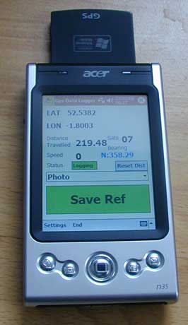 Acer n35 running GPS Data Logger The Acer is primarily a conventional relatively low spec Pocket PC PDA with built in GPS receiver and Destinator Maps (UK and Ireland maps provided in the price here in the UK). To turn it into a logging device while using the Navigation software I needed to duplicate the GPS COM port which is being achieved without problems to date using GPSGate from Franson in Sweden (US$29.95 for the Standard version, US$9.95 for the Express version). This software provides virtual COM ports for the GPS receiver so that more than one software package can access the GPS receiver at the same time.
For more on using an Acer n35 GPS see Blackadder's page. User:Steevc also has one.
The Acer n35 is almost identical to the Navman PiN 570 GPS receiver, with the software being the main difference.
Christer Weinigel was able in the spring 2005 to run Linux on the Acer n30 PDA. See also the handhelds.org wiki for the n30. The n35 is a follow-up to the n30. Where the n30 had a Bluetooth chip, the n35 has the GPS receiver chip.
The Destinator (v. 3 and up) software is able to log by itself. You get a binary format which is described by Jonas Svensson, that page also includes a plain converter. Currently you lose information about number of satellites and how good the position is, but may be an alternative if you do not wish to use extra software.
The N35 is known to have problems with the power/USB connectors with time. So after months of usage (specially in a car) the connector on the N35 will loose contact with the mother board , and the N35 battery will not be recharged nor it will be recognized in the computer.
Link
Acer N50
 an Acer N50 with a Bt-77 antenna Acer N50 is a normal PDA without an integrated GPS antenna. User EdoM use it coupled with a BT-77 Bluetooth antenna and VisualGPSce to track his movements.
Adapt (general)
Adapt now has its own page.
Alan (general)
Alan MAP 500
Alan MAP 600
AMOD AGL3080
- Good things
- Driverless - USB Mass Storage Mode
- Raw NMEA Logger
- Waypoint Button (NMEA waypoint on firmware 2.2+)
- 3× Standard AAA batteries
- Bad things
- Windows Only Firmware Flash
- No time display to take a photo of
Asus A696
This device is a PDA with
- Windows Mobile (version 6 is installed on most devices)
- GPS receiver: SiRFstarIII (Caution: static navigation is ON by default!)
- Display: 3.5 in LCD (240x320)
- CPU: Intel XScale, 416 MHz
- Internal memory: 256 MiB (the operating system reports total of 169 MiB for data storage and 53 MiB for program storage)
- SD-Card slot (supports SDHC; I use a 8 GB card. You may need to install a firmware update - download from Asus website)
- WLAN, USB, Bluetooth, infrared, headphones connector
I tested different GPS tracking software (OSMtracker, TGPS, NoniGPSPlot) as well as commercial navigation software (Navigon MN7) and everything worked well.
- Bad things
- Static navigation is activated by default. I used the SirfTech tool to deactivate it (just google for "SirfTech"). As already stated somewhere on this page, when the static navigation is activated, it is not possible to create usable tracks when moving slow, means with normal pedestrian speed (under 4-5 km/h) or slower - the GPS unit will just not update coordinates.
- Data transfer is slow over all interfaces (WLAN and USB are slow on this device, and Bluetooth/IrDA are slow per definition).
- When WLAN is activated, a blue LED is blinking; when Bluetooth is activated, an orange one is blinking. This is sometimes disturbing, especially at night or/and in the car. I found no way to deactivate these lights; tried some registry hacks from internet but they did not work.
- Good things
- Long battery time
- Delivered with all needed accessories, including USB data/charger cable for PC, AC charger, car charger cable, car mounting bracket (not very stable; the device often vibrates, which makes reading the display very difficult)
Asus GPS BT100
- Good things
- Bluetooth mobile phone should allow tracking with no cables
- Small
- Charged via mini USB connector
- External GPS antenna connector
- Bad things
- Bluetooth requires re-pairing
- No memory for standalone tracking
- Summary
ATP Photo Finder
Logging format not clear. The manual states "By connecting the ATP Photo Finder directly to your PC via USB connection, you can back up all the
logged GPS position information" but does not indicate the data format.
Logging frequency not clear. The manual says "logging interval Approx. 5 seconds" (p. 11) and "Update rate Continuous operation: 1 Hz" (p. 14).
Billionton CF-card
(by user:imi) 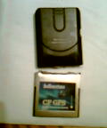 Billionton CF-card after a ski downfall. That's what I mean by "fragile". The serial CF card for PDAs and Laptops work out of the box with most Linux systems. It is the recommend card from Trisoft (The place to get the European Zaurus from).
Since it is a serial CF card, it has problems with an unpatched Zaurus C3100's serial bus driver shipped with the standard Sharp ROM. Avoid using this device with a Zaurus C3100.
- Good things
- Good supported CF card. Should work out of the box with most linux kernels.
- Cheap (compared to all-in-one solutions).
- Bad things
- Quite long CF card, so it may not fit in some PDA cases
- Very fragile (even for a CF card).
- Long cold start time (about 1 minute)
Blumax (general)
Blumax receivers can be used with any mobile phone supporting J2ME and bluetooth (using mobiletrailexplorer).
They are cheap and accurate.
While most Blumax receivers have no own storage,
GPS-4012, GPS-4043 (and most like 4044) do support data storage up to 32Mb.
Blumax 4043
This looks much i-Blue's 747 and the specs seem to be somewhat like what PathFinder P3106 offers. Price was ~60e.
Specifications according to the manufacturer:
   * Chipset: MTK chipset (but which?)
   * Sensitivity: -158 dBm
   * 51 channels
   * Power: rechargeable Li-Ion battery 1000mAh compatible with Nokia BL-5C
   * durée d"exploitation : 25+ heures (when fix'd)
   * WAAS+EGNOS+MSAS
   * Auto On-Off function in NAV Mode, always on in LOG Mode
   * Protocol: NMEA-0183 (v. 3.01)
Model info by mtkbabel:
   * FlashInfo: 1C20161C (EON,4MB)
   * Model: 0007 (iBlue 747)
   * Firmware: B-core_1.1 (TSI_747CD)
   * Logger SW: V 1.38
Cellink BTG-7000
- Price: $30–66
- Connection: Bluetooth
- Has a built-in rechargeable battery of some sort, and a car charger
- 4 or so LEDs for status
- One "hard" power switch
- Two buttons: power (stand-by?), and Bluetooth pairing
- Antenna port
- Rubberized housing
- Outputs NMEA statements at 1 Hz (by default, at least)
Works great with the Nokia N800 with "Maemo Mapper" application, and the Treo 650 with the "Cetus GPS" application. Usually sees 7–12 satellites.
DeLorme
U.S. based GPS vendor. "Earthmate" range. TODO review mapping capabilities. Can load OSM maps onto them via shapefiles. See DeLorme
EMTAC BTGPS II Trine Datalogger
- Good things
- Memory capacity and battery life allows a whole day trip to be recorded. Best on the market at the time.
- Highly flexible in what is logged: reading quality, time interval, distance interval etc.
- All in one
- Bad things
- May just be my unit, but sometimes takes a very long time to lock on; best to stay in one place and put it on a flat, preferably metal, surface until the green light starts rapidly blinking.
- Tacky by functional data download and adjustment setting software
- Proprietary download format (spec. provided)
- Introduction of SiRFstarIII chip makes this a little dated (2006)
- Summary
- Excellent for a switch-on-and-forget datalogger if you are going out for a whole day, pity it uses older SiRFstarII chipset.
FAC GDL30 MMC Data Logger
|
A simple GPS blackbox. It is designed to automatically logging an NMEA frame on a multimedia Card every time it is in use. No display, no POI on that stuff. It is used with an external active antenna and a external power supply (12 V). It is possible to redirect the NMEA signal on a COM port for using with other stuff. You can't do many things with that device, but it is really easy to use for our Open Street project.
|
 The GDL30 MMC Data Logger device |
|
Falk F/M/N Series
The Falk F/M/N Series is a Window CE based navigator. The bundled Falk Navigator software does not support vanilla data logging but with some tricks track recording is possible: [1] [2]
After unlocking the Windows desktop you can use custom programs for data logging: One of the free programs is POI Observer which is actually designed to display warnings when getting near a POI but also has data logging capabilities. The forum (in german) has the program, scripts and a walk through to unlock the Windows desktop and use POI Observer in parallel to the Falk Navigator software.
POI Observer is supposed to work with other Falk devices too.
Another nice tool is the nfRunner and the nfSpeedMenu from Navifriend-Forum. It is an excellent software for data-logging and much more.
OpenMoko Neo1973 (FIC GTA01)
The Neo1973 was the first cellular phone developed to run a OpenSource operating-system. Only a few hundredths samples have been produced for developers.
GPS-Chip: Hammerhead_PMB_2520
See also:
Fujitsu-Siemens Pocket-Loox N560
Windows Mobile 5 with freeware Odgps (program has bug in elevation). I test Noni GPSPlot now. Questions about the device can be asked to hanoj.
- Good things
- SiRFstarIII
- Up to 2 GiB of storage on a SD card
- All in one
- Bad things
OpenMoko Neo Freerunner (FIC GTA02)
A update to the Neo1973 which has the mass market as target. Not like the 1973 is has only a few hardware bugs. See GPS_Problems (now solved). While the hardware is solid, the software still has beta status.
The GPS problem is now solved. New units have a hardware fix, and a software update helps a lot for older units as well.
This is a nice gps for tracing details. You can go around a 4×4 m square, stop briefly in each corner, and get a trace with straight edges and no rounding of the corners.
The 2008.9 software includes tangogps, a nice app that shows the existing openstreetmap tiles while you trace. Navit is also an option, it uses openstreetmap for routing.
u-blox ATR0635 Datasheet
See also:
Freedom
First impressions on the Freedom Keychaingps 2000 is that it is no good in urban areas, it seems to be very sensitive to reflections from buildings. In more open areas it seems quite good and the small size is good.
Garmin
Garmin has its own page.
Globalsat BT-308
- Bluetooth
- Price approx.: GB£80
- Trackpoints: 0 points (no memory)
- Connection: Bluetooth
- SiRFstarII/LP
- Comes with magnetic external antenna and car charger (with splitter that allows the charging of iPaq at the same time)
- Channels 12
- Full review
Globalsat BT-338
- Bluetooth
- SiRFstar III (new generation ultra sensible chipset)
- Trackpoints: 0 points (no memory)
- Connection: Bluetooth
- Comes with car charger
- Full review
Globalsat BT-359
- Bluetooth
- SiRFstarIII
- Trackpoints: 0 points (no memory)
- Car charger & wall charger
- 15 hours battery time according to review: Full review, 11 hours officially. Battery from Nokia 3310/3330 fits and works, but too thick, cannot close lid. Should be slimmed versions of these somewhere.
Globalsat BT-368
- Bluetooth
- Product page
- SiRFstarIII
- Trackpoints: 0 points (no memory)
- Connection: Bluetooth
- USB charging
- une autonomie de batterie revendiquée de 10 heures
Globalsat BR-305
- USB mouse
- Price €40–60
- Trackpoints: 0 points (no memory)
- Connection: USB
- SiRFstarII
- Can't handle cold environment
- Channels 16
Works well with laptops.
Stops working on low temperature.
Uses serial USB, so it should work with all GPS track programs, loads pl2303 on Linux.
Good buy, but I recommend buying the 353 instead.
Globalsat BU-353
- USB mouse
- SiRFstarIII based
Works well with laptops.
Stops working on low temperature.
Uses serial USB, so it should work with all GPS track programs, loads pl2303 on Linux.
Good buy, this unit will almost always get a lock directly, and I really recommend it over BU-303. The sad part is that the lock usually isn't that good. I've experienced very strange behaviour where it will lose GPS lock and get a new bad lock positioning it self 50 m from the right position and then drift back to the right position. I'm not sure why this is, or exactly what is happening. It also has issues when you are stopped or moving slowly where the position jumps around by a few metres. Once it as been running for a 5–10 minutes this problem goes away.
Globalsat DG-100
 GlobalSat DG-100 Data Logger 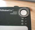 Globalsat DG-100 with washer Tip: Glueing a washer around the on/off button prevents accidental switch off when carried in a backpack
Globalsat BT-335
- Datalogger/USB mouse
- Price: €80
- Type: datalogger and GPS-receiver by bluetooth
- Trackpoints: 60,000 points
- Battery: Li-ion rechargeable, more than 24 hours from one charge
- Connection: Bluetooth
- Charge: Car and mains charger provided
- Channels: 20
- SiRFstar III chipset
- WAAS/EGNOS/MSAS enabled
- Shipped with Windows program for configuration and downloads
- Can log position; position, time, speed or position, time, speed and altitude. Recording interval could also be changed.
- Globalsat product page w/ specs
- For Mac OS, configuration and gps downloads can be made by GlobalSync. Read a review for mac [3].
- Works good with gpsd (tested with xgps on mac, start it with gpsd -p /dev/cu.BT-GPS-.... after you have paired the device the mac)
- User review
Globalsat BR-304
- RS-232
- Price 50e-70e (new), 30e-40e (used)
- SiRFstarII
- Channels 12
- No internal memory
- Connectors RS-232 and USB or PS/2
As far as I know this is BR-305 with RS-232 connection instead of the USB. Bad thing about this connector is it doesn't have pins for voltage, so there is another connector (PS/2 or USB) for power, and that connector is in the end of a really short piece of wire, because of which I had to get USB-extension. It may seem stupid to use both RS-232 and USB, but the reason is that when USB is used only for power, the receiver doesn't need any drivers at all, in any OS. Another difference between this and 305 is that this one seems to work well in cold, I got to test it in −27 °C for about half an hour.
GlobalTop GTop66 plus
The GTop66 plus is an ultra-slim Bluetooth GPS receiver. It has Bluetooth and USB connectivity. It uses the MTK ??? chipset, supporting 66 channels and AGPS. The default update rate is 300 ms, but this can be adjusted downward with suitable software. The AGPS loader software supplied crashes on my PC, so I have not been able to try AGPS yet. Thet battery is integrated into the unit, charged via the mini-USB socket. Battery life is at least several hours of continual operation. In use the unit performs very well, giving a nice stable trace at walking speed.
Holox BT 321
A Bluetooth GPS that talks NMEA. Only three lights (Bluetooth active, GPS fix/no-fix, low battery/charging), and no memory. The battery is easy to replace though, is the same as in many Nokia phones, and can be charged via USB. The GPS is nice and small (8×5×2 cm), and generally sells on eBay for around to GB£30 mark (inc. P&P).
Since it talks NMEA, it works with most software, but you do have to do most of the processing on something else. There are a number of very nice programs for Series 60 phones (e.g., GETrack to log to GPX, nmea_info.py to log and show location, satellites etc), and also any normal PC software that does NMEA works fine too.
The Holox BT 321 is a rebadged BT74R made by the Telemax Technology Corp of Taiwan, it uses the RFMD chipset, and can even get a fix indoors. Sadly the RFMD chipset is not so great when using it on foot near buildings, it can give direction information that changes with every step. Walking down the middle of the road is fine however!
It does work very well in the car or on bike however, and doesn't need to see the sky; it will work in a pocket or bag. Overall for ease of use, price, its quick time at getting a fix, its a good entry level device.
Holox BT 541
Externally very similar to the Holox BT321. A Bluetooth GPS that talks NMEA. Only three lights (Bluetooth active, GPS fix/no-fix, low battery/charging), and no memory. The battery is easy to replace though, is the same as in many Nokia phones, and can be charged via USB. The GPS is nice and small (8×5×2 cm), and generally sells on eBay for around to GB£30 mark (inc. P&P).
The Holox BT541 uses the Skytraq Venus 521 chipset which supports AGPS. Skytraq provide a free AGPS download application for Symbian and Windows. Time to lock, and typical accuracy are very good when AGPS is used (can be a bit tempramental without it). Early firmware versions had problems with track drift (firmware is upgradeable, but difficult to find the latest version).
The BT541 has a motion detector (sounds like a ball bearing in a box) that allows the device to go into a low power mode when not moving. This can give a battery life of many days depending on usage.
The BT541 seems to have very slow filtering that sometimes kicks in at walking speeds, giving lag of around 30 seconds and causing inaccurate tracking when walking around corners.
Overall for ease of use, price, its quick time at getting a fix, its OK, but frustrating for getting good pedestrian tracks.
More Info:
Holux GM-210
Holux GM-210 works with Windows Vista, Ubuntu Feisty and PalmOS. It's only an cable-based GPS-Receiver, so you need an extra device like a Palm or notebook. The GM-210 has a PS/2 port and several adaptor cables to USB/Mini-USB/Serial. No specific drivers needed, works with gpsd (Linux).
More info:
Holux GPSlim236
This is a bluetooth device, about the size of a small matchbox (46.3x67x19mm). Its lithium battery lasts about 10 hours, and is a standard model so you can get a cheap spare from eBay, etc. You can charge it via mini-USB but can't transmit data over this, as you need a special cable from Holux. I haven't tried this - Bluetooth is fine for me. The USB cable gives to possibility to upgrade the firmware (enable WAAS/EGNOS) and disable the Static Navigation (bad for pedestrian use) with SirfDemo.
Have used this with a laptop, Dell Axim PDA and Nokia 6230i with no problems. It has a SiRFstarIII chipset so is quick and accurate in getting a fix, with the usual caveats of 'canyoning' in cities. Standard NMEA output.
Had mine about 2 years. It failed after about a year but was promptly replaced. The newer GPSlim240 has a similar spec. but no replaceable battery, though it's a bit smaller.
More info:
Holux GPSlim240
Also a Bluetooth device as the GPSlim236, but this unit is more compact (64×22×15mm3), slightly less battery life (somewhere between 6-8 hours). Data is transmitted over SPP Bluetooth and gives standard NMEA output. Receiver should be up to 3 meters away. Packaging includes USB cable and car lighter adapter (Caveat: This should be obvious, but always remember to check the package contents list before buying; never had any trouble so far, but it's always good to be careful) for charging up the battery. Claims to have WAAS/EGNOS demodulator included, but never tested this. The unit has room for a lanyard which is not included in the package. Its only control is the on/off switch, and it has three LEDs for indicating low battery power, Bluetooth connection status and GPS signal acquisition.
This unit was successfully used with Bluetooth-enabled laptops and Nokia N80 with only one firmware-related problem. Care should be taken not to use SiRFdemo's "Synchronize Protocol/Baud Rate" option on Bluetooth devices, or to otherwise tinker with this unit's baud rate, as this caused it to output garbage from that point onward. Turning it off and back on didn't work. Letting it run out of battery charge didn't work. What solved it was opening up the unit, finding the battery and shorting two of the three battery terminals.
More info:
Holux GR-213
This is a simple receiver that is to be connected to any computer. Delivered with a driver for most recent Windows. To make it run under Linux, just compile your kernel with support for pl2303 serial-to-usb (as a module or into kernel), then everything should be fine with GPSd.
It features a magnet, which is quite useful to put it outside your car, on the roof. I could ride at 130 km/h in quite heavy wind without having it to move a millimeter. It is also completely waterproof (once, i've forgotten it, and after being covered by 5 centimeters snow for a few hours, it still works).
It outputs standard NMEA.
Holux M-241
- Article principal : Holux M-241
Holux M-241 can be used as datalogger or as receiver via the Bluetooth interface. It runs with a single AA alkaline battery, in logging-mode up to 12 hours.
Under Linux, Java Phones, Palm and WinCE it can be used with BT747 (you will have to set the Baud rate to 38,400 bit/s).Also for Linux, mtkbabel helps you extracting/formating GPX files and clearing memory for next uses, much as gpsbabel works, and scriptable.
More info:
Holux M-1200
The M-1200 is Bluetooth device, though can be used with a custom USB lead. It is a sealed unit with a rechargable lithium ion battery. Recharge via USB or included car lighter lead. It uses the MTK MT3318 chipset and claims up to 23 hrs per charge. Colour LEDs show satellite lock, bluetooth connection and low charge.
They can be bought on eBay for about GB£25. Performance seems much the same as my older GPSlim 236, in a slightly smaller package. Only disadvantage is not being able to carry a spare battery. More info at Holux's site --LeedsTracker 18:50, 22 January 2009 (UTC)
HP iPaq hw6915
Windows Mobile 5 device (WinPDA), with integrated GPS, camera, GSM phone, wifi and square 240x240 pixel display.
Official site,
technicalities.
- Good things
- Quick GPS connection with A-GPS made by GlobalLocate (finds satellites even trough thermally protected windshields, where other older GPS units cannot)
- Up to 2 GiB of storage on a mini SD card (for maps, track logs, etc.)
- Integrated camera and microphone could be used instead of note-taking with pencil.
- GPRS/EDGE connectivity for real-time tracking anywhere, wlan where available
- Compact, all in one (like a big GSM phone)
- Windows (relatively easy software development)
- Bad things
- Windows (has to be rebooted every few weeks to regain leaked memory)
- Battery life (around 4 hours with GPS and no WLAN or Bluetooth turned on, can be prolonged by turning off the display, probably also by turning off the GSM part...have to tested that once)
- Mini SD card can easily be lost (using sellotape to keep the second one in the slot for sure)
- Some software doesn't adopt nicely to the square screen
- No GPS mapping software that would use ALL the device's features seamlessly (GPS, camera, voice recording, connectivity) exists ... yet.
- GPS traces seem to be "smoothed" - in sharp corners track continues straight and only turns slowly later on.
HP iPaq rx5940UK
Windows Mobile 5 device (WinPDA), with integrated GPS, WIFI, Bluetooth 2.0 and USB 2.0
- Good things
- Integrated 2 GiB of storage of which around 400 MiB is free for user apps and data. The rest contains the TomTom maps of Europe.
- Integrated microphone could be used instead of note-taking with pencil.
- No COM port splitter software is needed. Hardware wise the GPS is on COM1, but the applications can all access it simultaneously on COM7 at 4800,57600 or 115200 baud.
- Bad things
- No phone, no camera
- Not sold anymore (and this only one month after I bought it)
- Compared to AD-850 loses signal more often.
HP IPAQ 3970 windows PocketPC 2002
- Getting it working
- Flash the PDA BIOS to version 2.10.
- Flash the NAVMAN 3450 firmware to the latest version - only if it's the external antenna version!'
- Install the HP IPAQ SD memory card update version 1.1 , allows modern 1 GiB plus SD cards to be recognised.
- Install SmartST serial drivers version 3.1.6 (solves the sleeve not recognised problem).
- Once you identify the com port assigned, and set the baud rate, you should start to get a data stream. In my case it was COM6 baud 56700.
- Using a simple GPS data logging program, you can collect and store track data.
- If the antenna connector will not seat, do not force it as this will bend the central pin or squash the plastic sleeve that surrounds the central pin. If it is bent, very carefully straighten it with tweezers, although you might need to replace the connector port (strip and solder job). I recommend getting an MCX male to SMA (threaded type connector), and an SMA to MCX female connector if you want to plug and unplug the antenna a lot. The SMA threaded connectors are self centering so are much better. A cheaper alternative is to make a pair of short fly leads with the MCX / SMA connectors on each end, be aware you will get signal strenght loss, how significant this will be depends on the quality of the adapters / fly leads.
- Alternatively buy an antenna with a SMA connector instead and use an adapter.
- Category:Ipaq users
HTC Artemis (=O2 XDA Orbit)
HTC Artemis is a PDA using Windows Mobile 6 Pro OS.
It contains a Lithium Ion accumulator.
More info:
HTC Hero
HTC Hero is a Mobile Phone running Android. It has a replaceable MicroSD card for tracks or geotagged images, and the posibility to expose this as a removable drive for Windows/Linux/Mac computers.
- Software
Geotagged images:
Footprints is a photo geotagging application that comes with the phone. With the GPS active, you can use it to take photos and later export them as *.kmz-files to the MicroSD. These can be unzipped for access to geotagged JPG files. These can then be viewed in for example JOSM using the AgPifoJ-plugin.
Tracks: The phone is not delivered with any application that easily can be used for gps tracking. My tracks from Google is a Android application avalible in the Marked that can save tracks and later convert these to *.kml og *.gpx for you.
i.Trek M7
GPS receiver. Very fast fix time. 5 Hz updates. Charges via USB. It can be used both via USB (USB-serial emulation working fine on Linux) and Bluetooth.
Kapsys Kapten
Homepage of manufacturer: http://www.kapsys.com
Voice controlled navigation device, suitable for the blind, no display.
Leadtek 9553/9553X/9559X
- Good things
- Small and light (around 70 g)
- Charges via USB (though the USB cable is a custom mini-A, includes car adaptor)
- The SiRFstarIII chipset gives a good accuracy
- Good internal antenna
- Bad things
- No external antenna connector (except 9559X)
- Summary
If you always carry around your PDA or notebook to get traces, this is a very good GPS receiver for a fair price.
Leadtek LR 9553D
- Good things
- Good quality build
- Very long battery life (SiRFstarIII Low Power chip)
- Both USB and Bluetooth are bidirectional port (can access to SiRF chip with SirfDemo)
- Recognized as (pseudo) Ultra Mass Storage (as an USB drive) to get log file
- Bad things
- I said pseudo Ultra Mass Storage because to set the logging interval and erase the log file it (their software) sends nasty USB commands.
- Erasing the log only works by formatting the device under Windows. The device recognizes a special USB sentence to know it's being formatted. This doesn't work under linux (mkdosfs), meanning it's impossible to erase the log file.
- LEDs are difficult to see.
- Summary
- A really great GPS, perfect for Windows users.
Magellan
- Article principal : Magellan
Magellan Professional - MobileMapper CE
Mobile Mapper CE is a rugged DGPS device which runs on Windows CE.
The GPS feature offers 14 parallel channels and can use DGPS correction from EGNOS, WAAS or GLONASS. So you can get a submetric precision. Generally it take a few minutes to initialize and fixing a new position and a few more to get on DGPS. Then, it's very fast to get a new fix even when it is partially obstructed by masks.
It's rugged and waterproof (1.5 m) and the lithium-ion battery is designed to give 8 hours of power.
You can directly share data with SD Memory Card, by connecting with ActiveSync or with Bluetooth.
The Mobile Mapper CE is particulaly designed for GIS professionals so you can find mobile GIS software which run on it like : Arcpad or Edipocket. Softwares takes benefit of the windows CE .NET environnement, the full-color display with touch panel and the integrated alphanumeric keyboard.
I have made a comparative log of a Thales MobileMapper CE (MMCE) and a FAC GDL30 MMC DATA LOGGER (a kind of GPS blackbox). You can see it here : [4] It's :
- 2006 08 03 Romans Sur Isere Grenoble Albertville Ugine Les Contamines Montjoie FAC GDL30 MMC DATA LOGGER.gpx.gz
- 2006.08.03.A.GPX.gz for the MMCE
I have never use any Garmin GPS so I don't have any point of comparaison for urban mapping. But, one of the purpose of the MMCe is its quality of detecting SNR signal (Signal sur bruit in french) and the ability of fixing it. It is specially dedicated of using in urban environnement (to avoide urban canyoning effect) and under the forest canopy.
The MMCE is more dedicated for static mapping than for kinetic mapping. It is not configured to estimate a point with the coordinates of last one evaluated with speed and azimuth.
The main difference between the MMCE and MMPro belong to the software. The MMCE comes with WindowsMobile CE (v. 5?) but without any mapping software. The MM Pro come with Thales mapping software. Alban 07:56, 15 Aug 2006 (BST). edited by Blackadder 08:34, 15 Aug 2006 (BST)
See also:
Magellan Professional - MobileMapper Pro
...
Magnex DataLogger
- Price: €~60
- Track rate: 1 Hz (configurable, but only from a (Windows) PC with dedicated application)
- Battery life: around 20 hours
- Connection: Bluetooth 1.2
- Max. satellites: 44
- Chipset: SkyTraq Venus 5
- Dedicated PC application can be used to read the log, clear it, and convert it to kml (Google Earth) format. It can also be used to read out the live position (NMEA).
- Good things
- Cheap datalogger, similar to Adapt AD-850 above
- It works with gpsd with serial-over-usb (PL2303) and with serial-over-bluetooth (rfcomm). Tested both with gpsdrive.
- Small and light (7.7×4.3×1.8 cm, 55 g)
- Quick fix and keeps working under foliage, underneath trees, inside some buildings/structures and often inside trains.
- Goes a long way on one battery charge
- High memory capacity for log points (8 Mibit, or ~100,000 points)
- Can be used as a GPS mouse (BT) (NMEA output)
- Bad things
- When connected with usb-to-serial, bluetooth doesnt work anymore
- The Windows application (iTravel-Tech gpsPhotoTagger) exports bad XML/GPX format (sometimes malformed, always without linefeeds)
- Not possible to reset logs without a PC; i.e., there is no application to do so from Windows Mobile and for Linux
- No external antenna (not needed either)
- Battery can be replaced but is proprietary: 3.7 V Li-Ion Battery Pack (mobile phone battery, ?)
- Only a charger for in the car is deliverd with it, no mains. It's a standard mini-USB connector though, so it can be charged from a computer as well or with this: Keomo Charging Bank External Accu (2200 mAh).
- Data format (.log) seems to be non standard. See comment below.
- Remarks
- The Windows software which came with the device can convert the proprietary data format (.log) to Google Earth's .kml though and export to GPX, but the last one is often malformed. Linux's gpsbabel can translate KML to GPX which in turn can be read by JOSM, for example. Note that .gpx files created from .kml files lack time stamps, hence are not suitable for upload to the OSM Server.
- The Windows software segfaults on current trunk wine version.
Motorola A780
 Motorola A780 Linux-Smartphone showing the OSM map of Ludwigsburg with BikeAtor The Motorola A780 mobile phone with build-in GPS receiver can be used with the BikeAtor-Software to track GPS. New versions of BikeAtor directly store tracklogs in GPX format compatible with JOSM.
The original battery only lasts about 2 hours, but of course it could be replaced with one of a higher capacity to easily double the time. Other devices might give more exact results, but keep in mind: It's a cellphone with full navigation on board! No need for thinking about if you will or won't need your GPS - it's there, because you won't leave your cellphone at home, will you?
Mio P550
Mio P550 is a PDA that runs Windows Mobile 5. It has a built-in GPS module with the SiRFstar III chipset. It´s possible to attach an external antenna. The device also features Bluetooth and WLAN. Car mount is included in the package. The device can be bought with or without included maps and navigation software from MIO. A few of the devices sold before August 2006 had a problem with weak signal level, but the problem has now been acknowledged by Mio. Questions about the device can be asked to user:eriso
- Good things
- GPS chip SiRFstar III
- Up to 2 GiB of storage on a SD card
- All in one
- Bad things
- Windows (crash, bluepage, etc)
- Battery life (around 4 hours with GPS and not WLAN or Bluetooth turned on).
The main problem with battery life appears to be caused by the Windows ActiveSync software continually trying to make PC contact. To fix this, follow this link: http://www.gpspassion.com/forumsen/topic.asp?TOPIC_ID=56706&whichpage=10
This details a procedure which adds a dummy connection, then sets ActiveSync to manual. As a result, battery life is extended considerably. The Mio software also seems to be a bit of a battery hog. If you just want to log your track, look at Beeline GPS software - its inexpensive and includes a lot of useful geo-caching functions for quick annotation.
Mitac/Mio DigiWalker C510
A standard car navigation unit driven by SIRFstarIII and WinCE with simple media support and Bluetooth.
As delivered the iGo software is completely useless for mapping, since it is not possible to get the GPX files out of the device. However, if you don't mind voiding the warranty, go to http://www.gpspassion.com/forumsen/topic.asp?TOPIC_ID=61233&whichpage=1 and learn how to hack it to add that feature (it is quite easy).
- Pros
- Quite accurate
- Very good for car navigation
- Easy hackable if you are into that sort of thing
- Add a cheap SD card for practically infinite mapping
- Cons
- Does NOT work for mapping without hacking
- Low battery time, made worse by the device locking with a battery warning at 25%
- Takes ages to recharge
- Occasional "blue screens"
NavGear PX3015
Really look like Transystem i-Blue 747
- Good things
- Easy to use : plug on 'Log' to start logging, 'Nav' to enable Bluetooth communication, 'Off' to stop.
- Small 46.5×72.2×20 mm
- Charge on USB
- Removable battery
- Deliver with a car lighter charger + normal charger
- Documentation include a Quick Start guide and a complete documentation
- Bad things
- No external antenna port for precise in car logging
- Quick start Guide only in English
- Software for Windows only
- Saving capcity in raw NMEA, CSV, or KML but no GPX
Navibe GB732
Interface: Bluetooth
Display: none
Memory: 0 Trackpoints
Chipset: SiRFstarIII
Price: €~50 (eBay)
The GB732 seems to be a pretty cheap and good device. It is proven to work with PC, Nokia 6230i and Nokia E61. The signal strength is pretty good and it outputs NMEA. Coupled with the Nokia 6230i running TrekBuddy it's a perfect solution for logging. The 6230i has a slot for MMC cards (up to 256 MiB) and TrekBuddy logs to the GPX format. This format can be used directly to upload it to OSM. Alternatively it can log to NMEA. It also has a separate rechargeable, replaceable battery (compatible with Nokia 6230i) with 1050 mAh, a hard power switch (no standby) and an external antenna connector (not really necessary since the internal antenna gets lock on 6-8 satellites outside). The device has 3 LEDs: Bluetooth, Battery, Satellite. It seems to be made in China since the manual and the drivers CD feature simplified and traditional chinese as main languages (others available, too). It comes with a USB recharging cable (USB -> MiniUSB), a car charger and a normal charger. All in all a good device for a small price.
- Good things
- Bad things
- Don't move it during startup, it won't get a lock
- Signal quality really sucks when carried in pocket. The device must "lay flat on the floor" for good signals.
- In narrow streets with high buildings the signal might "drift" (moving north west while in reality you only move west). Standing still for a few seconds helps the device to get you back in position.
Navibe GB735
- Interface: Bluetooth
- Display: none
- Memory: 0 Trackpoints
- Chipset: SiRFstarIII
- Price: €~50 (eBay)
It is proven to work with PC and SE K600i (with TrekkBuddy).
- Good things
- BL-5C Li-ion battery (used in few Nokia mobiles as well) removable by user
- AC charger and car charger in bundle
- Bad things
...
Navibe GM720
- Interface: USB
- Display: none
- Memory: 0 Trackpoints
- Chipset: SiRFstarIII
- Price: US$35 (eBay)
Works very well in combination with gpsd on Linux. Very cheap, but comes with minimal documentation and without software.
It is also possible (although unlikely, and this is not a specific risk for this particular device but probably for each "gpsmouse" device) to mess up the settings in such a way that one cannot connect any more with the device, leaving one no solution but to open it and disconnect the battery (which is soldered) to reset the device to its factory defaults. Of course this voids your warranty. See also the utility SirfDemo.
Navilock BT-359
 Navilock BT-359 beside a Nokia 6300 running GPS Track It's the same as the Globalsat BT-359 (except the logo).
Connection: Bluetooth
- Based on SiRFstarIII chipset (most time a good fix)
- Battery pack removeable
- 3 status LED: Power status (charging, full, low power), Bluetooth and Fix (>= 4 satellites)
- On/off button
Works good with Nokia phones (6230i and 6300) and GPS Track.
Navilock BT-348
 Navilock BT-348 with car charger Connection: Bluetooth
- Based on SiRFstarIII chipset (most time a good fix)
- Lithium-ion battery pack removeable
- 3 status LED: Power status (charging, full, low power), Bluetooth and Fix (>= 4 satellites)
- On/off button
- 72×40×23 mm
Works fine with: gpsd (Mac), Cetus GPS (Palm), cotoGPS (Palm), GPS4Palm (Palm).
Navilock BT-455PDL
Photo Data Logger
Connection: Bluetooth and USB
- Price: €99-119
- Type: datalogger and gps-receiver with Mini-USB and Bluetooth connectivity
- Chipset: SkyTraQ Venus 5
- Datalogger capacity: 100,000 trackpoints, no waypoints
- Battery: Li-Ion battery pack, removeable, ca. 8 hours
- Charge: Mini-USB, charger und car-adapter provided
- Connection: Mini-USB and Bluetooth
- Size: 70×28×20 mm
- 3 status LEDs (green: GPS fix, red: power, blue: Bluetooth)
- 1 on/off switch
- GPS receiver can be used with USB (via the Prolific USB2Serial driver) and/or Bluetooth serial port emulation, any system (but no software provided)
- DataLogger can only be used with windows
- More info: http://www.navilock.de
Mini-CD with proprietary software, installs as iTravel-Tech Application. Functions:
- Upload data from device,
- Google,
- PhotoTagger SW,
- Upload photos to Flickr,
- Configure device
- Installs Prolific USB2Serial driver
Not so good things:
- Bluetooth cannot be disabled
- No waypoints
- Requires proprietary software to read the logged gpx data
- Software for windows only
- Default installation requires administrative rights to run; but if you install into a writable directory instead, you can use it as ordinary user
- Only google supported
Navilock NL-302U
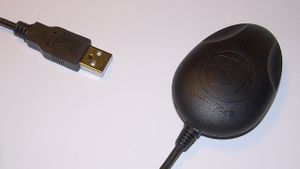 Navilock NL-302U USB GPS Receiver Based on the engine board EM-411 from Navilock mounted in a more or less waterproof casing and an attached USB cable.
Connection: USB
- Based on SiRFstarIII chipset (most time a good fix)
- USB Powered (max. 100 mA)
- 1.5 m USB cable attached to the device
- PL2303 USB-Serial converter chip (good Linux driver support)
- Single status LED near the cable outlet (might not be available on earlier devices; might not work when in binary mode)
- Very accurate when used in a car
not very accurate when hold in hand, accuracy seems to depend on direction towards sky accuracy was quite good now, I think last times this was just due to quite bad conditions... --Cobra 18:11, 10 November 2008 (UTC)
Works good with gpsd!
Navilock NL-456DL (EasyLOGGER)
(Wintec WPL 1000 Easy Showily)
Connection: USB
- Based on u-blox ANTARIS®4 SuperSense®
- Powered by battery (2×AAA(LR03, size S)) (ca. 15 hours)
- Can be powered by rechargable batteries as well (2×AAA). (1100 mAh NiMH ca. 12 hours)
- Logs 94,000 trackpoints
- Push to fix to record specific waypoints
- Small display for status
- USB-interface for reading log files and configuration via windows-software (GPX export possible)
- Linux and macs are not officially supported, device appears as storage, but the original log files seem to be in proprietary format
- Free linux/mac reader wpl1000reader (makes gpx), for change of settings windows is still needed
- Another free reader, also for change of settings [5] naviread_v0.2.1.zip naviread_v0.2.1.linux.tgz
Good experience: small, lightweight, concentrates on basic features, cheep in Germany (70.0 Eur), Possibility to set PDOP, TDOP, Sat Nr masks,... for user that knows the GPS parameters quite well
Bad experience: insufficient manual with mistakes, not enough informations for beginners in GPS, files can't be copied or downloaded from stick and need transformation by included software. --Snail044 15:24, 29 June 2008 (UTC)
Software update crashed. Could be saved by manually downloading the *.img file on the stick and cycle power :-) HB9DTX 28 August 2009
Navman/Mio Moov
S35 model approx $NZ300 including NZ navigation
- Primary purpose car navigation
- About 3 hours battery life. Charges from car or USB
- Appears as storage device to pc
- Stores tracklogs as 1 sec NMEA format "\My Documents\LOGnnnn.LOG" Convert with gpsbabel -inmea -fLOG0001.LOG -ogpx -Flog1.gpx
- Has 1 GiB internal flash (about 800 MiB free), plus SD slot
--EliotB 00:47, 11 January 2009 (UTC)
Medion (general)
Here you can find information about the hardware of almost every Medion (german only): Wiki on gopal-navigator.de
Medion GoPal Navigator 3 ME
- Type: Navigation System
- Operating System: Windows CE Core 5.0
- Interface: USB
- Display: touch screen 320×240 px
- Memory: internal flash 1 GiB (probably less than 41 MiB free), optional SD-card possible (2 GiB tested), use of larger SDHC-Card unknown
- Chipset: SiRFstarIII
- Rechargeable battery built in, battery life: min. 3 h, car adapter included, recharge via this adapter or USB
- Tracking update frequency: 1 Hz
Sold at ALDI-Nord as Medion MD 96310 (E3210), navigation system. Software supports tracking, but this function is disabled by default. If a folder named "Tracks" is created, the device logs all tracks there. This folder can be located either on internal flash disk (in folder "\My Flash Disk") or on optional SD-Card (in folder "\Storage Card"). The internal flash disk has very limited free space, the SD-Card can at least be up to 2 GiB in size. Tracks are stored in *.trk format, which can easily be converted to *.gpx with GOPALnachGPX([6]). Data transfer via USB and Active Sync (works fine with Windows 2000 and XP). As this device is a navigation system there aren't any controls for GPS, although some people created alternative skins which give more control. Tracking runs always in background if the navigation is running, in card view mode as well as in navigation mode. The recorded track contains the real positional data, not aligned to any street data.
Medion GoPal Navigator 4 ME
- Type: Navigation System
- Operating System: Windows CE Core 5.0
- Interface: USB
- Display: touch screen 320×240 px
- Memory: internal flash 1 GiB (probably less than 10 MiB free), optional SD-card up to 2 GiB
- Chipset: SiRFstarIII
- Battery life: min. 2 h, car adapter included
- Tracking update frequency: 1 Hz
Sold at ALDI-South as Medion MD 96860 (E3212), navigation system. Software supports tracking out of the box. The recorded track contains the real positional data, not aligned to any street data. To turn tracking on, do this:
- Press M button to leave the map display
- Press the button for the system setup
- Select Programm settings
- Make sure Plot GPS track is activated
The track will be saved in *.gpx format in the folder "/My Flash Disk/UserTracks". Merkaartor and josm can load the tracks out-of-the-box.
Medion PNA470T
- PNA470T: Personal Navigaton Assistant 470 Tmc
- Operating System: Windows CE Core 5.0
- Processor: Samsung ARM920T-S3C2440A
- GPS: SiRFstarIII
- Display 4.3 in, 480×272 px
Navigon MobileNavigator 4.X/5.X/6.X
The software is able to store the NMEA logs parallel to normal card view, but also in navigation mode. It is the real GPS position stored and not the displayed one!! The software tries to position the arrow always on the nearest street.
First you have to edit the file NavLib.ini in the MobileNavigator folder (MN|6: Edit mn6/NaviLib.ini). Search here for the section [GPS]. If it not exist create it. Then enter the line Autolog=1. This enables the logging function. 0 means no logging. Store the file.
All logs are stored in the Windows folder (From MN|6.2: Stored in mn6 folder). So be careful with long trips! They are named "GPS Log Day-Month-Year Hour-Minute.txt".
When your tracks are logged you can move the files with ActiveSync on your computer and translate it with gpsbabel from NMEA to GPX. And now you can load them into josm.
Navman 3450 IPAQ Sleeve
A GPS receiver built into the IPAQ expansion-pack form-factor. Although the earlier models suffered from RF-interfence and excessively long warm-up times, the 3450 model seems to have solved most of these issues.
It also has an external antenna connection for improved in-vehicle reception.
Once the unit warms up (1-3 minutes), it will find and hold lock with clear skys with ease. Performance near buildings and under trees is also quite good, as it will often hold a 3D lock.
I found the visualGPSce program to work well.
Navman support Click on the PocketPC image. Click on the 3450 image.
- Navman serial driver - you want the article titled - Serial Drivers for GPS 3100/3300/3400/3450
- Navman firmware update - you want the article titled - GPS Firmware Upgrade
- Navman GPS tool (good for diagnostics) - you want the article titled - GPS Info Tool for Pocket PC
- Good things
- Can be found cheap on ebay
- If you get the original pack, it comes with the SmartST software, a windscreen mount and incar power-supply.
- PDA screen/touch screen interface/good for making notes.
- Compactflash II memory card slot to store tracks.
- Has an MCX external antenna port.
- The NAVMAN GPS system is fully compatible with NMEA 0183 Version 2.20.
- Bad things
- Battery life - this unit has no internal sleeve battery, so powers from the IPAQ battery unlike other expansion sleeves.
- It seems the in-car power supply may blow your PDA charging circuity, if you leave it plugged in when starting the engine.
- Must install SmartST serial driver, not the full package.
- Despite 3 different versions of SmartST and two different computers, I found it impossible to load the SmartST map software.
- The MCX antenna port is quite fragile.
- Getting it working
...
Navman N20(/N40i/N60i)
These Navman satellite navigation devices are not PDAs, but they run Windows CE.
They can be used for OSM by enabling the "GPS data logging" function, which can be found in the fourth "Route preferences" screen (see
Navman N-Series User Manual, page 110).
For the iCN 500 series a similar option seems to be available, see Navman iCN 500 series User Manual, page 64–65 (option "Track Recording").
When this option is enabled, the device will save .log files in the My Documents directory. These files grow until they are 2 MiB, in which case a new file is created and used. When the device is full, it appears to start removing older files.
The files can be downloaded to your computer using Actice Sync or SynCE using Linux.
The .log files use the NMEA file format which can be translated to GPX by gpsbabel.
- Good things
- Route navigation usable while keeping track logs (not snapped to the map)
- Also usable outside of a car
- Bad things
- Windows (one hang in some two months of usage)
- Power switch (or sleep/hibernate really) is too sensitive, especially when not mounted in a car.
I can't compare the quality of the GPS logs to any other device.
Track points are written every second, so every movement will get logged.
The system can track a maximum of 12 satellites and has an external antenna connector.
Navman PiN 570
Car navigation system. To take track logs, go to Setup -> Guidance tab. Under Route Recording click Start, then enter file name etc. The *.gps log file is an NMEA file which can be converted to GPX format using GPSBabel
- Large screen
- 256 MiB SD card supplied, about half is taken up with supplied maps.
- USB connection via ActiveSync, or you can copy the file onto the SD card then put the card in a card reader
Nokia LD-1W (Bluetooth)
- SiRFstarII
- Trackpoints: 0 points (no memory)
- Weight: 65 g
- Connection: Bluetooth (speaks NMEA)
- Discontinued model
Nokia LD-3W (Bluetooth)
- SiRFstarIII
- Trackpoints: 0 points (no memory)
- Weight: 65 g
- Connection: Bluetooth (speaks NMEA)
- Price: €~90
Includes DC-4 car charger, is compatible with the default Nokia AC-4E charger.
The SiRF chipset is by default in "static navigation" mode, so doing mapping at anything under highway speeds will be a bit of a pain without changing the setting.
Nokia Smartphones (general)
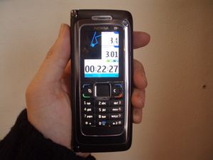 Nokia E90 running Sports Tracker Application The Nokia N95, N79, N810, E71, E90, 5330 XpressMusic, 5800 XpressMusic, 6220 Classic & 6110 (among others) have built-in GPS unit. It's useful have an up-to-date version of the Nokia software that uses AGPS to substantially speed up start up times (without the update, every time the GPS gets activated, it needed to perform a 'cold start' and download full almanac data from the satellites, which took several minutes).
According to Nokia, on the N95 you get the best reception by sliding the keypad out, then holding the phone upsidedown, so that the numeric keypad is at the top, and has a clear view of the sky. However, once the phone has a GPS lock, it's fairly good about holding it when you close the keypad, and hold the phone.
At least all Nokia smartphones based on Symbian S60 3th or 5th edition phones will communicate with external GPS devices using Bluetooth.
There are many free alternatives for capturing GPS tracks. You can also geotag photos taken using these phones using Nokia's free Location tagger software.
- MrGPS
MrGPS is an high-performance, compact, robust, comprehensive application which logs GPS tracks and provides real time statistics with voice aid. It produces GPX logs including track segmentation and waypoints.
The speech capabilities of MrGPS allow real-time hands-free assistance. Geotagging is also provided, with the possibility to quickly associate names to tagged positions.
To meet the widest customization requirements and address differentiated usage needs, MrGPS provides 240+ configuration settings through menus and property files.
MrGPS has specialized functionalities to monitor and report altitudes via visible and voice based alerts and can integrate applications to upload produced logs to your personal cloud storage.
MrGPS has many corollary functions, like automatic time GPS sync, configurable voice clock, astronomic calendar, system information tool and others.
Documentation: MrGPS
- Nokia Sportstracker
Download Sportstracker, a free GPS tracking program from Nokia research labs. It allows to record a trip and export it to GPX directly. The software page says it is compatible with the following phones: N71, N73, N75, N76, N79, N80, N80ie, N91, N92, N93, N93i, N95, E50, E60, E61, E61i, E62, E65, E70, E90, 3250, 5500 Sport, 6290, 6110 Navigator, 6210 Navigator, 6220 Classic.
To start recording, select New Workout, and then when you have a satellite fix, press Start. At the end press Options > Stop.
To save a route, select Training Diary, select the date, open the workout, then Options > Save workout > Export as GPX.
- TTGPSLogger
You can download TTGPSLogger, a GPS logger software for Symbian S60 3rd Edition(FP1, FP2) and 5th Edition. The GPS tracking log can be written in NMEA, GPX, or KML format by using Built-in GPS or Bluetooth GPS.
It is necessary to sign TTGPSLogger before installing it. Please read the documentation for details.
- WhereAmI
WhereAmI also works on Nokia Symbian phones. It shows your position on downloadable OSM maps but can also generate GPX trails and waypoints (text, numbered, photo and audio).
Nokia N95 (Smartphone)
- Good things
- In good conditions quite consistent position and tracks (in opened configuration without anything blocking the receiver that resides underneath the number keys)
- Produces OK tracks when using greater than walking speed (car, bus, bike, etc.), even within city areas with high buildings if traffic-lights won't stop you.
- Bad things
- Tends to "undershoot" on curves and requires tens of seconds to recover to the actual track (could have some stupid position correctioning instead of providing "raw" data). If possible, taking corners from both directions help to find the middle spot (I'm thinking of some way to auto-correct this phenomena -ij).
- Does not recover very soon from accumulated mis-position after a leg with bad quality.
- Inside of trains, I've had no luck in getting fix, get one before entering one (probably applies to busses too but I don't have enough data to say for sure as I always get the fixes before-hand nowadays).
- Walking speeds produce great wandering here and there, especially bad if something blocking or giving multi-path effects (much worse than with higher speed).
- Height readings are utter garbage, at least here in north.
Nokia N810 (Internet tablet)
 Nokia N810 showing slide out keyboard 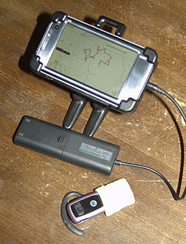 Nokia N810 with bluetooth headset, adapted mounting bracket, and external battery pack Nokia N810 is sold as an "Internet Tablet". It is a pocket size Linux computer with a built-in GPS, wlan and USB connectivity, Bluetooth, sound in/out, a not very useful camera, tiny but very functional keyboard, and a much higher resolution (touch screen) display than e.g. the Apple iPod Touch which is probably the main competitor (though not in our field because that doesn't have a GPS). It's 13×7×1.5 cm approx and comes with a car bracket (which can be adapted for bike handlebar mounting with some ingenuity). Note it *doesn't* include a mobile phone (though you connect through one using Bluetooth). As well as the 2 GB solid state disk, there is a miniSD card which makes storage expandable. You would be hard put to fill 8 GB of card with tracks, but voice notes run at about 60 MiB per hour.
It's comparatively expensive a solution, though no doubt second hand ones will start coming on the market in due course. However, if you are using audio notes (recommended, see below), the device can record these for you as well, so you don't need a separate dictaphone.
The use of the GPS is highly dependent on which software is used. At the moment, OSM mappers will want to install Maemo mapper. This records and displays tracks over a map background which is OSM's Mapnik by default. Unless started in the same place as it was previously stopped, the GPS/Mapper takes quite a long to to get a fix, but once it has it is nicely dense and apparently pretty reliable (though is just as vulnerable to woodland and tall buildings as other GPSs).
I (David.earl) have found a very efficient way to use it is with a Bluetooth headset (with the microphone covered with a bit of washing up sponge to suppress wind noise) to record continuous audio, and an adapted version of Maemo Mapper which provides for a single touch anywhere on the screen to make auto-numbered waypoints (so I can use gloves - essential on a bike in winter). The absence of wires is a big plus.
The battery life can be a problem. It is about 4.2 hours with the display on continuously (presumably this will degrade as the battery ages). Obviously you could carry a spare battery, but I bought a cheap AA battery cage which means I can power it on external rechargable NiMH batteries if the built in one runs out. 4 hours of urban mapping at one go is quite a long session anyway through.
On the whole it has been pretty reliable, but it has crashed once on me while surveying and meant I lost an hour's worth of tracks (I think I might modify Maemo Mapper to do a periodic autosave, but in the meantime frequent saves are recommended).
I don't think you'd necessarily buy this just for mapping, but if you want a mobile browser, media player, note taker, navigator, PDA etc, this could be a good solution for you. I certainly like it.
Footnote: Maemo Mapper currently seems to have a track limit of about 5 MiB in a single track. (AC7SS)
Nokia N800 (Internet tablet)
The predecessor to the N810, this device deosn't have a GPS. But used with a bluetooth GPS, you can get to use pretty much the same combination of software as the N810. The advantage is the much lower cost.
Progin T-368
- SiRFstarIII
- Trackpoints: max. 2 GiB SD/MMC card
- Weight: 100 g
- Connection: Bluetooth (speaks NMEA), mini USB (needs special cable)
- Price: €~90
- LC Display with blue backlight
- 75 mA power consumption @ 5 V DC
Unfortunately all SD cards in the image did not work on both two of these devices I had ordered. A new 2 GiB Transcend card however worked out of the box.
O2 (general)
O2 is a German mobile phone company. The PDAs labelled as O2 are mostly (or all?) produced by HTC and have a different name. If you know the name, please complete the list.
- O2 XDA Atom
- O2 XDA Atom Exec
- O2 XDA Atom Pure
- O2 XDA Comet
- O2 XDA Cosmo
- O2 XDA Exec
- O2 XDA Flame
- O2 XDA II
- O2 XDA IIi
- O2 XDA III
- O2 XDA IQ
- O2 XDA Mini (No GPS receiver integrated, but can be via Bluetooth)
- O2 XDA Mini S
- O2 XDA Neo
- O2 XDA nova
- O2 XDA Orbit = HTC Artemis
- O2 XDA Orbit 2 = HTC Touch Cruise
- O2 XDA star
- O2 XDA Stealth
- O2 XDA terra
- O2 XDA Trion
- O2 XDA Zinc
- Category:HTC users
Pentagram PathFinder P3106
Specifications according to the manufacturer:
- Chipset: MTK chipset
- Sensitivity: -158 dBm
- 51 channels
- Power: rechargeable Li-Ion battery (model: HX-N3650A, 850-1000 mAh) compatible with Nokia BL-5C
- Operationnal time: 25 hours
- WAAS+EGNOS+MSAS
- Auto On-Off function in NAV Mode, always on in LOG Mode
- Protocol: NMEA-0183 (v. 3.01)
The device can be set up and logs can be downloaded over bluetooth with the MTK GPS Datalogger Device Control Tool BT747 which can be used on Windows, Linux, Java Phones, PalmOS and WinCE.
BT747 info:
- Model: 0008 (iBlue 747)
- Flashinfo: 1C20161C (EON, 4 MiB)
- Firmware: B-core_1.1 (TSI_747CD)
- Logger-Version: 1.38
Battery life:
- Conditions: logging every 1 s, no BT, GPS not in move (fixed position).
- Battery included in set (model: HX-N3650A, 850-1000mAh): 25.5 hrs
- Original Nokia BL-5C (1020 mAh): 27 hrs
- Original Nokia BL-5CA (700 mAh): 17.5 hrs
Download time:
- with BT747, full download, ca. 25 minutes
Qstarz BT-Q818
Small bluetooth GPS mouse, reasonably priced at €85 (March 2007), excluding shipping.
Some specs as specified by the manufacturer:
- Chipset: MTK
- Internal antenna with built-in patch antenna with LNA
- Protocol: NMEA-0183 (v. 3.01)
- Bluetooth: V1.2, 15 metres in open space
- Bluetooth profile: SPP
- 32 simultaneous channels
- Sensitivity: -158 dBm
- Operational battery time: 32 hours (!)
- WAAS/EGNOS
- Auto on-off functionality
- Comes with two chargers; one for normal outlets and one for car lighter sockets.
- Good things
- Accuracy seems good enough for mapping streets in old city centers like, for example, Amsterdam and still get reasonable tracks.
- The somewhat extreme battery-life of 32 hours
- The auto-on/off function is nice; it goes to sleep when you don't use it (but, see bad, below)
- Aside from the two charging solutions, it can be charged off a normal USB connection (if you have the correct cable, it requires normal USB to mini-usb)
- Bad things
- This one may not actually be a problem with the device. It seems the auto-on/off function may sometimes interfere with proper operation of the unit, apparently depending on what software you use. I experienced lost connections while using it with Mobile Trail Explorer, resulting in traces that stopped before I actually wanted to stop logging. So, not good, that. On the other hand, using nmea_info.py, this problem seemed to occur less often and, more importantly, when it happened the software would notice and simply reconnect.
Might be the same device as Transystem i-Blue 747.
Qstarz BT-Q1000P Travel Recorder
It's a bluetooth GPS logger based on the MTK chipset.
Specifications according to the manufacturer:
- Chipset: MTK chipset
- Sensitivity: -158 dBm
- 51 channels
- Power: rechargeable Li -Ion battery compatible to Nokia BL-5C
- Operationnal time: 32 hours
- Support One Touch to turn On/Off LOG mode
- Up to 200,000 records
- WAAS+EGNOS+MSAS
- Auto On-Off function in NAV Mode, always on in LOG Mode
The device can be set up and logs can be downloaded over bluetooth with the MTK GPS Datalogger Device Control Tool BT747 which can be used on Windows, Linux, Java Phones, PalmOS and WinCE. With this Software the Qstarz can be configured to log at up to 5 Hz!
Qstarz BT-Q1000X Travel Recorder
It's a bluetooth GPS logger based on the MTK II chipset. mtkbabel works fine with this device.
Qstarz BT-Q1200 Solar Travel Recorder
This is also referred as Super 99 Bluetooth GPS Travel Recorder.
 BT-Q1200 Solar Travel Recorder It's a bluetooth GPS tracker based on the MTK chipset. The small solar panel on the front of the device helps to preserve the battery.
Specifications according to the manufacturer:
- Chipset: MTK chipset
- Sensitivity: -158 dBm with fast FFTT
- 51 channels
- Power: Dual Power Supply - Built in rechargeable Li -Ion battery & Solar power
- Operationnal time: 48 hours (using the solar panel)
- Support One Touch to turn On/Off LOG mode
- up to 200,000 records
- WAAS+EGNOS+MSAS
- Auto On-Off function
The good news is that this device is perfectly working with linux using the BT747 tool.
Note that this device has a smaller patch antenna than the BT-Q1000 models which may impact sensitivity.
See the review at gpspassion
Qstarz BT-Q1300 Nano
- Chip: MTK
- Channels: 66
- Sensitivity: -165 dBm
- WAAS, EGNOS, MSAS
- Memory: 200,000 datapoints, can log 1Hz, Internal 4 MiB
- Product Page
BT747 is compatible with the BT-Q1300 too.
Ricoh 500SE
- GPS-ready digital camera with Bluetooth and wlan.
- Integrated GPS module.
- Alternately, the camera accepts NMEA data from external Bluetooth-enabled GPS devices.
- User-defined data-dictionary for tagging the media with workflow-related information.
- Keep memos as part of your photo information.
- Waterproof, shock-resistant.
- Price will be GB£549.99 and GB£599.99 wlan version.
RoyalTek
- Article principal : Royaltek
Scytex NaviGPS / Locosys (B)GT-11
- Article principal : NaviGPS
- Price: without Bluetooth: GB£65, (€94 as at Sep. 2006), AU$199
- Price: with Bluetooth: GB£76 (€112 as at Sep. 2006)
- Both the standard and Bluetooth versions of the NaviGPS are available in the UK from Storage Depot. Storage Depot will donate 10% of the purchase price to OSM if you buy a NaviGPS from them – see Shop for details. Storage Depot are now (as at September 2006) supplying the Locosys GPS Tracker GT-11/BGT-11 version – this is identical to the Scytex NaviGPS other than the text on the device says GT-11/BGT-11 instead of NAViGPS. Notice: If you order at Storage Depot the device is delivered without a cycle mount, without an arm strap and with a UK (non Europe) 240 V adapter. Storage Depot offer the cycle mount as an option for GB£6.
- The Bluetooth version is available in Canada from GPS Central.ca and Mobile GPS Online.
- In the Netherlands, the product is known under the name Amaryllo Trip Tracker. check www.amaryllo.com
- Check the Scytex website for other worldwide distributors.
- 12 channels.
- SiRFstarII
- 8,192 trackpoints (6,000,000 trackpoints using optional 2 GiB SD memory card).
- Stores up to 1 month – ½ year of tracks on 2 GiB SD card.
- Made for: biking, jogging.
A compact GPS with basic navigation capabilities and data logging. No facility to display a map.
The GPS performance seems to be acceptable. It makes a nice bleep and flashes a red light when it achieves lock-on which is nice and reassuring.
The unit is solid, well constructed and quite compact. It is waterproof (useful if it rains, or for other forms of wet mapping) It contains a non-replaceable rechargeable li-ion batteries with a maximum battery life of 32 hours. The standard version comes with a car charger as standard. Both models have a USB serial connection for upload and recharging. The ability to recharge via the USB cable is a very nice feature. It also comes with a standard adaptor for recharging from a car and the most compact and nifty 240 volt mains adaptor I have ever seen.
The screen is small (33×21 mm; 128×64 pixels) but quite readable in daylight with mostly clear displays. The status symbols on the right of the screen (2D/3D, battery indicator, etc.) are quite small and hard to see (with my eyesight). The backlight is red which is a bit unusual (maybe it's intended to preserve night-vision?). It is easy to accidentally set it permanently on, or permanently off, rather than the default auto-off mode.
It has only 2 buttons for operation: an On/Off/Escape button and a joystick-like button for menu navigation. The joystick can be operated, albeit a bit clumsily, while wearing thin gloves and riding a bicycle. Not sure if it would be possible while wearing very thick gloves (eg ski-gloves).
The manual comes as a PDF document on a CD, or can be downloaded (see below). It is well written (for a Taiwanese user manual), and runs to 66 pages. The editor's introduction is written from the heart and is a nice touch.
It has all the standard basic GPS features: routes, waypoints and track-logs (but no map display). A trip meter is provided that is clearly designed for the cyclist. It also has configurable alerts for speed, altitude and destinations which some people might find useful.
It comes with a simple Windows application for uploading/downloading routes, waypoints and trackpoints. Installation of the USB serial driver was a bit fiddly, but otherwise it works fine. In the software "Version 1.1 B20060228" there are two main download options (Oziexplorer/GPX/CSV and Waypoint+) in addition to the raw NMEA files. This software version also uses GPSBabel to export the data in KML format suitable for use with Google Maps and Google Earth. There is a backup/restore function which creates a 512k binary file which I suppose is a dump of its flash memory.
For Linux users, the Windows application appears to work OK using wine. The USB interface on the device is supported by the pl2303 driver and appears as a serial port (e.g. /dev/ttyUSB0) providing raw NMEA data for gpsd or gpsdrive. Some further Linux information is at NaviLink for Linux. This page includes a link to a page describing a Perl script that can be used in place of the Windows program provided with the device.
It can record 8,192 track points in the built-in flash memory at "compact", 1, 5, 10, 30 and 60 second intervals.
- Track logs
It has a slot for an SD memory card which records tracks in NMEA format. A new log file is started as soon as the device is turned on and records continuously.
We assume a:
- maximum NMEA string has ~500 Bytes/s and a minimal NMEA string has ~100 B/s.
- ⟶ 0.5-2.7 hours/1 MiB.
- ⟶ 2,000-10,000 Trackpoints/1 MiB.
- ⟶ 2-10M trackpoints/1 GiB SD card.
- ⟹ 500-2,700 hours of pure tracks/1 GiB SD card.
- ⟹ 2.5-14 month of complete tracklogs (1 s, 2 GiB card, 12 h/24 h)
The SD card track log data can not be read via the USB cable. You need to remove the card and use an external card reader.
Initially the device failed to write any data to my SD card but it worked fine after selecting the "format card" option. The same card had been working fine in a digital camera so perhaps the NaviGPS is a little fussy about the formatting of the card (that's probably because the NaviGPS expects the card to be formatted without a partition table and will not use the card if it contains one).
To convert the track logs from NMEA to a format usable by openstreetmap, see the NMEA page.
- Good Things
- Good for cyclists (Notice: cycle mount and arm strap not included if ordered at Storage Depot)
- Price!
- Waterproof
- Lightweight & compact -- can be stuck on helmet with velcro dots alone (suggest extra string for safety)
- Very robust (mine has survived several drops and considerable rough handling)
- 8k trackpoints internal Memory (750k trackpoints using 256 MiB SD card)
- Rechargeable battery
- Rechargeable via USB cable
- User manual is humorous
- Bad Things
- Backlight - can be left on accidentally
- Status icons - can be hard to read
Only available in UK, Canada, Russia, Taiwan, Australia- Bike mount not very strong (mine broke, unit fell onto concrete at 20 mi/h)
- Doesn't do negative altitude, just reads 0ft (tested in Death Valley!)
- Waypoint names can only be 6 characters long
- Does not make tracklog points based on distance. (only if using old firmware)
- Nonreplaceable battery (if out of civilization for a while)
- Summary
Seems to be ideal for the cyclist capturing tracklogs for OSM. Excellent price.
- Manual
The PDF manual for the NaviGPS is available from the Scytex website; the manual for the GT-11/BGT-11 is available from the Locosys Technology website (these manuals are essentially identical).
- Owners Notes
The NaviGPS page contains notes about the operation of the unit.
- Getting Routes from Google Maps
I have written a simple Perl script for grabbing routes from google maps in KML, and converting/saving them to .wtp/.rte format. The usage is:
> gmap2ozi.pl [ routename ] [ postcode 1 ] [ postcode 2 ]
This could be made more generic quite easily — it is just a first stab! I wrote it out of frustration at my inability in getting useful information onto the device.
It is available at http://ave.wrigley.name/gmap2ozi.pl.
Scytex NaviGPS / Locosys (B)GT-31
- Article principal : NaviGPS
- Availability
A new NaviGPS was announced at CES 2008, featuring a SiRFstarIII chipset. It became available for sale in May 2008. Manufacturer-provided documentation is available here.
- Downloading Tracks
The GT-31 saves tracks to its internal SD card in a binary format (depending on the setting, the data are either NMEA or SBN). GPSBabel is capable of converting this via the "navilink" option (-i navilink), which currently does not appear in the OS X GUI version. Users will need to use the Terminal to access this functionality (see Beginner's guide for a detailed explanation).
Sony GPS-CS1
The GPS-CS1 is a small and lightweight unit that runs on one AA battery (10 hours) and stores data (NMEA text files) on its internal memory (about 32 MiB). Memory is then accessible as a standard USB key by any OS with USB mass storage capabilities. Costs around €100.
The GPS-CS1 was originally conceived to georeference digital pictures in accordance with their timestamp. Thus, it assumes pedestrian motion, and records a position every 15 seconds or so. This results in a very good sampling rate when you walk, but is less optimal when you drive your car or ride a bike - especially in a city.
Accuracy is honest (around 5 meters in average conditions) but sensitivity is not good. That and the 15 seconds sampling interval make it a very bad choice for urban work on anything faster than walking. But for simple rural roads it works well.
Reviews :
Sony Clie N series
This review is based on a sony Clie PEG-N770C/U. The Sony Clie N series is a low spec PDA which runs the Palm OS.
The Sony Clie N series has no inbuilt GPS reciever or CF card slot.
However it can plug in to an external GPS receiver such as the Haicom HI-203E.
The GPS receiver needs to be powered, and the Haicom comes with a combined cable which connects the PDA, the receiver, and plugs into a car lighter socket to power the receiver and the PDA.
(If you are adept with a soldering iron, you could also make a portable battery-powered adapter).
The freeware Cetus GPS software can record track logs, in its own proprietory format, which can then be converted to GPX tracks using either GPS Babel or GPS TrackData.
Sony PSP (Playstation Portable)
...
SparkFun Logomatic Serial SD Datalogger & EM-406 Receiver and usb breakout board
- Good things
- Uses SD cards
- As compact as you make it
- Can be used as a USB puck GPS receiver
- Has lots of blinking lights
- Antenna built in
- You get to do some soldering
- SD logger configuration through a text file on the SD card
- Not terribly expensive
- Output works well with gpsbabel and osmfilter
- Bad things
- You get to do some soldering
- No display, purely a data logger
- Needs a few components:
- Receiver
- Data logger
- USB breakout board (not truely needed, but quick and useful)
- Case for mounting components
- Seems to have a bit of jitter when stationary. However, this can be tidied by osmfilter
- Summary
- With a bit over 10 hrs of battery life from 4 NiMH AAs, this set up is more than enough for a day of driving. A kit box that fits the set up perfectly is a bit hard to find, so it would be best to build your own. Useful if you are after something you can just turn on and forget about.
All the data can be logged to NMEA in plain ASCII files, which are quite small.
Thales Geomatics
See Magellan Professional.
TomTom
 TomTom Go with additonal Logging Software Main article: TomTom and Event Logger
Transystem i-Blue 717
My package didn't say it was a Transystem device, but it seems to be one.
This small device works well with PCs and Mobile Phones. It is only a GPS mouse, so there is no setup or configuration.
It has the same features as the Qstarz BT-Q818, so you might want to read its reviews, to, which is also found on this page. It also appears to be identical to the BlueNext BN-800GR.
- Good things
- Very cheap (€30, eBay, Nov. 2007)
- Smart Standby mode: In standby, battery will last more than two weeks. You can wake it up by simply connecting by bluetooth, after disconnecting it will go back to standy.
- Has a hard switch to completly power down
- Charged over a mini-USB connector (but no data transfer over USB)
- Replacable LiIon battery which is compatible with many Nokia cell phones
- Connector for external antenna
- Bad things
- Accuracy may typically vary between less than 1 meter and about 10 meters. With bad weather, even 60 meters and connection losses may occur.
- While it gets a fix after 20-30 seconds when standing still, it takes up to 5 minutes when moving, even if you are only walking slowly. When driving car or bike, reconnecting may be impossible.
- My mouse (the same) fixes also fast when driving or moving.
Transystem i-Blue 737
- Bluetooth GPS
- Mediatek (MTK) chipset
- 1 Hz (5 Hz via hack, requires opening)
- Charge via USB
- 23 hours battery time according to review: Full review
- Links
Transystem i-Blue 737A+
...
Transystem i-Blue 747
- Price: €55
- Bluetooth GPS + Datalogger
- Mediatek (MTK) chipset
- Charge via USB
- You can configure which GPS data gets logged into memory
- before: 16 Mibit (2 MiB) memory (± 60000 track points - depending on what is being logged)
- new: 32 Mibit (4 MiB)
- Size: 46.5×72.2×20 mm
- Weight: 67 gramms
- Original Windows Software, works fine with wine on Linux
- BT747: Java Software for all OS, useful for the 5€Hz hack
- MTKBabel, Perl command line tool for Linux and *BSD
- Mac Travel Recorder, nifty GUI for MacOSX
- WinGPSLogger: Splits tracks in so-called trips, generates GPX including manual waypoints, for Windows
- Full review
- Comparison with Wintec WBT-201 (German/Deutsch)
- MtkDLut Free alternative software (Windows) to setup and readout loggers using the MTK chipset such as the i-Blue 747. More reliable than the soft that comes with the device!
- Linux usage
The device can easily be used in Linux too; e.g., using BT747. I had a little trouble setting it up, so I decided to give a little explanation on how to use it in Linux:
First you need to load two modules, usbserial and cp2101 which are included in kernel 2.6.20 (probably earlier versions too, didn't check it). If the device gets plugged you'll get a device like /dev/ttyUSB0 to access your device (don't forget to give yourself permissions accordingly). The device has to be in LOG mode. It gets recognized in the other modes too, but didn't work! In case you use gpsd use
gpsd -p /dev/ttyUSB0
I don't understand why but it didn't work without the "-p" switch, although the man pages states it. Hope that helped, have fun with the device ;)
- Links
Transystem i-Blue 747A+
- Linux usage
Works since linux kernel 2.6.29 with driver cdc_acm.
For earlier kernel versions have a look here.
Transystem i-Blue 757 Pro/iTrek Z1
- Bluetooth GPS+ Datalogger
- Mediatek (MTK) chipset
- Solar Panel
- US$69 on semsons.com
- Autonomy: 30 h/up to 100 h with solar panel
- Charge via USB
- packaging: a usb retractable cable, a grip, a car charger and a battery.
- 1 Hz (5 Hz via hack, 5 Hz logging works)
- 8 Mibit memory (±50000 track points)
- Original Windows Software
- BT747: Java Software for all OS, useful for the 5 Hz hack
- Full review
- MTKBabel, Perl command line tool for Linux
- Recommended use
It's a good datalogger for osm under *NIX. You can have long journey with it thanks to his panel and its good battery... unfortunately, the memory can't be extended and it's limited to ~50,000 points (14 hours at 1 Hz). You can use it in a car or in bike... where you will have to take some care about it's realy poor plastic.
The best util under unix seems to be mtkbabel, which fetch data and produces GPX files.
- Good Things
- You can at same time log on the itrek and use it as a GPS antenna to a laptop/phone. Usefull to follow your location with GpsMid while mapping.
- Quite cheap
- Real good autonomy with and without solar panel
- A lot of settings that you can tune
- A realy good and simple line-command utility (mtkbabel) to fetch the data.
- Common battery (same as Nokia phones)
- Bad things
- Cheap plastic, buttons and articulations
- No memory extension slot
- Not suitable for walking - inaccurate results
- Hardware bug that prevents to transfer data unless placed in "logging" mode.
- No ability to just charge the battery via the panel, should be running to use it.
- Included software does not support GPX
Transystem i-Blue 821
- Price: €~70
- Bluetooth GPS + Datalogger
- Mediatek (MTK) chipset
- Charge via USB or car cigarette lighter
- You can configure which GPS data gets logged into memory
- Memory: 32 Mibit (4 MiB) (up to 150,000 track points)
- Size: 93.5×46×10.8 mm
- Weight: 49.5 g
- Battery: built-in 750 mAh Lithium battery (5 V)
- Autonomy: 18 h (stand-by: 250 h)
- Update: 1 Hz
- Bluetooth range: up to 15 m (class II)
- MTKBabel, Perl command line tool for Linux and *BSD
- oficial page
- Good things
- Logs and gives the position at the same time
- Works out-of-the-box with mtkbabel (tunable)
- Lightweight, ultra-slim form factor
- Not really expensive
- Very good chipset, good accuracy (even when kept in a pocket)
- Good battery life, smart power saving function, smart auto sleep & wake up mode
- Simple to use
- 4 useful LEDs
- Seems not so fragile
- Bad things
- No waypoint button !!!
- No memory extension slot
- No external antenna connector
- No display (of course one may e.g. use some J2ME stuff on a phone with Bluetooth enabled, see http://www.veloxgps.de/, not to mention navigation software with maps etc.)
Transystem i-Blue 887
- Sold as photoMate
- Very small logger
- Bluetooth and USB connection
- Under Linux I have connected via bluetooth using mtkbabel. Connection via USB with a 2.6.27 kernel results in identification as requiring module cdc_acm, but no connection.
A 2.6.30 kernel allows connection via USB and then works with BT747 download here website.
Gentoo users can emerge sci-geosciences/bt747.
Wintec/Woxter (general)
Please see the dedicated sub-page: /Wintec and Woxter
Xaiox itracku
- Nemerix 16 channel chipset
- 20 h working time
- Automatic off/on (done by integrated shock sensor)
- 250,000 points
- Pure software interface for Windows only
- Integrated Li-ion battery
- Connection & recharge: USB
- Bluetooth interface for navigation software
- Price: €~100 (http://www.wcom-gps.com)
- xaiox product page
- Linux download program [7]
Xaiox Marathon
- Nemerix 16 channel chipset
- 24 h working time
- (rechargeable) AA-Battery or 5 V DC input (no recharge, USB power supply adaptor included)
- Bluetooth interface for navigation software
- Price: €~50
- xaiox product page
Xroad V4150
- SiRFstarIII Chipset
- 4.3 in touch screen
- Application/Map storage on removable 2 GiB SD-Card
- Inbuilt recharable Batter
- Bluetooth connection for hands free cellphone.
- Media player (MP3 and xVid)
- Can be hacked to run other applications (underlying OS is Windows CE 5).
- Street price: US$160
I nice little unit, seems to work quite well. Tracks stored in an internal database, can be exported to '.GPX' with 2 second positons (although missing elevation info). Comes with 2 GiB card with either North America or European maps.
Zaapa ABTG-7000
- Good things
- Cheap
- Small
- External antenna connector
- Bad things
- May hang up
- Takes very long to get a fix
- Poor accuracy
- Summary
The poor accuracy of this cheap GPS receiver will make your GPS traces quite erratic. You'd better save €30 more and go for a better model if you want to get good traces
|


