TIGER fixup
| United States | openstreetmap.us | Projects | Tags | TIGER fixup |
|---|---|---|---|---|
| OpenStreetMap US | Users | Data Imports | Resources | Category |
The TIGER data imported in 2007 serves as a great foundation for the mapping of highways, railways, and other significant map elements in OSM. However, the imported elements had various mapping and tagging inaccuracies. These inaccuracies do not reflect their real-life counterparts and must be fixed.
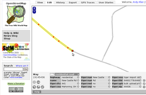
All TIGER elements were imported with various TIGER source tags and the signature tiger:reviewed=no tag. An OSM element from the TIGER import is considered "fixed" when the tiger:reviewed tag is removed. See Review to determine when you should remove these tags. There is no consensus at the time.
Tagging
Each TIGER element has a set of standardized attributes. These attributes were then converted to related OSM tags for the import.
Some of the original tags are not as accurate as OSM tagging conventions. Therefore, they need to be fixed.
Wrong highway classifications
Most highways imported from TIGER were classified as highway=residential. In many instances, highway=residential is not the most appropriate tag. This problem is most common in areas with little editing since the TIGER data were imported and/or in rural areas.
Explanation
OSM typically has three highway classifications (tertiary, unclassified, residential) where TIGER had one class (A40 group, especially A41).
Fix
Tag incorrect highway=residential ways as rather:
- highway=tertiary (paved through road, often with centreline)
- highway=unclassified (minor country road)
- highway=service with service=driveway or service=parking_aisle (driveways and parking aisles, respectively)
Tertiary and unclassified roads are assumed to be paved in Western countries, so make sure to add a surface=* tag if the road is in fact unpaved.
Road names
TIGER uses USPS abbreviations in road names, whereas OSM does not. emacsen used a bot to expand many abbreviations in December 2012, but some remain.
Explanation
In the TIGER database, road names are in uppercase, so to indicate mixed-case names, TIGER adds a space. For example, "MacDonald Street" was imported as "Mac Donald St" in TIGER and remains that way in more recent TIGER overlays. Mixed-case names commonly occur with prefixes such as "Mc", "Mac", and "Van". TIGER uses only A–Z and 0–9 in road names, so apostrophes become spaces ("O Toole Avenue" instead of "O'Toole Avenue" or "O’Toole Avenue"). Likewise, French and Spanish diacritics, such as the ñ that is standard in California, are stripped off ("Canada Road" instead of "Cañada Road").
Fix
Use street-level imagery to confirm the signposted spelling. If a mapper has changed the spelling since the TIGER import, ignore the spelling in TIGER.
Other
Other tagging problems include:
- missing ref=* on highways
- using obscure or outdated names for Places rather than common names
- highways missing oneway=yes on each direction of dual carriageway
- railway=rail where its name=* is better tagged as owner=* or operator=*
- long stretches of railway=rail that remain unreviewed often don't denote actually existing bridges, viaducts, cuttings or tunnels
Mapping
The mapping, or geographic placement of OSM elements from the TIGER import, is incorrect due to a variety of inaccuracies from the initial TIGER data.
Road Alignment
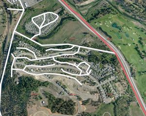
Probably the biggest problem with TIGER data is that they were originally created for taking census surveys, not for making maps. This means that in many areas the roads aren't aligned with their true position, but if you imagine the TIGER database as a sketch for people walking around with clipboards, then it has all the roads laid out roughly correctly. The work then needed is to drag everything into its correct place and add more nodes to smooth out curves.
Fix
Map the roads accuratly using up-to-date aerial imagery and/or GPS tracks.
See TIGER fixup/Alignment for how to fix, and a list of counties with widespread problems.
Connectivity along county borders
The majority of county border connectivity errors have been fixed, including partially overlapping ways.
Explanation
In many instances, ways crossing county boundaries may stop at one side of the county border, when they continue into an adjacent county, or the gaps in the ways at the county border are so large that simple connectivity checks will not identify them. Visual inspection of county borders may still identify these sorts of errors.
Problems
There are particularly serious data problems along county lines, where different TIGER datasets were imported.
The main problem is that each county import didn't "know" about adjacent neighbours, so they created duplicate nodes where the end of a road meets the start of its continuation (or "twin brother") from the next county. This affects major highways and prevents Routing between counties.
Other problems include overlapping roads and border ways - for example, when a road runs along the border it will have been uploaded twice in exactly the same place - once from one county and once from the other.
Fix
Connect ways that have disconnected by county borders. Delete overlapping and duplicate ways.
See TIGER fixup/County borders for how to fix.
"Over-Connectedness"

The original TIGER data had no concept of whether two ways are connected or not, so that was all synthesized during the import into OpenStreetMap.
Explanation
Grade-separated ways, or roads or railways that go over each other at different heights, are sometimes connected. This causes problems when routing and reflect intersections that do not exist.
Fix
Remove the nodes shared by the two disconnected ways and specify their respective level=* along with adding any bridges or tunnels.
See TIGER fixup/Over Connectedness for how to fix.
Divided roads
Many Interstates and other major roads only have one carriageway (highway) in TIGER, when in reality, they have two one-way carriageways ("divided road" or "dual carriageway").
Fix
Create another way representing the highway in the opposite direction and align each of them to the centerlines of their roads. Add oneway=yes for each and verify their directions.
See TIGER fixup/Divided roads for how to fix.
Simplify ways with excessive nodes
Highways in some rural areas were imported with many nodes.
Fix
JOSM and Potlatch users can use the Simplify Way Feature to eliminate excessive nodes without losing any characteristics of the road. This feature is very useful in rural areas where roads tend to be straight. After using on a way, be sure to verify that no characteristics of the road were lost.
There is currently no tool to simplify ways in iD.
Braided streets
The vast majority of these have been fixed.
Explanation
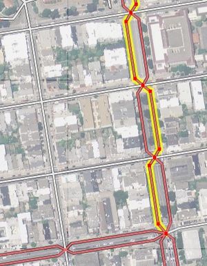
Some streets in the TIGER upload were "braided", where the one-way highways of a dual carriageway criss-cross back and forth across each other, sometimes going in the wrong direction for the side of the street on which they run. The ones that were identified shortly after the upload were fixed using the osm-unbraid tools.
Note
"braided" refers only to the situation where the ways are indiscriminately on the wrong side of the street for their direction. It is a reasonable and well-used technique to bring the ways of dual carriageways back to a single point at intersections to facilitate and simplify the mapping of control devices and turn restrictions. In other words, you may see situations that look similar to the picture, but are correct because the ways both stay on the correct side of the center divider between intersections. In all cases, like any other edits in OSM, be careful not to lose any existing correct data contributed by your fellow mappers.
Fix
Split the braided ways at the nodes where their actual direction changes. Use oneway=yes and verify the direction for each way split.
Other
Other mapping problems include:
- entire roads that no longer or never did exist (especially in rural areas)
- whole subdivisions misplaced by dozens of meters
- missing subdivisions (may be available to be traced with TIGER_2012 Imagery)
- bridges and tunnels are not added
Review
Fixing and reviewing the elements and their tags that were part of the TIGER import is an important step in ensuring the quality of the OSM database. Once all of the TIGER elements are reviewed, the TIGER fixup should be considered complete.
When to remove tiger:reviewed
The choice as to when to remove the tiger:reviewed=* is ultimately up to the mapper.
It is recommended to remove the tag after a combination of several, or all of the following elements have been verified.
- The road exists in reality
- The road geometry is accurate
- The name of the road is correct
- The surface of the road is tagged
- The classification of the road is correct
- The road no longer has any other tiger:* tags
Other tiger:* tags
Consensus has moved to recommending removal of tiger:* tags, since they provide no useful metadata. [1][2]
The tags present on OSM data no longer consistently match the data that was initially imported, and updated data is available directly from Census. It is safe to remove the tiger:* import tags from OSM data.
See also: TIGER to OSM Attribute Map.
Discussions
- "When to clear tiger:reviewed?" newbies mailing list
- "GARBAGE imported from Tiger" OpenStreetMap Help Question
- "Best practices for dealing with old TIGER tags?" Talk-us mailing list
- "Drop tiger:reviewed from roads" forum post
- "obsolete TIGER-tags" GIS forum post
- US Community: Tiger Cleanup - Tags
Useful tools
MapRoulette
MapRoulette (maproulette.org) is a micro-tasking/gamification system with several challenges related to TIGER fixup.
Overpass
These Overpass queries show which areas of data have not been changed since the initial import. Similarly, Sophox can query for the most untouched counties and the most untouched ZIP codes.
TIGERMap
TIGERMap will show all OSM items with tiger:reviewed=no. There are additional overlay layers (ex: railway=rail, man_made=pipeline) provided to help mappers find areas of interest to them.
Editors
iD
In ID, you can select TIGER Roads 2017, 2018, 2019, 2020, and 2021 as Overlays.
JOSM
In JOSM, unreviewed TIGER data (that is, with tiger:reviewed=no) used to show up with a yellow-ish background. It no longer does. This feature is still available as a mappaint style available here
Other handy fixup plugins include the WayDownloaderPlugin.
JOSM also has access to the same imagery overlays for updated TIGER road data as iD.
Strava
osm.cycle.travel shows unreviewed rural residential roads (in blue) that have been ridden over by Strava users, implying that they should be reviewed
TIGER
See the TIGER 2012 page for details of a tile set which you can load in as a background while editing.
MapJumper
You can jump from one slippy map to another, keeping the same position, with the mapJumper bookmarklet. Two ways :
- Just drag the mJLite bookmarklet on your tool/favorite/bookmark.
- On a well formed url map (with lat, lon, zoom), by clicking on your mJLite bookmark, you will be led (in a new window) to the mapJumper hub page where are proposed survey links.
- Just compose your bookmarklet here, with the preset import or survey. Paste the code in a new bookmark. Name it, let's say, mJ[Tiger] (you can get other mapJumpers).
- On a well formed url map (with lat, lon, zoom), by chosing the mJ[Tiger] bookmark, give the shortkey for the Tiger fixup service (tf). Validate and jump.
Old tools
These old tools were useful once, but are no longer available (could be inspiration for new developments?):
- The TIGER Edited Map ([1]) shows which areas of data have been changed since the initial import
- TIGER Battlegrid used to show yellow patches where most fixup work is needed, based on comparison with TIGER 2012.
- Duplicate nodes map used to show a map of this specific problem, which is a good indicator of problematic imported data.
- The To-fix tool used to have a have a 'tigerdelta' task queue (was running here) which looked at comparison issues with the TIGER 2014 dataset. The Mapbox data team (e.g. those based in peru) were using this in 2015 to fix many errors. See the commentary on this issue: https://github.com/mapbox/mapping/issues/100. It's not clear if there are more detectable deltas to queue up, or if they fixed them all.
- Waychains analysis ([2]) is no longer updated so not really useful. It used to reveal some bugs in the major interstate connectivity (hopefully mostly fixed now anyway)
Automated edits
Editors
iD and JOSM both discard some TIGER tags on elements that have them and have been edited in some way. You can configure JOSM to discard additional tiger:* tags in the tags.discardable section of advanced settings.
As of November, 2020, the following TIGER tags are discarded in iD:
| "tiger:upload_uuid" |
| "tiger:tlid" |
| "tiger:source" |
| "tiger:separated": |
As of November, 2020, the following TIGER tags are discarded in JOSM:
| "tiger:upload_uuid" |
| "tiger:tlid" |
| "tiger:source" |
| "tiger:separated": |
Bots
In December of 2012, emacsen ran an automated bot to clean up the TIGER abbreviated street names on the Eastern half of the US, along with cleaning up some of the spacing on the Western half of the US. Code at https://github.com/emacsen/tiger-expansion
In 2013-02 jjaf.de did wikipedia=* correction in Mechanical Edits/jjaf.de#WIWOSM TIGER import fixup.
