Tag:historic=wayside_cross
 |
| Description |
|---|
| A historical cross along a way, symbol of christian faith. |
| Rendering in OSM Carto |
| Group: historic |
| Used on these elements |
| Useful combination |
|
| See also |
| Status: de facto |
| Tools for this tag |
|
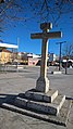
A wayside cross is a (mostly) historical (usually Christian) cross. Frequently found along the road in most Europe: Germany, Austria, France, Italy, Poland, Ukraine and other predominantly Catholic and Orthodox Christian countries.
- Use man_made=cross for a cross with no historical context and possibly even without religious relationship.
How to map
Draw a node at the location of the wayside cross an add historic=wayside_cross.
Tags used in combination
- name=* if it has a name
- religion=christian
- denomination=catholic or denomination=orthodox
- inscription=*
- material=*
- tourism=attraction if it's a tourist attraction
- start_date=* errection/sacrification date/year
- support=* mounting point<<!what it means in case of point tagging?>>
Tag history
historic=wayside_shrine, historic=wayside_cross were put in the historic=* key because they are seen as generally related to history, but this choice was never meant to exclude more modern wayside crosses and wayside shrines. As a result, this tag has always included wayside crosses that are not historic when applying a strict reading of the term. Sometimes, the tag has also been applied to crosses that are not located along a way (these should be retagged).
The tag man_made=cross is available for all kinds of crosses and doesn't have a wayside-requirement.
Photos


Schäderkreuz, Vienna


See also
- man_made=cross for other crosses
- summit:cross=yes attribute for natural=peak
- historic=wayside_shrine for shrines along a way.
- historic=high_cross
- historic=market_cross
- amenity=place_of_worship and Taginfo-values for place_of_worship:type
- wayside cross on Wikipedia