Tag:tomb=table
 |
| Description |
|---|
| A table tomb. |
| Group: historic |
| Used on these elements |
| Requires |
| Useful combination |
|
| See also |
| Status: proposed |
| Tools for this tag |
|
A table tomb is a table-shaped tomb built above the grave and supported by a series of pillars. It is common to find an inscription about the deceased on the surface of the table. This type of tomb was popular during the colonial era.
How to map
Place a node ![]() in the middle of the table tomb or draw the outline
in the middle of the table tomb or draw the outline ![]() of the tomb.
of the tomb.
Add historic=tomb + tomb=table.
Tags to use in combination
Sample photos
-
 A table tomb at the English Cemetery in Málaga, Spain.
 -
 A table tomb in Prestwich, England.
 -
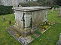 A table tomb in Hampshire, England.

