England Cycling Data project
From OpenStreetMap Wiki
(Redirected from DfT Cycling Data 2011)
Jump to navigation Jump to search
Cycle routes, cycle lanes, and other data.

The England Cycling Data project aims to incorporate open data on cycling infrastructure released by the UK's Department for Transport into OpenStreetMap. This is available as a background layer in Potlatch2, which has a merging tool enabling this to be merged in by manual inspection.

The data includes cycle routes, surface types, widths of cycle lanes, presence of lighting, cycle parking, and so on. The CycleStreets routing engine (used for CycleStreets & various apps) takes these into account and hopefully others plus renderers will too.

The project is being coordinated by CycleStreets and Gravitystorm.

Merging into OpenStreetMap - data now available

The data is now all available (June 2012), so please do help out with your area!

* The merging tool is now available!
* Screencast showing the tool
* Discussion on talk-gb and later discussion
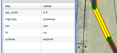
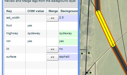
Inspecting the tags on a background feature
Merging tags from the background layer into OSM

The merging process works as follows:

  1. Click 'Map style' > 'Wireframe' to make things much easier to work with.
  2. The background data is highlighted either orange (needs attention) or blue (already processed).
  3. Click a background feature to select it.
  4. Ctrl+click (or cmd+click on a Mac keyboard) the relevant OSM feature to see a side-by-side comparison of the tags.

You can now review the tags, copy whichever ones are relevant, and mark the background features as complete if there's no more information to reconcile.

Data viz maps

Here are some ITO maps that show the data in OSM. This data may have been imported using this tool or manually surveyed, especially for areas where there is no data:

  • DfT cycle data simple [1]
  • Cycleway and footway widths [2]
  • Cycleway segregation [3]
  • Highway lighting [4]
  • Cycle parking dots [5] Cycle parking heatmap [6]
  • Road surfaces [7]
  • Traffic Calming [8]

Also a map created by Richard Mann: http://www.transportparadise.co.uk/dftcyclelanes/

A Taginfo instance showing the DfT cycle data: http://dft-cycle.taginfo.smsm1.net/

Links to the data, and main contact for each area (please add yourself!)

The data Progress of each area Contact person for the area (please do add yourself!)
Cambridge data Cambridge stats Martin, CycleStreets
Avon area ('CUBA') data Avon area ('CUBA') stats ?
Devon data Devon stats ?
Mendip data Mendip stats ?
Nottingham data Nottingham stats ?
SouthSomerset data SouthSomerset stats ?
TauntonSedgemoor data TauntonSedgemoor stats ?
Barnsley data Barnsley stats ?
Bedford data Bedford stats ?
Birmingham data Birmingham stats ?
Bradford data Bradford stats ?
Calderdale data Calderdale stats ?
CentralLondon data CentralLondon stats ?
County Durham data County Durham stats ?
Coventry data Coventry stats ?
Doncaster data Doncaster stats ?
Dudley data Dudley stats ?
Gateshead data Gateshead1 stats ?
Kirklees data Kirklees stats CompactDstrxion
Leeds data Leeds stats ?
Luton data Luton stats ?
Manchester data Manchester stats ?
Merseyside data Merseyside stats ?
MiltonKeynes data MiltonKeynes stats Mappermondo Chris
NorthTyneside data North Tyneside stats ?
Northumberland data Northumberland stats ?
Portsmouth data Portsmouth1 stats Robbieonsea
Rotherham data Rotherham stats ?
Rural County Durham data Rural County Durham stats ?
Rural Northumberland data Rural Northumberland stats ?
Sandwell data Sandwell stats ?
Solihull data Solihull stats ?
Southampton data Southampton1 stats ?
SouthTyneside data SouthTyneside1 stats ?
Sunderland data Sunderland1 stats ?
SuperLondonBorough1 data (starts Yeading, LB Hillingdon) SuperLondonBorough1 stats ?
SuperLondonBorough2+3 data (starts Alexandra Palace, LB Haringey) SuperLondonBorough2+3 stats ?
SuperLondonBorough4 data (starts Ilford, LB Redbridge) SuperLondonBorough4 stats ?
SuperLondonBorough5 data (starts New Malden, LB Kingston) SuperLondonBorough5 stats ?
SuperLondonBorough6 data (starts Sydenham, LB Lewisham) SuperLondonBorough6 stats TomChance
SuperLondonBorough7 data (starts West Wickham, LB Bromley) SuperLondonBorough7 stats ?
SuperLondonBorough8 data (starts Abbey Wood, LB Bexley) SuperLondonBorough8 stats ?
Teesside data Teesside stats ?
Wakefield data Wakefield stats ?
Walsall data Walsall stats ?
Wolverhampton data Wolverhampton stats ?
Basildon data Basildon stats ?
Blackburn data Blackburn stats ?
Blackpool data Blackpool stats ?
Bracknell data Bracknell stats ?
Braintree data Braintree stats ?
Buckinghamshire data Buckinghamshire stats ?
CastlePoint data CastlePoint stats ?
CheshireWest data CheshireWest stats ?
Chester data Chester stats ?
Colchester data Colchester stats ?
Cornwall data Cornwall stats ?
Cumbria data Cumbria stats ?
EastRiding data EastRiding stats Chillly
Erewash data Erewash stats ?
Herefordshire data Herefordshire stats ?
IsleOfWight data IsleOfWight stats ?
Kettering data Kettering stats ?
Lancaster data Lancaster stats ?
Lincolnshire data Lincolnshire stats ?
Norfolk data Norfolk stats ?
Northampton data Northampton stats ?
NorthEastLincolnshire data NorthEastLincolnshire stats ?
NorthLincolnshire data NorthLincolnshire stats ?
NorthYorkshire data NorthYorkshire stats ?
Oxfordshire data Oxfordshire stats ?
Preston data Preston stats ?
ReadingNewbury data ReadingNewbury stats ?
RibbleValley data RibbleValley stats ?
Rushmoor data Rushmoor stats ?
SloughWindsor data SloughWindsor stats ?
Southend data Southend stats ?
Tendring data Tendring stats EdLoach
WestLancashire data WestLancashire stats ?
Wiltshire data Wiltshire stats ?
Ashford data Ashford stats Gregoryw
Basingstoke data Basingstoke stats ?
Brighton data Brighton stats ?
Cambridgeshire data Cambridgeshire stats ?
Canterbury data Canterbury stats Gregoryw
CheshireEast data CheshireEast stats RichardB
Chichester data Chichester stats ?
Dartford data Dartford stats ?
Derbyshire data Derbyshire stats 3tom , violetlight
EastDorset data EastDorset stats ?
EastHerts data EastHerts stats ?
EastSurrey data EastSurrey stats ?
EastSussex data EastSussex stats ?
EHants data EHants stats ?
Elmbridge data Elmbridge stats ?
EppingUttlesfordBrentwood data EppingUttlesfordBrentwood stats ?
EssexStanstead data EssexStanstead stats ?
Gloucestershire data Gloucestershire stats ?
Guildford data Guildford stats ?
Horsham data Horsham stats ?
Leicestershire data Leicestershire stats ?
Maidstone data Maidstone stats Gregoryw
Medway data Medway stats ?
NewForest data NewForest stats ?
Peterborough data Peterborough stats ?
Runnymede data Runnymede stats ?
Shropshire data Shropshire stats ?
StaffordshireA data StaffordshireA stats ?
StaffordshireB data StaffordshireB stats ?
StaffordshireC data StaffordshireC stats ?
StAlbans data StAlbans stats ?
Stevenage data Stevenage stats ?
Suffolk data Suffolk stats ?
Swale data Swale stats Gregoryw
Thurrock data Thurrock stats ?
Warwickshire data Warwickshire stats bigfatfrog67
Watford data Watford stats ?
Wellingborough data Wellingborough stats ?
WesternDorset data WesternDorset stats ?
Worcestershire data Worcestershire stats bigfatfrog67
Worthing data Worthing stats ?

Background

The DfT commissioned survey work in various cities around the UK for their online journey planner. In 2011-12 they released the results of the surveys as Open Data, in a format based on Ordnance Survey ITN data - unsuitable for use with OSM. However, in addition, they have funded work to convert the survey data to be based on OSM geometries suitable for incorporation.

Rather than organising this along the lines of a Bulk Import, we are taking advantage of new technologies in Potlatch 2 and developing new features to allow volunteers to collaborate on inspecting and merging the information into OSM.

The kinds of things surveyed include cycle routes, surface types, widths of cycle lanes, presence of lighting, cycle parking, and so on.

In the UK wide areas of the cycling infrastructure have been mapped, often more recently than the data from the DfT. Also, with the development of Vector Background layers in Potlatch 2, there was an opportunity to create an improved process for dealing with external datasets.

Further background information is available in blogs and on the mailing lists.


License

The (original, unprocessed) data is released under the Open Government License: Official letter from the DfT

The data on the snapshot server has had additional transformations for the purposes of merging into OSM, namely being snapped against OpenStreetMap geometry and the Bing imagery for additional alignment.

The Software

A number of software components are used to make all this work:

  • Potlatch 2 is used as the editor, and can load data from both OSM and the DfT data. Merging is done with new merging panels. The splash pages, vector configuration file and other resources are available on github
  • Snapshot Server is used to serve the DfT data for each user, saving them from having to load the whole country at a time
  • Some scripts are used for loading data in and out of the server. These use Osmosis to read/write between XML and Postgres.

Feedback

Feedback (to CycleStreets and Gravitystorm) is welcome, on the data and its accuracy, the merging tool, or documentation.