File:Everylinesf.jpg
Jump to navigation
Jump to search


Size of this preview: 800 × 600 pixels. Other resolutions: 320 × 240 pixels | 640 × 480 pixels | 1,024 × 768 pixels.
Original file (1,024 × 768 pixels, file size: 426 KB, MIME type: image/jpeg)
Summary
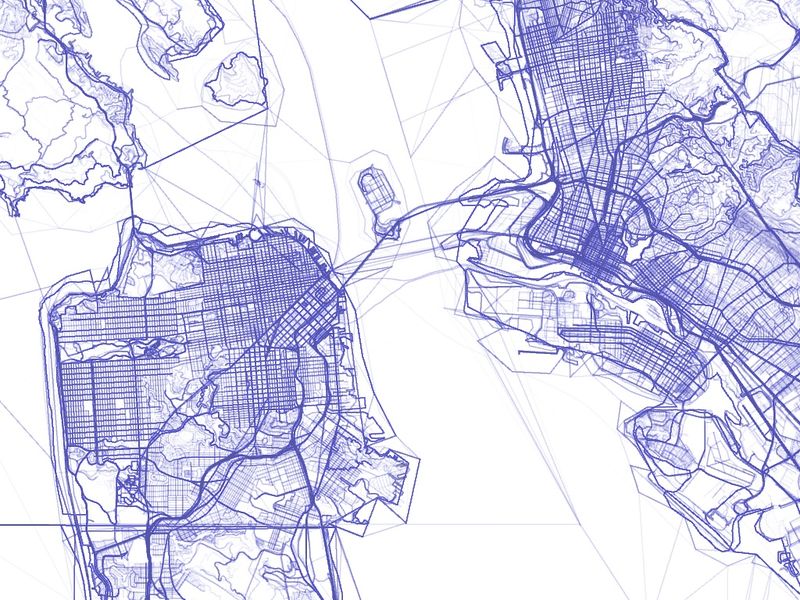
OpenStreetMap: Every Line Ever (San Francisco). More info, Slippy map, approximate location on osm.org. The OSM data from late 2012 was used.
This is a Featured image, which means that it has been identified as one of the best examples of OpenStreetMap mapping, or that it provides a useful illustration of the OpenStreetMap project. If you know another image of similar quality, you can nominate it on Featured image proposals.
Front-page image for week 47 of 2013 (18–24 Nov.).
- Image descriptions
- Deutsch : Alle jemals existenten Linien in San Francisco! Im künstlerischen Experiment „OpenStreetMap: Every Line Ever, Every Point Ever“ wird jede Version jedes je in den OSM-Daten existenten Punkt- oder Linien-Objekts gezeichnet. Lies mehr Informationen (engl.) und erkunde die Slippy Map von San Francisco oder London.
- English : Every Line Ever in San Francisco! “OpenStreetMap: Every Line Ever, Every Point Ever” is an artistic experiment in drawing every version of every point or line feature that ever existed in the OSM database. Read more info and explore the slippy map of San Francisco or London.
- español : ¡Todas las líneas existentes en San Francisco! Es un experimento artístico "OpenStreetMap: Every Line Ever, Every Point Ever" el cual consiste en dibujar cada punto o línea característica que haya existido en la base de datos de OSM. Lea para más información y explore un Slippy Map de San Francisco o Londres
- italiano : Ogni linea a San Francisco, da sempre! “OpenStreetMap: Every Line Ever, Every Point Ever” è un esperimento artistico che consiste nel disegnare tutte le versioni di ogni punto o linea che sia mai esistito nel database di OSM. Per maggiori informazioni leggi qui (in inglese) ed esplora la slippy map di San Francisco o Londra.
- Nederlands : Alle lijnen die ooit bestaan hebben in San Fransisco! In het kunstproject “OpenStreetMap: Every Line Ever, Every Point Ever” wordt iedere versie van iedere punt of lijn getekend die ooit in OSM heeft gestaan. Lees meer informatie, en bekijk de kaart van San Francisco of Londen.
- русский : «OpenStreetMap: Every Line Ever, Every Point Ever» — художественный эксперимент по отображению всех линий или точек, когда-либо существовавших в ОСМ. См. информацию о проекте, а также карты Сан-Франциско и Лондона.
- 中文(简体) : 在旧金山的每条线条! "开放街图:每条曾有的线条,每个曾有的节点"是绘制曾在开放街图资料库存在,所有节点的所有版本的美术实验。 了解详情以及探索旧金山或是-every-point/london.html 伦敦的滑动地图。
- 中文(繁體) : 在舊金山的每條線條!"開放街圖:每條曾有的線條,每個曾有的節點"是繪製曾在開放街圖資料庫存在,所有節點的所有版本的美術實驗。瞭解詳情以及探索舊金山或是倫敦的滑動地圖。
Licensing
![]()
![]()
![]()
This work is licensed under the Creative Commons Attribution-ShareAlike 2.0 License.
Attribution not specified as a parameter! THIS LICENSE ALWAYS REQUIRES ATTRIBUTION! Use {{CC-BY-SA-2.0|Attribution, typically name of author}} See Template:CC-BY-SA-2.0 for full description how this template should be used.
Note, there is
There is also
Attribution not specified as a parameter! THIS LICENSE ALWAYS REQUIRES ATTRIBUTION! Use {{CC-BY-SA-2.0|Attribution, typically name of author}} See Template:CC-BY-SA-2.0 for full description how this template should be used.
Note, there is
{{CC-BY-SA-2.0 OpenStreetMap}} for files based on old OSM map data, before the license change made on 2012-09-12.There is also
{{OSM Carto screenshot||old_license}} for files based on old OSM map data, before the license change made on 2012-09-12, created using OSM Carto map style.
(see [1] and uploader here)
- data is © OpenStreetMap contributors, licensed CC-BY-SA (not ODbL, because the data was accessed before OSM's license change in late 2012).
File history
Click on a date/time to view the file as it appeared at that time.
| Date/Time | Thumbnail | Dimensions | User | Comment | |
|---|---|---|---|---|---|
| current | 07:58, 11 November 2013 | | 1,024 × 768 (426 KB) | Alan (talk | contribs) | OpenStreetMap: Every Line Ever (San Francisco). http://graphspace.com/every-line-every-point/ |
You cannot overwrite this file.
File usage
The following 6 pages use this file: