File:Nowitna river.jpg
Jump to navigation
Jump to search


Size of this preview: 800 × 563 pixels. Other resolutions: 320 × 225 pixels | 640 × 451 pixels | 875 × 616 pixels.
Original file (875 × 616 pixels, file size: 127 KB, MIME type: image/jpeg)
This file and its description are from Wikimedia Commons.
| Description |
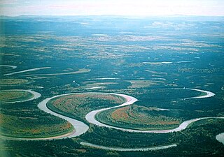
Deutsch: Unterlauf des Nowitna River, kurz vor der Mündung in den Yukon River, Alaska, vom Flugzeug aus gesehen, man erkennt den stark mäanderförmigen Verlauf
English: Meanders of Nowitna River, Alaska |
| Date | |
| Source |
Own work (Oliver Kurmis) English: Transferred from de.wikipedia.org [1]: 2004-11-26 23:28 . . Kurmis |
| Author | Oliver Kurmis |
| Permission (Reusing this file) |
Oliver Kurmis, the copyright holder of this work, hereby publishes it under the following license: This file is licensed under the Creative Commons Attribution-Share Alike 2.0 Germany license. Attribution: Oliver Kurmis
 |
| Other versions |
Derivative works of this file: |

![[1]](https://de.wikipedia.org/wiki/File:Nowitna_river.jpg)
| Camera location | | View this and other nearby images on: OpenStreetMap |
|---|
File history
Click on a date/time to view the file as it appeared at that time.
| Date/Time | Thumbnail | Dimensions | User | Comment | |
|---|---|---|---|---|---|
| current | 08:33, 25 December 2013 | | 875 × 616 (127 KB) | wikimediacommons>Beyond My Ken | Crop out blur on left side and slight sdjustments |
File usage
The following 19 pages use this file: