File:OpenMapSurfer HillshadeLayer.png
Jump to navigation
Jump to search


Size of this preview: 773 × 600 pixels. Other resolutions: 310 × 240 pixels | 619 × 480 pixels | 905 × 702 pixels.
Original file (905 × 702 pixels, file size: 1.14 MB, MIME type: image/png)
Description
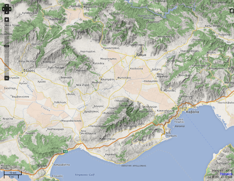
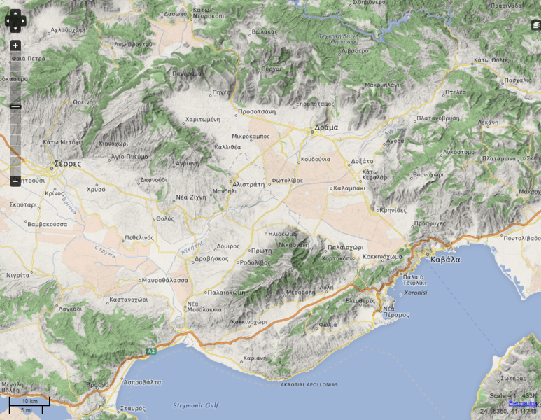
Screenshot of a map rendering with hillshading by OpenMapSurfer - shown here: openmapsurfer "OSM Roads (new)" with "ASTER GDEM & SRTM Hillshade (experimental)". Same place on OSM.org (in Greece).
This is a Featured image, which means that it has been identified as one of the best examples of OpenStreetMap mapping, or that it provides a useful illustration of the OpenStreetMap project. If you know another image of similar quality, you can nominate it on Featured image proposals.
Front-page image for week 43 of 2013 (21–27 Oct.).
- Image descriptions
- Deutsch : Eine Kartendarstellung mit Schummerung von OpenMapSurfer – hier gezeigt: openmapsurfer "OSM Roads (new)" with "ASTER GDEM & SRTM Hillshade (experimental)" (Griechenland).
- English : A map rendering with hillshading by OpenMapSurfer – shown here: openmapsurfer "OSM Roads (new)" with "ASTER GDEM & SRTM Hillshade (experimental)" (Greece).
- español : Un mapa renderizado con sombreado de OpenMapSurfer – mostrado aquí: openmapsurfer "OSM Roads (new)" con "ASTER GDEM & SRTM Hillshade (experimental)" (Grecia).
- italiano : Una mappa con ombreggiatura del terreno creata da OpenMapSurfer – che mostra questa zona openmapsurfer "OSM Roads (new)" with "ASTER GDEM & SRTM Hillshade (experimental)" della Grecia.
- Nederlands : Een kaartrender met schaduwen door OpenMapSurfer – hier zien we openmapsurfer "OSM Roads (new)" met "ASTER GDEM & SRTM Hillshade (experimental)" (in Griekenland).
- русский : Новый стиль карты от OpenMapSurfer, детально показывающий рельеф местности. На примере — Греция.
- 中文(简体) : 具有等高线渲染的地图OpenMapSurfer,显示的是openmapsurfer "OSM Roads (new)" 和"ASTER GDEM & SRTM 等高线(实验性)"(希腊)。
- 中文(繁體) : 具有等高線渲染的地圖OpenMapSurfer,顯示的是openmapsurfer "OSM Roads (new)" 和 "ASTER GDEM & SRTM 等高線 (實驗性)"(希臘)。
Licensing
see: [1]: "Content is available under Creative Commons Attribution-ShareAlike 2.0 license."
![]()
![]()
![]()
This work is licensed under the Creative Commons Attribution-ShareAlike 2.0 License.
Attribution not specified as a parameter! THIS LICENSE ALWAYS REQUIRES ATTRIBUTION! Use {{CC-BY-SA-2.0|Attribution, typically name of author}} See Template:CC-BY-SA-2.0 for full description how this template should be used.
Note, there is
There is also
Attribution not specified as a parameter! THIS LICENSE ALWAYS REQUIRES ATTRIBUTION! Use {{CC-BY-SA-2.0|Attribution, typically name of author}} See Template:CC-BY-SA-2.0 for full description how this template should be used.
Note, there is
{{CC-BY-SA-2.0 OpenStreetMap}} for files based on old OSM map data, before the license change made on 2012-09-12.There is also
{{OSM Carto screenshot||old_license}} for files based on old OSM map data, before the license change made on 2012-09-12, created using OSM Carto map style.
OpenStreetMap data is available under the Open Database License.
File history
Click on a date/time to view the file as it appeared at that time.
| Date/Time | Thumbnail | Dimensions | User | Comment | |
|---|---|---|---|---|---|
| current | 06:46, 22 October 2013 | | 905 × 702 (1.14 MB) | Runge (talk | contribs) | |
| 09:02, 24 January 2012 |  | 905 × 702 (1,012 KB) | Runge (talk | contribs) |
You cannot overwrite this file.
File usage
The following 8 pages use this file: