File:Priozerka osm.jpeg
Original file (2,736 × 3,648 pixels, file size: 2.8 MB, MIME type: image/jpeg)
Summary
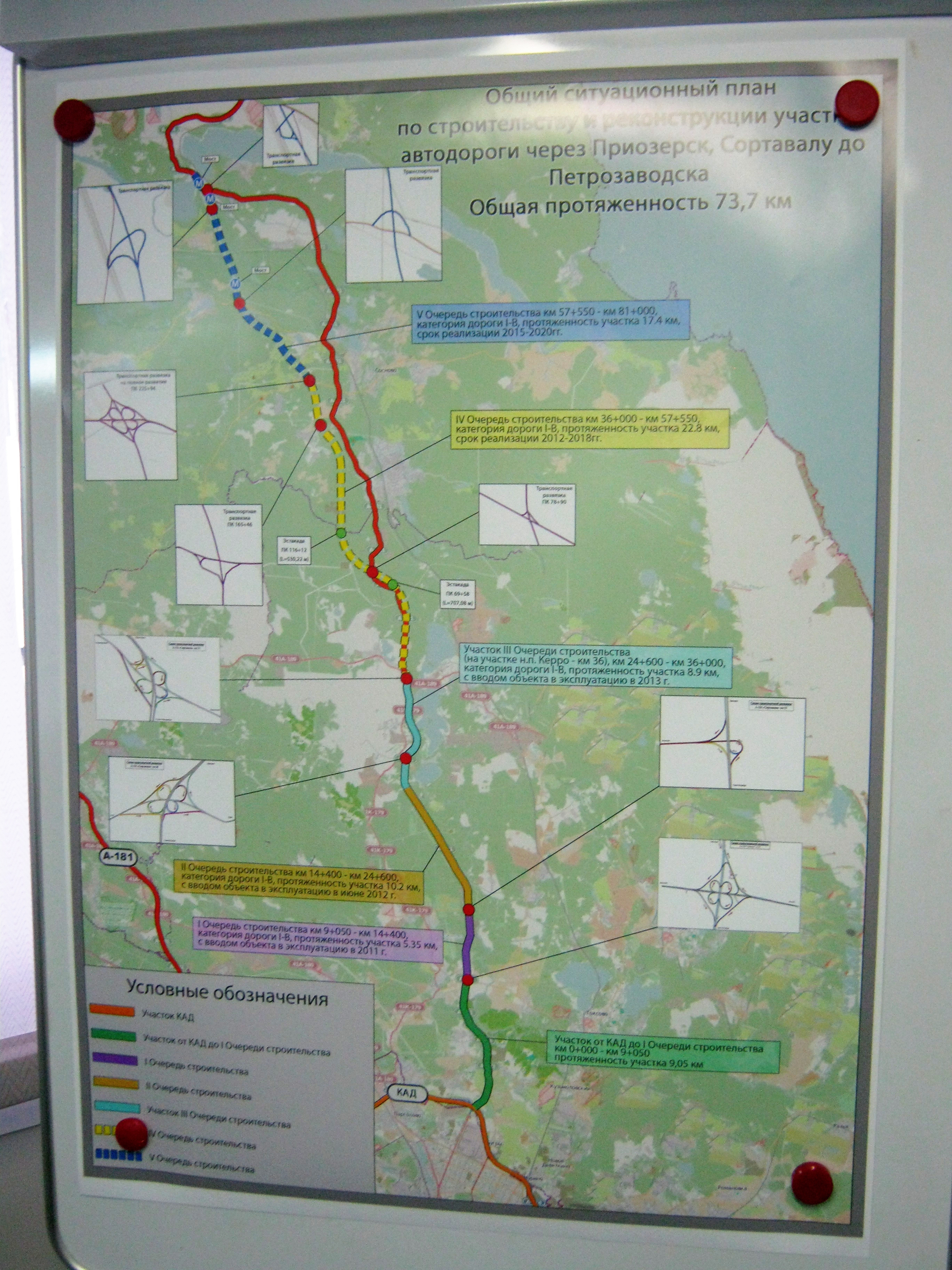
A poster at a Russian road construction company office, based on OSM: not only map layer is ours, but all junctions were also redrawn from OSM. User AlexTheTux traced most of them from local development plans and has updated some after this map was printed, making OpenStreetMap more correct than a poster in that office.
Map: Junctions are hand-drawn. Background is standard mapnik style (here).

Front-page image for week 11 of 2014 (10–16 Mar.).
- Image descriptions
- Deutsch : Eine Karte der russischen „Sortavala“-Straße in einem Büro des Straßenbauunternehmens. Das Poster zeigt auf einer OSM-Karte mit hervorgehobener Straße einige Kreuzungsdetails, die ebenfalls auf OSM-Daten basieren.
- English : A map of the “Sortavala” highway in Russia, on display at the road construction company offices. This poster has an OSM base map, and also inset details of road junctions based on the OpenStreetMap contributors data.
- español : Mapa de “Sortavala” una carretera en Rusia, en esta imagen se muestra las oficinas de la empresa constructora. El póster tiene como base un mapa de OSM, además se insertaron los cruces de las carreteras basados en nuestros datos.
- français : Une carte de l'autoroute “Sortavala” en Russie affichée dans les bureaux d'une entreprise de construction. Le fond de l'affiche est une carte OSM et les informations sur les jonctions sont basées sur les données des contributeurs d'OpenStreetMap.
- italiano : Una mappa dell'autostrada russa “Sortavala” affissa negli uffici dell'azienda di costruzioni stradali. Questo poster ha come base la mappa di OSM e sopra mostra i dettagli degli svincoli basati sui dati di OpenStreetMap.
- русский : Плакат в офисе дорожно-строительной компании «ВАД», сделанный из карты OSM: взят не только базовый слой, но и схемы всех развязок. Участник AlexTheTux срисовал их из местных генпланов, и обновлял карту после печати этого плаката, так что OSM сейчас актуальнее плаката «ВАД».
- 中文(繁體) : 在俄羅斯建設公司辦公室裡展示的“Sortavala”公路地圖。這張地圖基底是開放街圖,並且根據開放街圖用戶貢獻的資料,插入公路交流道等詳細資訊。
Licensing
- Photo by "nastoyatel" from spb-projects.ru (source).
- basemap © OpenStreetMap contributors
![]()
![]()
![]()
Attribution not specified as a parameter! THIS LICENSE ALWAYS REQUIRES ATTRIBUTION! Use {{CC-BY-SA-2.0|Attribution, typically name of author}} See Template:CC-BY-SA-2.0 for full description how this template should be used.
Note, there is
{{CC-BY-SA-2.0 OpenStreetMap}} for files based on old OSM map data, before the license change made on 2012-09-12.There is also
{{OSM Carto screenshot||old_license}} for files based on old OSM map data, before the license change made on 2012-09-12, created using OSM Carto map style.
The author agreed to share it on CC-BY-SA terms, original image will have its license changed in some time. confirmation
File history
Click on a date/time to view the file as it appeared at that time.
| Date/Time | Thumbnail | Dimensions | User | Comment | |
|---|---|---|---|---|---|
| current | 12:15, 12 March 2014 | | 2,736 × 3,648 (2.8 MB) | Aseerel4c26 (talk | contribs) | improved colours |
| 14:16, 2 December 2013 | 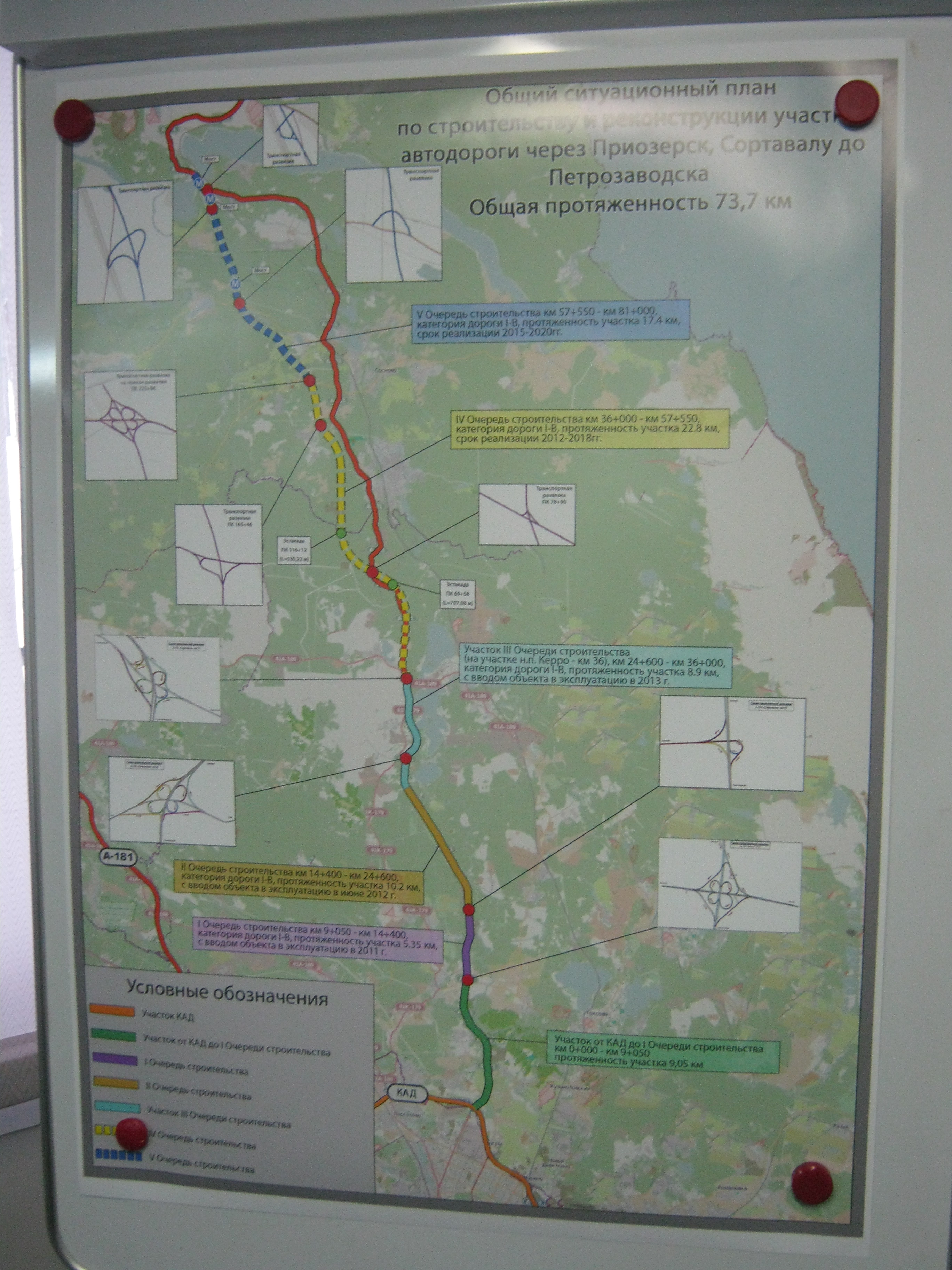 | 2,736 × 3,648 (2.35 MB) | Zverik (talk | contribs) | Photo by "nastoyatel" from spb-projects.ru. License unknown, a request was sent to make it CC-BY-SA. |
You cannot overwrite this file.
File usage
The following 10 pages use this file:
- Featured images/Jan-Mar 2014
- List of featured images/2014
- Using OpenStreetMap/Map examples
- Talk:Featured images/Jul-Sep 2014
- Talk:Wiki/Archive 3
- Template:Iotw image/2014-11
- DE:Featured images/Jan-Mar 2014
- DE:OpenStreetMap benutzen/Beispielkarten
- FR:Featured images/Jan-Mar 2014
- IT:Featured images/Jan-Mar 2014