Key:building:min_level
 |
| Description |
|---|
| For describing number of values "filling" space between ground level and bottom level of building or part of building. |
| Group: buildings |
| Used on these elements |
| Requires |
|
| Useful combination |
|
| See also |
| Status: de facto |
| Tools for this tag |
For marking the number of levels of a building (building=*) or part of a building (building:part=*) above ground level, we use tag building:levels=*.
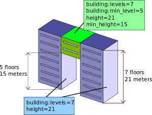
If a building part does not start at the ground level, building:levels=* should include the number of skipped levels below the building part (i.e the number of levels that would exist if the space between the ground and the bottom of the building part were filled with levels of the typical height for this building). These skipped levels themselves should be tagged as building:min_level=*.
It is therefore imperative that building:levels=* is always strictly greater than building:min_level=*. So this tag should be used only when building:levels=* is greater than 1.

Values
The value of this key is a natural number greater than zero (1, 2, 3, ...).
The default value is 0 when the building or building part starts from ground level. If the value is 0, then do not add this tag.
Photos
Real life examples with building:min_level=1
-
A residential building with a tunnel section. See on OSM
-
Commercial building across a big road (skipping ground floor). See on OSM

