Lexington KY/Building Outlines Import
Work In Progress
We will create a detailed discussion on the OSM mailing lists (imports-us@ and imports@) in in February 2016. The lists seem to agree on our direction and process, following in the footsteps of Louisville's work.
This process will be in accordance with OSM's Import Guidelines.
Involvement
| Everything that mappers need to know to get involved should be found in our live Contributor Guide. |
We are working to gather every local mapper we can who has experience with OpenStreetMap. We have made contact with several of the top contributors in the area. Local contributors committed to the import include:
Our initial push on this import will begin with Code for America's 2016 national Code Across hackathon on March 5-6 at MakeTime. It will be the focus of Lexington's Code Across event. In addition to leaning on the expertise of more seasoned contributors, we will be working closely with those newer to OSM to both assure quality and to hopefully empower them to become regular contributors.
You can begin mapping an area with our project on OSM Tasking Manager: http://tasks.openstreetmap.us/project/28 (unpublished).
About the data
Via data.lexington.gov Lexington-Fayette Urban County Government (LFUCG) provides us with a public domain shapefile of impervious surfaces derived from 2007 orthophotography. Those features classified as "building" will be used as the building footprints for our import. LFUCG similarly provides us with a shapefile of addresses updated quarterly (Current as of 1/25/2016).
License
The data provided by LFUCG are licensed under the ODC Public Domain Dedication and License (PDDL). This is summarized by the Open Data Commons as follows:
You are free:
To Share: To copy, distribute and use the database.
To Create: To produce works from the database.
To Adapt: To modify, transform and build the database.
Data to Import
Building Outlines
- Source Data: http://data.lexingtonky.gov/dataset/impervious-2007
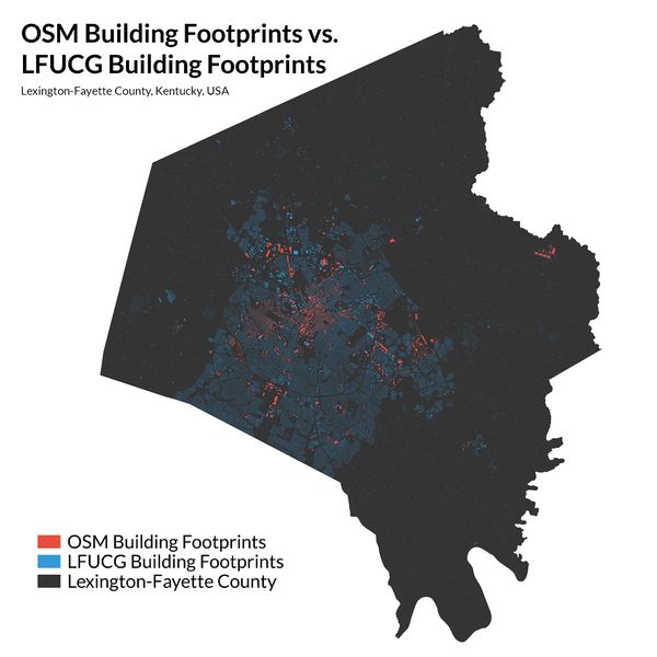
140,948 official buildings vs 7,233 existing OSM user contributions (~5%).
Street Addresses
- Source Data: http://data.lexingtonky.gov/dataset/address-points
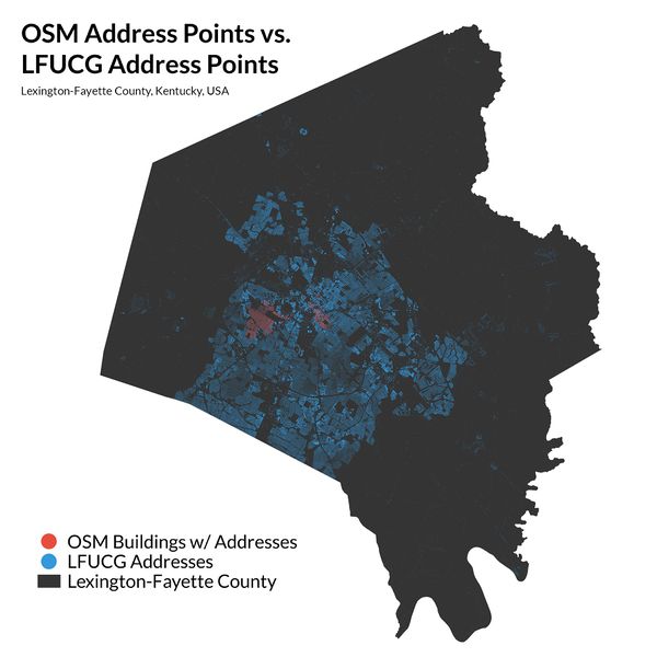
175,689 official addresses vs 3,807 existing OSM user contributions of addressed buildings (~2%).
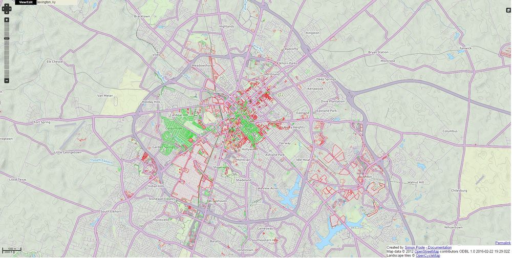
Bright green = address mapped. Bright red = no address mapped. Everything else has no address in OSM. See http://qa.poole.ch/ for details.
See progress for Lexington: http://qa.poole.ch/?zoom=13&lat=38.03828&lon=-84.49008&layers=FTTF0B
Buildings Plus Addresses
Our solution might be to load buildings with address data associated with it already, where possible.
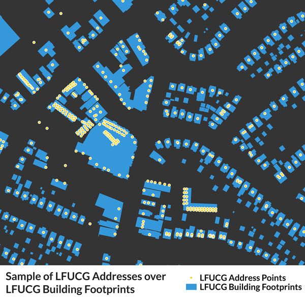
Sample of LFUCG address data overlayed on LFUCG building data. For single-address buildings, addresses are centered over the center of the building footprint, if there is a building. Then they are centered on the parcel (parcels not shown in this image). In the case of condos, they are stacked and slightly offset.
Data Analysis
Qualitative analysis manually comparing existing OSM data to city data in neighborhoods (Downtown, Chevy Chase, Masterson Station, etc.) well known by contributers shows that the address and building data is of high quality. We will still be examining things closely during the import but we are confident that this will be a useful addition to the OSM community.
Tagging
- building = yes
If building only contains one address, the following will be added to the area.
- addr:housenumber = STADD
- addr:street = STDIR (expanded: N->North) + STNAME + STTYPE (expanded: ST->Street)
- addr:state = KY
- addr:city = Lexington
- addr:postcode = 5 digit post code
In the case with multiple addresses in different locations within the same building footprint, these tags will go on separate nodes with unit numbers:
- addr:unit = for individual address points, all placed withing building footprints. Eg, 1, 201, C.
Reconciliation with existing buildings in OSM
There are not a lot of buildings already in OSM for Lexington, KY. As of February 2016 there are just over 7,000, which is about 5% of the total. Where there is overlap, we will preserve the OSM edits, unless the city data is obviously better on a case by case basis.
Conflation with existing addresses in OSM
175,689 official address point data vs almost no existing data in OSM. We will manually compare any overlap and choose the best address locations based on our conflation with the building data and local knowledge.
Participants
- Ryan Cooper: Project lead. Frequent OSM contributor, GISer/Cartographer, organizer of maptimeLEX
- Chase Southard: Project lead. Organizer of OpenLexington.
- Michael Schnuerle: Consultant. Co-captain of Louisville's Code for America Brigade and project lead for the Louisville import.
Process
User accounts
In accordance with Import Guidelines, each uploader will use a separate user account specifically for this import. The user name will follow the pattern: <regularusername>_lexingtonimport
Task Manager
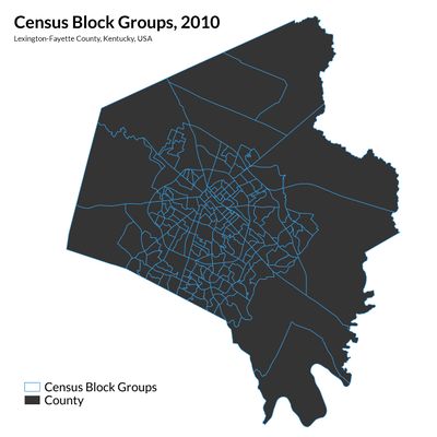
We will use the OSM Task Manager to divide up the work. The data for the import will be chunked by 2010 Census Block Groups for Fayette County.
Workflow
See the Contributor Guide for all the details!
Resources
Learning JOSM
JOSM is a bit different than working with the browser-based iD Editor. Some of these links might be useful when making the transition:
- Tutorial: Your first steps with JOSM - the Java OpenStreetMap editor
- Tutorial: Become a power mapper!
Info from previous imports
- Video: How to set up JOSM to integrate with task manager
- Video: creating an account for import
- How to review and upload data from .osm files using Potlatch 2
Getting the import started
- OSM NYC Building and Address Import (playlist of several ~2 minute video screencasts) (one note: we will have a different OSM tasking manager URL than in the NYC case. Otherwise the same steps should work fine.)
QA tools
Source Code
This is based on work from the Louisville and DC and NYC and NOLA building imports, thanks to the folks who made that possible.
