New Forest workshop 2006
This a past event which took place way back in 2006 in the New Forest (UK) 23rd-24th September 2006
OpenStreetMap Project and the New Forest Workshop
On the 23rd-24th September 2006, the New Forest becomes the centre of a global mapping revolution. Contributors to the OpenStreetMap (OSM) project are going to meet with the aim of mapping as many of its footpaths, cycle tracks and roads as possible.
The OSM project was started to enable people to use maps in creative, productive or unexpected ways. The use of traditional maps is hampered by legal and technical restrictions that severely curtail their use. The aim of the OSM project is to create free geographic data, like street maps, that can be used by anyone, anywhere.
OSM contributors will walk, cycle and drive the New Forest with GPS (Global Positioning System) units recording the routes of as many of the tracks, paths and roads as possible. The tracks recorded will be put online in the OpenStreetMap.org database where anyone in the world with access to the internet can browse, name, edit and use the data in any way they want.
Collaborative mapping is an emerging and rapidly growing activity that has developed alongside other activities like geo-caching, that is being driven in part by technology (cheap GPS equipment and online collaboration tools, like OpenStreetMap.org). What makes projects like this one stand out is their ethos on knowledge production and ownership. Under open-source models the rights of authorship are de-centred and the ownership of knowledge is seen as a common resource that can be distributed and re-used without restriction or license. Opening up map making in this way has real potential to empower people to create their own knowledge and encourages re-use of cartographic resources in novel and creative ways.
The map data produced over the weekend will contribute to OpenStreetMap.org, one of the leading projects in the open-source mapping field. Currently, OSM has mapped 15,000 miles of roads in the UK, including all the motorways, along with a significant number of footpaths in Hampshire.
Similar workshops have been held on the Isle of Wight, Bath & Brighton. We hope that an intensive effort to build a map of the whole of the Forest in a weekend will inspire others and help to build momentum across the country.
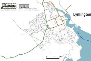
Sample maps
More Information
For more information on OSM see the frequently asked questions page, or follow the links to the left of this article.
