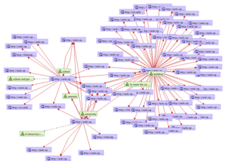
OSM Semantic Network

The OpenStreetMap Semantic Network is a Semantic Web resource extracted from the OSM Wiki website, encoded as a SKOS vocabulary. It contains a machine-readable representation of OSM tags, and several semantic relations between them. The network is Linked Open Data. This semantic network is extracted by an open source crawler developed in Java/Groovy, the OSM Wiki Crawler. The OSM tags are mapped on corresponding concepts in WordNet and LinkedGeoData.
Dataset
| The SPARQL endpoint at http://spatial.ucd.ie/lod/sparql will be offline indefinitely. Therefore, users are encouraged to download the RDF dump offline and use it directly. Apologies for the inconvenience. |
The dataset is available in the following ways:
- Github repository
- RDF file: osm_semantic_network.skos.rdf
- Mappings with WordNet and DBPedia: mappings.rdf
- SPARQL end point: http://spatial.ucd.ie/lod/sparql (Houston, App crashed !)
- RDF/NT dumps (archive): http://github.com/ucd-spatial/OsmSemanticNetwork
- Entry at the CKAN Data Hub: http://datahub.io/dataset/osm-semantic-network
RDF/SKOS content
The OSM Semantic Network is an RDF graph extracted from this wiki website. It is a SKOS vocabulary.
Namespace: http://spatial.ucd.ie/lod/osn
Short namespace: osn
Concepts
- osn/term/k:<key> OSM Key (e.g. http://spatial.ucd.ie/lod/osn/term/k:amenity).
- osn/term/k:<key>/v:<value> OSM Tag (e.g. http://spatial.ucd.ie/lod/osn/term/k:waterway/v:canal).
- osn/proposed_term/<tag> OSM Proposed Tag. (e.g. http://spatial.ucd.ie/lod/osn/proposed_term/Lock)
Semantic relations (RDF properties)
The following semantic relations (RDF properties) are utilised in the network:
- osn:property/altLanguageSource
- osn:property/appliesTo
- osn:property/combinedWith
- osn:property/image: image representing the term;
- osn:property/implies
- osn:property/key
- osn:property/keyLabel
- osn:property/linkedTo: general hyperlink, can be used for link analysis;
- osn:property/redirect: redirect, equivalent to owl:sameAs
- osn:property/tagInfo
- osn:property/valueLabel
- osn:property/wikipediaLink: link to a Wikipedia page (and therefore to a DBpedia resource).
Semantic similarity of OSM tags
In OpenStreetMap, map features are described with tags, such as amenity=university, and highway=primary. These tags correspond to geographic concepts, represented in our OSM Semantic Network. Using the OSM Semantic Network, it is possible to compute the semantic similarity of the tags. For example, a university is conceptually more similar to a school than to a river. A semantic similarity measure aims at quantifying this fact with a real number, typically between 0 and 1.
The folder http://spatial.ucd.ie/osn/similarities contains pre-computed similarity scores between OSM tags. These scores were computed using co-citation measures, based on link patterns between the network nodes. Please note that different similarity measures can be more or less appropriate depending on the particular application context. Based on our empirical evaluation, PRank measures obtain the best results in an abstract setting.
Examples
Example of SPARQL queries on the OSM Semantic Network (currently offline):
- Term Tag:amenity=university: select distinct * where { <http://spatial.ucd.ie/lod/osn/term/k:amenity/v:university> ?p ?o }
- All terms related to Key:school: select distinct * where { <http://spatial.ucd.ie/lod/osn/term/k:amenity/v:school> skos:related ?o }
Reference
If you use the OSM Semantic Network in your research, please reference this paper:
   Ballatore, A., Bertolotto, M., & Wilson, D. C. (2013).
   Geographic knowledge extraction and semantic similarity in OpenStreetMap.
   Knowledge and Information Systems, 37(1), 61-81.
Author and contact
Project author and maintainer: Andrea Ballatore
If you have any issue/comment/suggestion, drop an email at andrea.ballatore [at] gmail.com.
Related Projects
- OSMonto
- LinkedGeoData
- JOSM/Plugins/OSMantic#OSMantic
- TagFinder (tagfinder_thesaurus.rdf, Github)
- Data Items
See also
- |Wikidata =, in Template:Description
- Property:P1282, "OpenStreetMap tag or key", in Wikidata (inverse of the above)