OpenHistoricalMap/Projects/Germany/Messtischblätter
Jump to navigation
Jump to search
Messtischblatt or Meßtischblatt is a term describing Topographical Maps in Germany in a Scale of 1:25.000. It describes:
- Preußische Landesaufnahme since 1876
- Luftbildplanwerk since 1928 – 1944 (respectively 1933)
These historical Messtischblätter are succeeded by todays TK 25. This Project Page aims to collect possible tagging guidelines for symbols and inscriptions on these types of historical maps. Please feel free to add resolutions of map symbols and abbreviations or propose tagging.
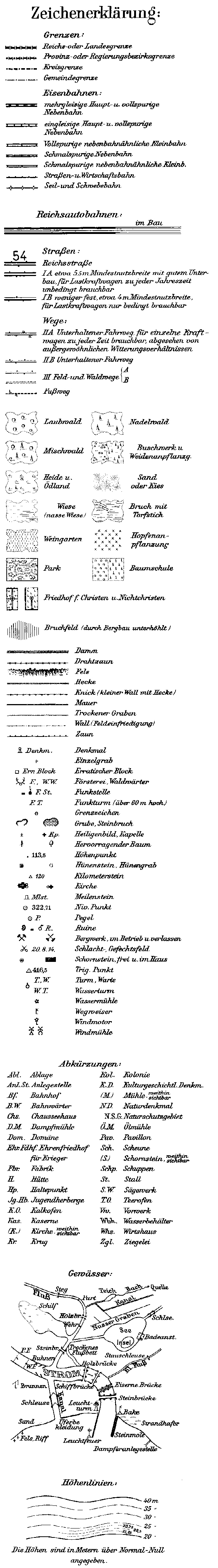
List of Map Legends
Since 1876
- Landkartenarchiv
- Erläuterungsheft mit Zeichenerklaerung zur Preußsichen Landesaufnahme in Niedersachsen ab 1877 [PDF][1]
- Deutsche Fotothek
Since 1928 or 1933
_z_1933.jpg)
Abbreviations and inscriptions
Since 1928
| Abbreviation | Resolution | Proposed Tagging |
|---|---|---|
| Abl. | Ablage |
|
| Anl. St. | Anlegestelle | ?
|
| Bf. | Bahnhof |
|
| B.W. | Bahnwärter(haus) |
|
| Chem. Fbr. | Chemische Fabrik |
|
| Chs. | Chausseehaus |
|
| D.M. | Dampfmühle |
|
| D.S.M | ? | |
| Dom. | Domäne(Landgut) |
|
| Ehr. Fdhf. | Ehrenfriedhof für Krieger |
|
| Eiswerk(e) | Eiswerk |
|
| Fbr. | Fabrik |
|
| H. | Hütte |
|
| Hp. | Haltepunkt |
|
| Jg. Hb. | Jugendherberge |
|
| Krankenhs. | Krankenhaus | |
| K. O. | Kalkofen |
|
| Kas. | Kaserne |
|
| (K.) | Kirche (weithin sichtar) |
|
| Khf. | Kirchof | |
| Kr. | Krug (ländliche Gaststätte) |
|
| Kol. | Kolonie (ländliche Siedlung) |
|
| K. D. | Kulturgeschichtliches Denkmal |
|
| Laboratorium | Labor |
|
| (M.) | Mühle (weithin sichtbar) |
|
| N.D. | Nationaldenkmal |
|
| N.S.G. | Naturschutzgebiet | |
| Ö.M. | Olmühle | See also: DE:Tag:craft=oil_mill
|
| Pav. | Pavillon | See also: DE:Tag:shelter_type=pavilion
|
| Sch. | Scheune | See also: DE:Tag:building=barn
|
| Schiess. St. | Schießstand |
|
| (S.) | Schornstein (weithin sichbar) | See also: DE:Tag:man_made=chimney
|
| Schp. | Schuppen | See also: DE:Tag:building=shed
|
| St. | Stall | See also: DE:Tag:building=livestock
|
| S.W. | Sägewerk | See also: DE:Tag:craft=sawmill
|
| T.O. | Teerofen |
|
| Vw. | Vorwerk |
|
| Wbh. | Wasserbehälter |
|
| Whs. | Wirtshaus |
|
| Zgl. | Zieglei |
|
Highways
![]()
For highways and roads of which traces are still visible on aerial imagery you could use tagging like trace_condition=barely_visible
Since 1876
| Symbol | Resolution | Proposed tagging |
|---|---|---|
| Kunststraßen | ||
| Chaussee
(Kunstraße 1. Klasse) |
| |
| Gebauter Weg
(Kunsstraße 2. Klasse) |
| |
| Wege ohne Kunstbau | ||
| Gebesserter Weg |
| |
| Gewöhnlicher Verbindungsweg |
| |
| Whirtschaftsweg
(Feldweg, Waldeweg) |
| |
| Fussweg |
| |
Since 1928
| Symbol | Resolution | Proposed tagging |
|---|---|---|
_z_1933_(Reichstra%C3%9Fe_-_Highway%3DPrimary).jpg)
|
Reichstraße |
|
| IA[2] |
|
Vegetation and landuse
Since 1928
| Symbol | Resolution | Tagging |
|---|---|---|
_z_1933_(Laubwald).jpg)
|
Laubwald |
|
| Nadelwald | ||
| Mischwald | ||
| Heide | ||
| Wiese (nasse Wiese) | ||
| Weingarten |
Resources for Messtischblätter
See also: OpenHistoricalMap/Resources/Germany
Since 1876
- Brandenburg (WMS)
- Mecklenburg-Vorpommern (WMS)
- Schleswig-Holstein (WMS)
- Sachsen (WMS)
- Thüringen (Download)
- Hessen (WMTS, TMS)
Since 1928
- Germany (TMS)
- Nordhein-Westfalen (WMS)
Further reading
- Erläuterungsheft mit Zeichenerklaerung zur Preußsichen Landesaufnahme in Niedersachsen ab 1877 [PDF]
Notes
- ↑ Last page
- ↑ Link zum Bild