Proposal:Destination symbols for recommended/restricted/hazardous routes routes
| Destination restrictions/recommendations/hazards | |
|---|---|
| Proposal status: | Draft (under way) |
| Proposed by: | Penegal |
| Applies to: | |
| Definition: | Mean to tag the symbols of destination signs which warn in advance about remote access restrictions, hazards or recommendations |
| Rendered as: | 
|
| Draft started: | 2022-07-15 |
Proposal

On some destination signs, there are symbols expliciting that a specific destination is or is not reachable following a specific route, or that this route is exposed to some hazards. For instance, the destination signs on the right picture tells that the right road is a route to Vichy, Saint-Yorre and the local stadium, but also explicits that HGV above 7.5t are able to use this route to reach Vichy.
As these symbols are often displayed per destination, this proposal is about a way to model these restriction/recommendation/hazard symbols as destination:* values. Typical users of the proposed keys/values would be route planners which simulate the appearance of destination signs (with the help of destination:colour, destination:symbol, destination:ref…) to help drivers to find their route more quickly.
Rationale

Access restrictions and hazards are tagged on highways with specific tags on the specific highway segments subject to restrictions. For instance, a road impassable by HGV would be tagged hgv=no, and a road exposed to animal crossing would be tagged with hazard=animal_crossing. This kind of tags explicitly links the access restrictions and hazards to a specific highway, and is typically enough for data consumers; for instance, a route planner encountering hgv=no would try to check if the planned route is to be used by a HGV and, if so, could prepare a new route avoiding this highway.
In order to provide advance warning of such restrictions and hazards, the destination signs may show symbols warning the drivers of restrictions/hazards they could encounter if they follow the pointed highway to reach a specific destination. Say that a driver wants to go to Ballaison and encounters the sign on the right picture. This driver would then have to choose on which way to turn according to the characteristics of his/her vehicle:
- if s/he drives a HGV over 7.5t, s/he should choose to turn left;
- if s/he drives a HGV under 7.5t or another kind of vehicle, s/he should choose to turn left.
This is not the restriction/hazard you are looking for

It is important to note that such symbols are not restriction/hazard signs by themselves: they do not replace restriction/hazard signs placed along a highway at the segments subject to restrictions, and they don't enforce a restriction. They are mere advanced warning signs, designed to help a driver to choose his/her route according to existing restrictions or hazards before encountering them.
This may be counterintuitive, because such signs typically look like standard restriction/hazard signs, but the right example should explain why such signs are not, for instance, restrictions by themselves. According to this schema, Ballaison is reachable through two main routes:
- if you drive a HGV over 7.5t, you should choose to turn left and follow the D 1, leading you to then follow the D 2, and again the D 1;
- if you drive a HGV under 7.5t or another kind of vehicle, you should choose to turn left and follow the D 225, then the N 1 all the way to Ballaison.
Whatever the way you decide to follow and the kind of vehicle you drive, there are other routes to Ballaison than the signed ones. The destination signs are designed to allow drivers to simply find the shortest/quickest routes for a simple reason: it is what the typical driver would look for.
That being said, according to your vehicle, the time you have to reach Ballaison and whether you care about high fuel prices or not, you may simply express your imagination and enjoy the landscapes by choosing another route which is neither the quickest nor the shortest route, and still reach Ballaison.
Differing owners
Furthermore, on the right picture and schema, you may notice the blue symbol, which is in no way a restriction: it is a bare recommendation, advising drivers that, if their vehicle match some characteristics (here, if they drive a HGV over 7.5t), they should choose to turn left. For instance, even if you drive a HGV over 7.5t, you could turn right, then use the C 2, and then join the N 1 by turning right, then left, and then drive to Ballaison, without driving in the restricted highway.
This situation with the example highway network may also happen for a rather trivial reason: the C 2 owner may differ from the operator installing the destination sign (differing admin levels, for instance), and thus the destination sign must be designed to ignore, in this case, the C 2 highway. In France, for instance, the Cx roads are owned by cities and villages, and the Dx roads are owned by higher authorities; as a consequence, destination signs on Cx roads legally cannot give a direction if, to reach this destination, you are required to drive along a Cx road. In this schema, the D 255 destination sign legally cannot tell all the vehicles, including HGVs over 7.5t, to turn right, and then assume that HGVs over 7.5t will use the C 2: it must be designed to ignore the C 2 road, which is owned by a different admin level, and thus must tell to HGVs over 7.5t to turn left, even if they technically could reach Ballaison by turning right.
Miscellaneous
There may be other situations:
-
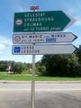
 Discrepancies between a restriction sign and the alternative recommended route: here, the recommendation sign for the right route is for all HGV, even those below 12t which may choose to turn left
 -
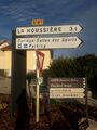 Recommendation symbols used simply to indicate that HGV and bus may find a parking space along a route
 -
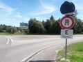 Forbidding of some vehicles vehicles (here, hazardous material vehicles of category E are prohibited to enter the tunnel 3km away)…
 -
 … with additional restrictions displayed on destination signs (here, an advance warning related to limitation of vehicle height at 4.3m is given for the same tunnel)
 -
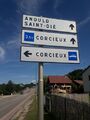 Recommendation signs without corresponding restriction: here, light vehicles are advised to turn left to reach Corcieux, and vehicles above 3.5t are advised to go ahead to reach the same town. The left road is slightly less broad, which may cause difficult crossings with heavy vehicles; that being said, there is no legal restriction, crossings are possible at decreased speed, and vehicles above 3.5t may perfectly choose to turn left to reach Corcieux
 -
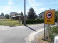 Some destination signs don't display a warning for immediate access restrictions, possibly because giving an advance warning for an immediate restriction is useless (here, HGV over 19t are forbidden to use this way)…
 -
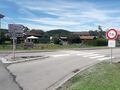 … but some other signs still display an advance warning, even if the restriction is immediate.


In the end, such signs should be treated by mappers and data consumers as mere symbols: even if a by-passer would view them as restriction/hazard advance warning or detour route recommendations, they may be used for other meanings and data users must not treat them for anything else than destination sign displays.
Tagging
Examples
https://www.mapillary.com/app/?lat=58.5929006&lng=16.156303&z=17&pKey=287843636156014&focus=photo Height limitation at 3.6m ahead (Sweden, Riiga)
https://commons.wikimedia.org/wiki/File:Svincolo_Spinea_nell%27A4.JPG No HGV over 7.5t (Italy)
https://commons.wikimedia.org/wiki/File:Knuten_skilt.JPG Not over 3.5m high (Norway)
https://www.legislation.gov.uk/uksi/2016/362/made Voir partie Schedule 12 pour la liste des possibilités au Royaume-Uni (exemples ici: https://assets.publishing.service.gov.uk/government/uploads/system/uploads/attachment_data/file/519129/know-your-traffic-signs.pdf et là https://commons.wikimedia.org/wiki/Category:Traffic_Signs_Manual_(UK)_(Volumes) )
https://commons.m.wikimedia.org/wiki/File:View_from_Emerald_Pkwy_US-33_overpass_(Dublin,_Ohio)_-_light_rush_hour_traffic_during_COVID-19_pandemic.jpg (Hazmat allowed to exit, US (Ohio))
_-_light_rush_hour_traffic_during_COVID-19_pandemic.jpg)
Rendering
Features/Pages affected
External discussions
Comments
Please comment on the discussion page.