Proposal:Multiple landuse V2
| Multiple landuse V2 | |
|---|---|
| Proposal status: | Draft (under way) |
| Proposed by: | Cartographer10 |
| Tagging: | landuse:additional=*
|
| Applies to: | |
| Definition: | A way to map multiple landuse on a single area |
| Statistics: |
|
| Draft started: | 2022-10-15 |
Proposal
This proposals proposes a namespaced addition to landuse namely:
landuse:additional=*: A tag to indicate one or multiple additional landuse in addition to the most dominant landuse tagged withlanduse=*. Multiple additional landuse values can be added with a ; separated list in an unordered/unranked order.
Rationale

Especially cities and villages have a lot of multifunctional landuse like a mix between landuse=residential, landuse=retail and landuse=commercial. For example, in a city center, the main landuse of a shopping area might be landuse=retail. It is quite common however that apartments are present above the shops. The current landuse tagging scheme cannot deal with the dual (or more) use. Currently, this is solved in 2 ways:
- The mapper chooses the most dominant landuse.
- Multiple landuse are being drawn on top of each other like can be seen on the image on the right. It might look fine on the map but this makes the data messy.
These practices have several downsides which this proposals seeks to revolve:
- Difficult to maintain: When a change is required, multiple overlapping polygons have to be edited. This can result in inconsistent data and mistakes when some polygons are missed (e.g. because they are outside of view).
- Messy for data users:' Before data users can use the data, they first have to check for the presence of overlapping polygons and correct this. This is additional work and can result in mistakes. In zonal plans (and geo data in general) overlapping polygons of the same type is also uncommon practice. If an overlap occurs (e.g. between residential and retail), a separate category is introduced like city centre or mixed landuse.
- Resulting in difficult choices for mappers: Restricting the landuse tag to only one entry per polygon also makes it harder for mappers to choose which landuse they want in case they don't want to use overlapping polygons. This proposal fixes that by giving mappers the option to add multiple landuses.
For now, this proposal is made for the landuse key. In theory this dual use can occur at other keys to like natural=* and the same namespacing of :additional can be used. This dual use problem occurs a lot at the landuse key so that is why this proposal focusses on that. If it is a success, it can be used for more tags.
Choice for tag
Several tags have been thought of:
landuse_1=*and so on has been used a few times according to tagInfo. This would introduce new top level keys where with namespacing, you built upon the existing landuse key. Also,landuse_1=*would mean it is the first landuse while this needs to belanduse=*to not break rendering and existing use. The 1 is misleading here. Additionally, this means that in potential, multiple tags could be created on the same area. This can also be confusing for data users in case multiple landuses are tagged. Namespacing is a much clearer solution here and looks nicer.- It was thought of to use
residential=apartmentsas addition tolanduse=retail. However,residential=*is a subtag forlanduse=residential, further specifying the residential landuse. Also, this means tags likeretail=*have to be created. Residential and retail are just examples. Theorerically, any landuse can overlap requiring multiple of these sub tags. - It was suggested to add this additonal information to the buildings. Then it is however no landuse mapping anymore so this is no option.
Semi-colon vs seperate tags
In the first (rejected) version of this proposal [[1]], separate tags for the additional values were used. While this seemed convenient at the time, semi-colon separated lists are preferred in this proposal for several reasons:
- Support by data users: While of course we need to keep data users in mind its up to them this case to support semi-colon value lists. It is a very convenient and easy way of storing multiple values for mappers. As example, most indoor mapping renderers support semi-colon separated
level=*values. - Separate tags indicate ranked order: The previously proposed values like :secondary and : tertiary indicate an order of importance in the landuse. This order is often not present and not verifiable.
Tagging
Draw an area and use landuse=* to indicate the most dominant landuse. The most dominant landuse is defined as: How most people use the land. Next, use landuse:additional=* to indicate one or more additional landuse. For multiple values, separate the values with a semi-colon (;). The order of the additional values does not matter.
Additionally, all sub tags that can be applied to landuse can be used as normal like name=* or residential=* without namespacing.
When not to use dual tagging
Dual landuse tagging should not be used if a value already implies the presence of another landuse value by definition. For example landuse=farmyard by definition already includes a house. There is no need to draw an area of landuse=farmyard and use dual tagging to add landuse=residential for the house.
Examples
Below, some example of multi landuse are illustrated.
| Example | Description | Proposed tags |
|---|---|---|
 Location on OpenStreetMap Location on OpenStreetMap
|
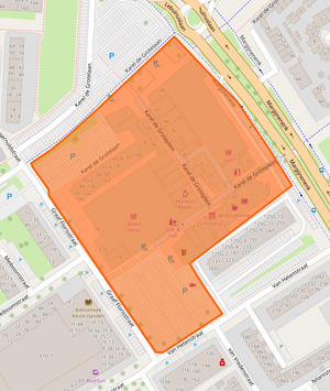
This area is a shopping are with shops at the ground floor. On top are some multi-story apartment buildings.
Because most people use the shopping area, this is the dominant landuse. |
landuse=retail
+
+ |
 Location on OpenStreetMap Location on OpenStreetMap
|
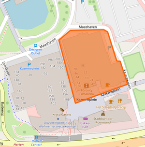
This area has a large cinema at the ground floor. On top, there is a multi-story apartment building.
Most people use the cinema rather then the apartments so the most dominant landuse is commercial. |
landuse=commercial
+
+ |
Rendering
Atleast on carto, these additional values do not need to be rendered. Like in the current situation, the value landuse=* is used for rendering. In the future, common combinations like retail and residential can be rendered differently.
Features/Pages affected
If this proposal gets accepted, the landuse=* page needs to be edited. Also, a new page for this tag will be created.
External discussions
The first version of this proposal has been discussed.
- Link to the first version of the proposal First version:
Comments
Please comment on the discussion page.