Proposal talk:Tailings pond
Opening Pedantry - "tailings pond"
To kick off discussion I'd like to start with some traditional pedantry. While "tailing" and "tailing pond" is occasionally used, the term most common in the mining industry (MSHA), standards and literature in the English language would be "tailings" for the mining debris itself and "tailings pond" for water-filled impoundments for the tailings. See quick worldwide Google trends on the terms ("tailings" is most common everywhere outside of India), and a Google Ngram search on use in literature (no use of "tailing pond" in literature). Minor issue, I know, but might as well get going with the most commonly accepted term for the feature. --Phidauex (talk) 05:32, 10 January 2021 (UTC)
Tailing pond with liquid vs total area
https://www.openstreetmap.org/#map=14/51.5137/16.2115 - and others, there should be separate tagging, allowing to mark separately
- Total area taken by industrial feature (including dams etc)
- Area of liquid waste inside
Mateusz Konieczny (talk) 15:17, 10 January 2021 (UTC)
outflow
"Since the purpose of tailing ponds is to contain hazardous substances, they do not have outflow" - note that some at least recycle water. For example Żelazny Most recycles water for repeated use for ore processing Mateusz Konieczny (talk) 15:37, 17 January 2021 (UTC)
- I added mention, feel free to revert/reword it Mateusz Konieczny (talk) 15:39, 17 January 2021 (UTC)
- Tailings ponds aren't supposed to have outflow, but many do, and that is a bad thing. The common thing in Colorado, and perhaps elsewhere, is to take old tailings ponds that had been outflowing into streams, rivers or other waterbodies, block the outflow completely, and then put a water treatment plant in that pulls overflow water from the tailings pond, treats it, and then discharges the treated water. Since a lot of tailings ponds are partially fed by streams or rainwater in addition to the ore processing, they will either outflow naturally or will require a water treatment facility. Example: (Robinson Tailings Pond at the Climax Mine. It spent many decades discharging toxic material into Ten Mile Creek, until the mine operators were compelled to install a water treatment facility. I'd suggest that the language be updated to include that tailings ponds may have unremediated outflows to streams or rivers, managed outflows such as associated water treatment plants, or no outflows at all. --Phidauex (talk) 17:25, 17 January 2021 (UTC)
Water areas
I would recommend mentioning that tailing ponds may include parts that are taggable as water and in some cases entire tailing pond may be considered also as a water area.
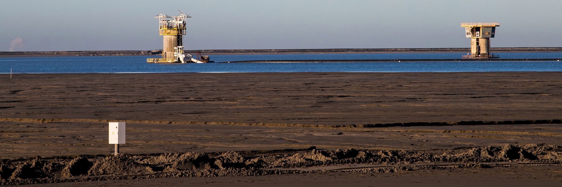
See for example https://www.openstreetmap.org/#map=14/51.5090/16.2196 with lake inside - see https://i.wpimg.pl/1920x640/d.wpimg.pl/1791840835-708705617/kghm.jpg (muddy water is pumped into massive tailing pond, it separates into sand/mud and water that forms lake inside and is recycled - I think that towers visible here are for water intake). Mateusz Konieczny (talk) 18:50, 17 January 2021 (UTC)
- Wouldn't that still be a tailings pond? As you describe it, it's a pond where (presumably-contaminated?) sand/mud is pumped and allowed to settle to the bottom and the water pumped off. I'm not sure we should encourage people to tag portions of a tailings pond that "look cleaner" than the rest of the pond on imagery, but I could be convinced. --ZeLonewolf (talk) 03:17, 18 January 2021 (UTC)
- It is part of tailing pond so it would be within
man_made=tailings_pondarea, but also a bit special part of tailing pond so there should be an available tagging for that. I would not tag just based on aerials (""look cleaner" than the rest of the pond on imagery"), but in this case I found multiple photos and description of this confirming that there is lake of polluted water inside (after slurry separates into rocky/sandy material and water). Not happy about tagging itnatural=waterbut there should be some way to tag that area Mateusz Konieczny (talk) 08:44, 18 January 2021 (UTC)
- It is part of tailing pond so it would be within
- Wouldn't this concept be covered by
man_made=spoil_heapfor the solid areas, andman_made=tailings_pondfor the liquid part? What am I missing here? Is there a third category? --ZeLonewolf (talk) 17:55, 18 January 2021 (UTC)
- Wouldn't this concept be covered by
- One of input pipes is visible in a photo taken from crown of dam with visible slurry. Note tower on horizon, such tower is visible in photo of "lake" of something that can be described as polluted water, after heavier fraction dropped to the bottom Mateusz Konieczny (talk) 08:47, 18 January 2021 (UTC)
- Also https://wiki.openstreetmap.org/wiki/File:G._Kachkanar,_Sverdlovskaya_oblast%27_Russia_-_panoramio.jpg seems to be possibly taggable as water area (not sure based on just photo) Mateusz Konieczny (talk) 19:03, 17 January 2021 (UTC)
- Looking over this discussion, I don't see a clear case for the conditions under which a mapper would decide that a portion of a tailings pond should be tagged as water. A lake of polluted water surrounded by tailings lying around it or underneath it is certainly well within the definition of a tailings pond, and I disagree that the wet parts should be taggable as water. After all, you're still describing water which is "polluted" -- by what? tailings. Therefore, all of this is still a tailings pond. I think an addition as you suggest would only confuse taggers into mis-tagging portions of a tailings pond as water. --ZeLonewolf (talk) 01:21, 24 January 2021 (UTC)
- Still, I think that in this case there should be some way to tag case where there are distinct parts of tailing pond. I admit that I have no good idea for handling this Mateusz Konieczny (talk) 07:11, 24 January 2021 (UTC)
- Looking over this discussion, I don't see a clear case for the conditions under which a mapper would decide that a portion of a tailings pond should be tagged as water. A lake of polluted water surrounded by tailings lying around it or underneath it is certainly well within the definition of a tailings pond, and I disagree that the wet parts should be taggable as water. After all, you're still describing water which is "polluted" -- by what? tailings. Therefore, all of this is still a tailings pond. I think an addition as you suggest would only confuse taggers into mis-tagging portions of a tailings pond as water. --ZeLonewolf (talk) 01:21, 24 January 2021 (UTC)
- I added a section on incidental waters. Does this satisfy what you're looking for? I don't want to explicitly encourage mappers to tag areas of a tailings pond as water simply because they look a different color from the surrounds, but at least now we're expressing a way to tag "contaminated waters associated with a tailings pond" in a general sense, so that mappers can make the kind of determination you're describing. --ZeLonewolf (talk) 23:17, 24 January 2021 (UTC)
- Should be fine (in this specific case this lake appears by design, is not incidental but it is nitpicking to the highest degree) Mateusz Konieczny (talk) 23:31, 24 January 2021 (UTC)
- I added a section on incidental waters. Does this satisfy what you're looking for? I don't want to explicitly encourage mappers to tag areas of a tailings pond as water simply because they look a different color from the surrounds, but at least now we're expressing a way to tag "contaminated waters associated with a tailings pond" in a general sense, so that mappers can make the kind of determination you're describing. --ZeLonewolf (talk) 23:17, 24 January 2021 (UTC)
Tailing pond vs quarry lake
https://wiki.openstreetmap.org/wiki/File:Tailing_pond_ohio.png seems to be a quarry lake in a sand mine. Are you sure that it is a tailing pond?
- Area around is tagged as landuse=quarry
- machine has piles of sand around what would match extracting location
- it is close to how sand pits look like in aerial images
- I see nothing that would pipe in waste - pipe/conveyor reaches what appears to be sand sorting machinery
- Sandy ground consistent with sand pits
- https://www.openstreetmap.org/edit?editor=id#map=20/39.19733/-84.74282 - trucks consistent with moving sand
- No dams typical for tailing pond
- Seems to be below level of surrounding area, not above
- No matching industrial object that would pipe in waste
- https://www.mapquest.com/us/ohio/watson-gravel-inc-43884040 shows "Watson Gravel Inc"
- http://www.watsongravel.com/locations/cleves-oh
OK, that is definitely gravel pit. Changing page. Mateusz Konieczny (talk) 08:28, 18 January 2021 (UTC)
- Additional text added under the "tagging" section to specifically exclude quarry lakes. Does that satisfy the concern? --ZeLonewolf (talk) 17:47, 18 January 2021 (UTC)
- @Mateusz Konieczny: Thanks, I stand corrected. I originally screenshotted the first thing that came to mind and suggested it to ZeLonewolf but didn't stop to think whether it was actually a quarry pond. Looks like the proposal has better examples now anyways. Sorry for the confusion! – Minh Nguyễn 💬 17:57, 18 January 2021 (UTC)
- @Minh Nguyen: No problem, the only way to avoid visible mistakes is to do nothing :) Mateusz Konieczny (talk) 21:02, 18 January 2021 (UTC)
- Yes, I do not think that it is even explicitly needed. I just wanted to remove one wrong example that sneaked through (I initially was just suspicious but after writing full list as I kept noticing new things I just removed it from tailing pond examples) Mateusz Konieczny (talk) 21:02, 18 January 2021 (UTC)
- @Mateusz Konieczny: Thanks, I stand corrected. I originally screenshotted the first thing that came to mind and suggested it to ZeLonewolf but didn't stop to think whether it was actually a quarry pond. Looks like the proposal has better examples now anyways. Sorry for the confusion! – Minh Nguyễn 💬 17:57, 18 January 2021 (UTC)
In OSMUS Slack, someone helpfully clarified that it's actually a mining dredge, which is neither a quarry lake nor a tailings pond. This is a distinction I was previously unaware of. All I can say is that these dredges change drastically in shape from one aerial imagery capture to another, and that non-OSM maps are inconsistent as to whether these dredges are mapped at all. I map in an area with several rivers that are hotbeds of aggregate mining, so it's pretty relevant to me, but I don't have a strong opinion on how they should be tagged. – Minh Nguyễn 💬 20:07, 19 January 2021 (UTC)
- Mining dredge seems to be a subset of quarry lakes to me. Or is it something different because it appears during quarry operation? Mateusz Konieczny (talk) 20:13, 19 January 2021 (UTC)
- The WP article on Gold dredge on Wikipedia seems to describe the materials removed from a mineral extraction dredge as "tailings". That seems to indicate to me that whether it's a traditional mining or a mineral extraction via dredging operation, both would still be a tailings pond? Vice a quarry lake which seems to be something that forms after an excavated quarry has been abandoned and the hole fills with water? @Phidauex: help? --ZeLonewolf (talk) 20:53, 20 January 2021 (UTC)
- As I understand "tailings pond" is place where you store tailings. And mining dredge (and quarry lake) is where mined materials used to be but are not present anymore, forming a place where water gathers. And it seems that in case of gold dredges they were not quarantining tailings, partially due to lower standards of safety/environment protection, partially as they were not toxic ("floating dredges scooped up millions of tons of river gravels" suggests that they were taking river deposits, processing seems to be mechanic using water) Mateusz Konieczny (talk) 22:23, 20 January 2021 (UTC)
- The WP article on Gold dredge on Wikipedia seems to describe the materials removed from a mineral extraction dredge as "tailings". That seems to indicate to me that whether it's a traditional mining or a mineral extraction via dredging operation, both would still be a tailings pond? Vice a quarry lake which seems to be something that forms after an excavated quarry has been abandoned and the hole fills with water? @Phidauex: help? --ZeLonewolf (talk) 20:53, 20 January 2021 (UTC)
Node tagging
Proposed_features/Tailings_pond#Applies_to - what about tailing ponds tagged as nodes in cases where mappers knows location but tagging shape is not possible? Mateusz Konieczny (talk) 23:33, 24 January 2021 (UTC)
- Tagging something that is clearly represented as an area as a
 doesn't make a whole lot of sense to me. How would tagging the shape not be possible? Isn't the outline obvious from overhead imagery? The documentation of
 natural=waterdoesn't include, so I'm not sure why we would include it here for a tailings pond. Of course, people will still inevitably use it on a node (as they do with natural=water), but I don't see why we should encourage or codify that usage in approved tagging. --ZeLonewolf (talk) 23:42, 24 January 2021 (UTC)
- "Isn't the outline obvious from overhead imagery?" - aerial imagery may be not yes available or of a poor quality. But yes, node for such object is basically for of fixme. Mentioning this mostly to avoid people going "it is forbidden to map as node" (it happened with cemeteries - before that change) Mateusz Konieczny (talk) 23:57, 24 January 2021 (UTC)
- That makes sense for an in use / de facto tag as it is describing how tagging is used. Can you think of an example where a tag that went through the proposal process included tagging as a node for something that should be clearly represented as an area? --ZeLonewolf (talk) 00:34, 25 January 2021 (UTC)
- I think the best approach when aerials are sketchy is to estimate the shape with an area but tag with a fixme or a note so that if/when the situation improves, the shape, size, and placement can be corrected. Arlo James Barnes (talk) 08:04, 25 January 2021 (UTC)
replace `man_made` key?
I'm a bit late to the party, sorry. This tag uses the man_made=* key, which slightly troublesome. It's not possible to easily “change” existing tags to change all man_made=* into (e.g.) artificial=*. But new tags could use something better, and not use man_made=*.
Rorym (talk) 06:31, 26 January 2021 (UTC)
- Which key would you propose as better?
artificial=*sounds like "fake"/"pretend" to me, so I would not be enthusiastic about supporting it (EDIT: not a native speaker) Mateusz Konieczny (talk) 07:02, 26 January 2021 (UTC)- To my native english speaking ears,
artificial=*can be used for "man made"/"human made" things. Like an "artifical cliff". Rorym (talk) 20:52, 26 January 2021 (UTC)
- To my native english speaking ears,
- I support the use of more inclusive language in OSM. The
man_made=*key suffers from two problems: the use of terminology that is seen by some as outdated and less inclusive, and the fact that it combines many unrelated things into a single catch-all key. There is no good reason why tailings ponds and guard stones should be combined in the same key space. Changing toartificial=*, while it may fix the inclusiveness issue, still perpetuates the underlying problem of a mish-mash of unrelated objects classified under a common key. Further, it would almost certainly cause this proposal to re-open the man_made/artificial debate which was hotly debated when proposed, to no meaningful resolution given the high bar of 75% approval required for a proposal to pass. If there were community consensus to move off theman_made=*key for new tags, then I would follow that convention. In general there seems to be a strong resistance to the creation of new top-level tags, so I see little alternative for options that have community consensus.
- This is my third proposal, and I've specifically chosen to take leadership over a series of proposals that aim to increase tagging prescriptiveness by fixing confusing, overlapping, duplicative or otherwise problematic tagging, and replace them with more useful tagging structures that better service mappers and data consumers alike. I only intend to move forward with proposals that have strong community support associated with them (as the voting history on my three proposals shows). The tags that I am working to fix in many ways have deep-seated mapper frustration associated with them (notably,
landuse=reservoirandprotect_class=*). So while I support increasing our use of inclusive language, I look to others to step up to provide the leadership that it will take to replace problematic tagging with new tags that are both more inclusive in their terminology and provide meaningfully improved tagging choices to mappers, and I will gladly help and support those efforts.
- A number of options for the tailings pond tag were considered during the discussion for this tag, and
man_made=tailings_pondwas the option that had wide support. While I agree thatman_made=*is slightly troublesome, I'm not willing to put off a solution for tailings pond and reservoir tagging until the day that is resolved.
- I note that we do not have a good mechanism for tag renaming or deprecation in a way that provides backwards compatibility to data consumers. This is a hindrance to efforts to rename tags as each tag change requires a corresponding change in all data consumers. There are few that are willing to take leadership of issues surrounding tagging modernization, and there is incredible inertia in the project towards existing tagging schemes.
- I stand by in future support of others that might be willing to take leadership in developing better, more modern tagging standards. --ZeLonewolf (talk) 19:56, 29 January 2021 (UTC)