Proposal:Node Networks
| Node Networks | |
|---|---|
| Proposal status: | Draft (under way) |
| Proposed by: | Sanderd17 |
| Draft started: | 2015-11-19 |
The creation of cycle and walking routes with the help of node networks started in Belgian Limburg in 1995. Soon it spread over the entire Dutch-speaking area, Wallonia followed a bit later, and now it's crossing the boundaries towards Germany and France.
As the system of node networks is becoming international, it requires a more unified way of tagging.
The situation on the ground
Let me first explain what node networks are, as not everyone will be familiar with them.
The aim of the node networks are to make it easy to plan recreational walking or cycling routes. The user should buy a map showing the node network. This map shows a mesh of all routes that are interesting to walk or cycle on, but instead of naming the routes, the crossings (nodes) are numbered. Then the user can check out the map at home to plan a route. When a route is found, he can just note the numbers of the crossings on a small piece of paper, and tape it to his bike or put it in his pocket.
This allows hikers and cyclists to follow nice routes without having to fumble with big paper maps. Certainly on a bicycle that's an annoyance.
There are also online routers available that allow you to compose a route just by clicking on the node numbers. F.e. http://fietsnet.be/routeplanner/default.aspx
-
 Cycle node 272, showing directions to other cycle nodes
 -
 Signpost towards cycle node 73
 -
 Walking node 74
 -
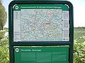 Public map showing a node network

.JPG)


So far, the cycle node network is pretty continuous, that means that you can cycle over province or even country boundaries without leaving the network. The style of the signs will change, but the routes blend together nicely. It also means that anyone in the Netherlands and Flanders now lives close to one of the nodes, so it's easy to just take your bike, cycle to the nearest node, and follow the network from there on.
The walking node networks are not continuous however. The walking node networks only exist in regions where it's interesting to walk. Some networks can cross a boundary (like the "Hoppeland - Pays du Houblon" network that's part in Belgium and part in France), but the networks only exist in regions that are attractive to walk in.
Disadvantages of the node network system
Of course, the system also has disadvantages. The main one is that the map can get outdated soon. When a new route is added to the mesh, it requires the creation of a new node between existing nodes, and thus users still have to consult a map when such a node is inserted, to see which way they should go.
This is mainly a disadvantage with paper maps, as they are quite expensive to update.
It's even worse than a missing sign on a regular walking route, as the next crossing on a regular route will normally still have the correct sign. While an entire stretch will be resigned with the node network system. So users definitely need to take a map with them.
Current tagging
The current tagging consists of three parts: tagging the nodes, tagging the routes and tagging the route network as a whole:
Nodes
rwn_ref=xx: This is the only tag used on nodes
Routes
Routes are mapped as a route relation with the following tags:
type=routeroute=cycling/hikingnetwork=rcn/rwn: the routes are tagged under the regional cycling or walking network because that network wasn't used otherwise in the Netherlands or Belgiumnote=xx-xx: A note is used to show the route refs in JOSM, this is the only way so far to be able to work with the routes, without disturbing the existing renderers
Route networks
Route networks are the combinations of routes that exist in a single network. This is more clear for hiking networks (where the networks are not or only barely connected to others), but for cycle networks this can be almost invisible on the ground.
type=networkname=Fietsroutenetwerk B Leiestreek: The name of the network (this is usually the name that can be found on the official map, and mentioned in a small font on the signsnetwork=rwn/rcn: repeating the network the individual routes belong tooperator=Toerisme West-Vlaanderen: the official instance operating the network (responsible for missing signs etc.)ref=WVl-LS: ref of the network
Problems with the current tagging
Usage of rwn and rcn network types
The usage of the rwn and rcn network types is the biggest issue currently. These networks don't exist in small countries like the Netherlands and Belgium (only local and national routes exist), but they do exist in big countries like Germany and France.
So these routes will start to get into the way of existing routes, and they will be hard to filter out based on tags.
The definition of a node
The node network uses nodes, but these nodes don't always match one-to-one with OSM nodes. Think of a roundabout: the official signs will consider the entire roundabout as one node in the network, but in the OSM data, there is at least one node per attached street. Sometimes crossings where the streets are not directly opposite of each other will also be handled as one node in the network, while they are two in OSM.
Forward and backward routes
Certainly when cycling, there can be a difference between forward and backward routes caused by oneway streets. These are currently tagged with the forward and backward roles, but these relations become hard to modify over time. When more cycleways are added, the routes will also become split more often. See 1514876![]() 1514876 as an example of such a split route caused by cycle lanes and oneway streets.
1514876 as an example of such a split route caused by cycle lanes and oneway streets.
Node tags
Normal POI have at least two tags, one showing the type (like amenity=restaurant) and one for the specific name or ref (like name=*). For the node network, both are put into one tag. This creates problems with some tools (where the icon depends on the complete tag rather than on a key), and it's also a problem for the mappers. F.e. when you know it's a node, but don't know the exact reference of the node (blurry photo, passed too quickly, ...), you can only put something cryptic like rwn_ref=XX, instead of a correct tag.
Uniqueness of a route between two nodes
This is more of a problem with the official system instead of with our tagging, but in some locations there are two different routes between the same nodes. These are not an immediate problem for the data (there will just be two routes with the same tags), but it will be a problem for the apps that work with the data. F.e. clicking on nodes to create a route will be a lot harder in that case.
Proposed new tagging
TODO: I'm still thinking about the best way to tag node networks. This info is by no way final.
For the proposed tagging, it's important that none of these tags are used before. We should also watch out that a single OSM node can be part of both the cycle node network and the walking node network, so the tags should not collide with each other.
Nodes
This tag can be used on OSM nodes and ways in order to solve the problem with roundabouts being considered a single network node.
tourism=cycling_node/walking_node: nodes that are part of both networks can use the regular ';' separator. Tools will need to take this into accountref:cnn=xx: the reference for the cycle node networkref:wnn=xx: the reference for the walking node network
Routes
TODO: check what is done with PT routes and use the same forward/backward system?
Route Networks
Tools using the current tagging schema
There are different tools using or working with the current tagging schema. If you know one, please add it to the list:
- Lonvia: Renders the walking and cycling node network.
- hikebikemap: Displays the networks, but uses lonvia's rendering
- OpenFietsKaart: Renders the cycle node network in the Netherlands and Flanders
- OpenWandelKaart: Renders the walking node network in the Netherlands and Flanders
- opencyclemap: Renders the cycle node network
- ...
Status
Although there has been no work on this proposal since 2015, it now looks like a de facto standard.
| Tag Usage (2022) | |||
|---|---|---|---|
lcn_ref=* |
12 438 | rcn_ref=* |
55 357 |
lhn_ref=* |
- | rhn_ref=* |
865 |
lin_ref=* |
- | rin_ref=* |
42 |
lmn_ref=* |
- | rmn_ref=* |
359 |
lpn_ref=* |
122 | rpn_ref=* |
56 |
lsn_ref=* |
110 | rsn_ref=* |
- |
lwn_ref=* |
467 | rwn_ref=* |
39 605 |
Discussion
Skiing

In Norway there are also node networks for cross country skiing, e.g. on Golsfjellet and Dagalifjellet. Also in Oregon or Sierra Nevada (USA) node networks are very popular, including for winter activities like snoshoe walking, fatbike riding or snowmobile driving. The proposal should be extended accordingly.
Alternate proposal: Named junction
It is established to use junction=* together with name=* for junctions with a name, cf. Named spots instead of street names. They are rendered as a text near to the junction.
Users in USA have proposed to use this for node networks too. You may find then a text like "Junction 57" near to the junction. Drawback is that there is no information about the type of activity, nor do you get the impression of a node network.