San Juan, Puerto Rico
| V・T・E |
| latitude: 18.45, longitude: -66.067 |
| Browse map of San Juan 18°27′00.00″ N, 66°04′01.20″ W |
| Edit map |
|
External links:
|
| Use this template for your locality |
San Juan is a city in Puerto Rico at latitude 18°27′00.00″ North, longitude 66°04′01.20″ West.
This page is for organizing and discussing mapping in San Juan, Puerto Rico.
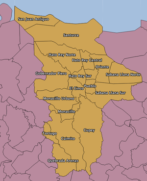
Districts of San Juan
San Juan is divided into 18 subdistricts (see wikipedia entry:

|
|
San Juan Antiguo (Old San Juan)
Old San Juan needs some work. Main tasks are:
- collect gpx tracks to ensure imagery alignment
- edit the TIGER imported roads, check for accuracy and remove tiger:reviewed=no tags; be sure to get the one-way streets down; also collecting surface type
- digitize buildings, with addr:street and addr:housenumber tags
- map POIs
- map landuse
Download Old San Juan Imagery ~650MB - See below for more info.
The first San Juan Mapping Party was held in Old San Juan on 9 February, 2014.
Santurce
Santurce is about the same as Old San Juan. Main tasks are:
- collect gpx tracks to ensure imagery alignment
- edit the TIGER imported roads, check for accuracy and remove tiger:reviewed=no tags; be sure to get the one-way streets down; also collecting surface type
- digitize buildings, with addr:street and addr:housenumber tags
- map POIs
- map landuse
Download Santurce Imagery ~3.8GB - See below for more info.
Imagery
There is public domain imagery available for all of Puerto Rico, which is far better than than the imagery available via Bing. It comes from the U.S. Army Corps of Engineers, collected around 2009-2010, metadata is here. It's not available yet as a web service (we need a place to host tiles), but some of the imagery has been rendered as mbtiles and is available for download. MBtiles can be opened as a layer in JOSM after installing the mbtiles plugin. Download links are in sections above.
Railroads
See Puerto Rico/Railroads' Passenger Rail section, Commuter (passenger=suburban) trains subsection for Tren Urbano. See United_States/Railways.
Mailing List
Puerto Rico mappers communicate via a mailing list. Join here.
Events
The first San Juan Mapping Party was held on February 9th, 2014. Join the mailing list to join future events!
