Square

|
| Description |
| A town or village square: a hardscaped open public space, generally of architectural significance, which is surrounded by buildings in a built-up area such as a city, town or village. |
| Group |
| Tags |
A town square or village square is a hardscaped open public space, generally of architectural significance, which is surrounded by buildings in a built-up area such as a city, town or village.
Also known as a city, urban, public or market square, most are paved surfaces suitable for open markets, concerts, political rallies, and other events that require a solid surface. They are often named and can be mapped as with place=square.
However, sometimes a named feature that includes the word "square" is more correctly considered a street or road junction (tagged junction=yes) or a park (leisure=park) if it is mostly vegetated.
Such features are known in many languages, e.g.: English: square, plaza; French: place; German: Platz; Italian: piazza, largo, piazzale, campo; Spanish: plaza; Russian: площадь, Chinese (simplified): 广场.
Tagging
The place=* key is used in OpenStreetMap to indicate that a particular location is known by a particular name, to indicate what sort of "place" it is. Thus, a square can be tagged with place=square. The simplest method is tagging a node, however when the outline of the place is verifiable, mapping as a polygon way is recommended.
A square can comprise different features, or consist just of one of them. These features include roads crossing or passing them, road junctions, pedestrian areas, parks, small green areas, memorials, fountains, etc.
Boundaries
Squares are different, and so are their boundaries. When a square is surrounded by buildings (that often have the square name as the address), the polygon should touch but not include the buildings. When a square is surrounded by streets having different names, the square polygon should be mapped within the streets.
When the square has the same boundaries as a vegetated park or a paved pedestrian area, the same polygon can be tagged as place=square and as leisure=park or highway=pedestrian+area=yes.
When the features the square consists of are sub-areas, the square polygon should be tagged as place=square and bearing the name=* tag, while the sub-areas like leisure=park or highway=pedestrian+area=yes would be mapped as separate polygons and not be named.
Gallery
(it would be helpful to add more images, in particular of a square purely used for a park, or purely as pedestrian area)
-
 Berlin, Leninplatz 1988
 -
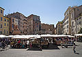 Campo dei Fiori
 -
 Piazza San Pietro


See also
highway=pedestrian+area=yes- a hard-surfaced, open pedestrian arealeisure=park- an urban park, mostly vegetated with grass, trees, shrubs and flowers, though there may also be significant paved areas.junction=yes- a junction of streets or roads, which may be namedplace=neighbourhood- a neighborhood surrounding a square, which may share the same nameamenity=marketplace- for a public market where goods and services are traded daily or weekly, often held in a "market square"landuse=village_green- a distinctive area of grassy public open land in a village centrearea:highway=pedestrian- an area representation of a linear pedestrian street (This tag is not normally used for squares)