Tag:utility=hydrant
Jump to navigation
Jump to search
| Description |
|---|
| Specific infrastructure dedicated to fire hydrant feeding with water from mains or pumping local network. |
| Group: man made |
| Used on these elements |
| Useful combination |
| Status: approved |
| Tools for this tag |
Beside main utility=water activity, you may find dedicated pipes to emergency=fire_hydrant feeding. This values is intended to make a difference between those two as it can be done on ground.
This value is only suitable for fire fighting devices pressurized or not.
This value was originally introduced to be used in combination with marker=* but sounds suitable on any feature directly involved in or dedicated to fire hydrants.
Examples
| Photo | Location | Tagging | Note |
|---|---|---|---|
 |
Germany | emergency=signmarker=plateutility=hydrant
|
A sample sign with tagging suggestion. |
 |
UK | marker=plateutility=hydrant
|
An old fire hydrant sign on the wall |
 |
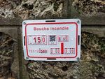
France | marker=plateutility=hydrantoperator=Eau de Parisref=751120563
|
Those plates are currently rolled out by Eau de Paris and gives several information about a near hydrant installed at stated distances from the marker. The hydrant is fed by water main of given diameter |