Tag:amenity=driver_training
(Redirected from Tag:amenity=driver training area)
 |
| Description |
|---|
| A place for driving training on a closed course. |
| Group: amenities |
| Used on these elements |
| Useful combination |
|
| See also |
| Status: in use |
| Tools for this tag |
Use amenity=driver_training to tag an area used for driving practice, such as for driving lessons on a closed course. In some Asian countries these are commonly found as dedicated training grounds of driving schools where part of the practical driving education consists of closed course training. In the west, they may be found as skid training courses.
How to map
Draw a closed area or place a node at the center of the area. The lanes within the area can be tagged with highway=service combined with access=private.
Rendering
It is rendered by OsmAnd and Tracestrack but not supported by Carto.
Examples
-
 Skid training
 -
![A driving school training ground in Tokyo]](https://upload.wikimedia.org/wikipedia/commons/thumb/4/44/Driving_School_in_Tokyo_%288982091%29..jpg/120px-Driving_School_in_Tokyo_%288982091%29..jpg) A driving school training ground in Tokyo]
A driving school training ground in Tokyo] -
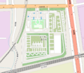 Tracestrack's render on driving_training

![A driving school training ground in Tokyo]](/wiki/File:Driving_School_in_Tokyo_(8982091)..jpg)

See also
highway=racewayamenity=driving_schoolamenity=traffic_parkfor children.