Tag:boundary=maritime
| Description |
|---|
| Maritime boundaries under the UN Convention on the Law of the Sea which are not administrative boundaries: the baseline, contiguous zone, and EEZ. |
| Group: boundaries |
| Used on these elements |
| Requires |
| Implies |
| Status: approved |
| Tools for this tag |
|
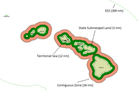
The tag boundary=maritime is used on several kinds of Maritime boundaries over areas of sea claimed by countries under the UN Convention on the Law of the Sea, which are not administrative boundaries. The main use is for mapping the baseline, contiguous zone, and EEZ (exclusive economic zone), distinguished with the tag with border_type=baseline:
- Baseline: boundary=maritime + border_type=baseline
- Contiguous zone: boundary=maritime + border_type=contiguous
- Exclusive economic zone (EEZ): boundary=maritime + border_type=eez
Territorial sea is marked differently:
- Territorial sea: boundary=administrative + maritime=yes + border_type=territorial + admin_level=2
Almost every non-landlocked country has maritime borders, national borders at sea. United Nations Convention on the Law of the Sea establishes that the territorial waters of a country can extend up to 12 nautical miles (22.224 kilometres) from the low-tide mark of the sea. This distance does not apply for all borders of this type: for instance, the English Channel is only 34 km at its narrowest point. In this situation, the national border lies along the midway line of the English Channel.
Maritime borders are frequently not fully closed, notably for the exclusive economic zone or the extension of the continental shelf (due to the absence of international agreement between two or more bordering countries). If some part of the EEZ is missing, the area is implicitly limited by the territorial waters and by the shortest segments joining each ending node of the EEZ to the territorial waters.
|
When you create a Relation:boundary for a maritime zone, please use the name=* tag for the name of the zone, i.e. as it appears in legal texts. Use a constructed name like name of the country (type of zone) only as a last resort, if the proper name of the zone itself is not known. |
Baseline
The baseline from which the territorial sea is measured is based on the low-water line along the coast. However, the baseline usually cuts in a straight line across the entrance of fjords, estuaries and gulfs, all navigational waters inside the baseline are defined as inshore or protected water. There are also straight baselines and archipelagic baselines which extend far out into the sea. In contrast, the natural=coastline should be placed at mean high water springs (MHWS) - the actual high tide line.
Contiguous zone (24 NM zone)
The contiguous zone is a band of water extending from the outer edge of the territorial sea to up to 24 nautical miles (44 km) from the baseline, within which a country can exert limited control.
- Potential data sources
- US [1]
Exclusive economic zone (EEZ) (200 NM zone)
An exclusive economic zone extends from the outer limit of the territorial sea to a maximum of 200 nautical miles (370 km) from the territorial sea baseline, thus it includes the contiguous zone. A coastal nation has control of all economic resources within its exclusive economic zone, including fishing, mining, oil exploration, and any pollution of those resources.
Territorial sea (12 NM zone)
A country's territorial sea is not tagged with boundary=maritime but with the usual tag for country borders: boundary=administrative. This line is usually 12 nautical miles (about 22 km) from the baseline. If this would overlap with another country's territorial sea, the border is usually the median between the countries' baselines. Some countries claim territorial sea up to 200 nautical miles but this does not meet the requirements of UNCLOS. There are also some other special cases like the territorial sea of the Philippines and other archipelagic countries.
- boundary=administrative - same as land-based administrative boundaries
- maritime=yes - to state that this is a maritime border, so it can be rendered correctly/different from land borders
- admin_level=2 - since it is a national boundary
- border_type=territorial - to distinguish it from borders on land
These ways should also be members of the boundary relation of the country.
- Potential data sources
- US: [4] (historical data: [5] [6])
- The UN provides a list with maritime claims
Boundary relations
National borders
The territorial waters line (12 NM zone) should be included in boundary=administrative relations, the same as land borders.
Internal borders
If a country has defined the maritime borders of sub-national entities, this way should be included in boundary relations for these entities.
In the United States, "The 9-nautical-mile Natural Resource Boundary off the Gulf coast of Florida, Texas, and Puerto Rico, and the Three Nautical Mile Line elsewhere remain ... the outer limit ... of the states."
Potential sources
- United Nations Laws of the Sea: The UN DOALOS have a database over all maritime border claims. There is no apparent license on the data and this is the borders definitions. But the database is a database of different PDF files with coordinates of baselines and territorial borders. The text has to be parsed by hand and other maritime borders needs to be calculated from the baseline (see maritime borders). Data is to be tagged with source=UNCLOS
- United Nations database of treaties: may be useful, but may not be free; the website terms of use imply non-commercial use, no redistribution and no derivative work. But there are many commercial maps that refer to the database as a source.
Viewing maritime boundaries in OSM
You can conveniently view a maritime zone if you create a Relation:boundary for it:
- You can search maritime zones by name using Nominatim, and then click on the search result to view it.
- You can use Overpass turbo to generate a clickable map of maritime zones (change the value of border_type to view other zones than EEZs).
See also
- Key=boundary (German)
- Original Proposal page

