Talk:Tag:boundary=maritime
IALA-B
Isn't it just "South-Korea" instead of "Korea"? --Cbm 09:23, 15 August 2009 (UTC)
- I need to check that up better, the last source I checked said only Korea without specifying North and/or South. If somebody have a source to verify wether North Korea is IALA-A or IALA-B, please update description corresponding. --Skippern 09:44, 15 August 2009 (UTC)
http://en.wikipedia.org/wiki/International_Association_of_Lighthouse_Authorities
http://en.wikipedia.org/wiki/Lateral_mark
http://www.encyclopedia.com/doc/1O225-IALAmaritimebuoyagesystem.html
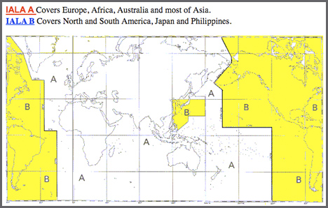
- Maybe this image could help: http://www.wsa-hamburg.wsv.de/schifffahrt/Schifffahrtszeichen/Bautechnik/iala/images/IALA_7001.gif --Cbm 21:54, 15 August 2009 (UTC)
- From that image I read that North Korea is IALA-A, maybe it is possible to find the treaty text somewhere to find it in writing? At least we can take a few waypoints out to draw the border of IALA-B americas. The treaty text should have a complete list of waypoints for this border. --Skippern 00:46, 16 August 2009 (UTC)
http://www.iala-aism.org/ <- Web site of IALA
- According to the Annex of IALA publication IALA Marine Bouyage System, IALA B are North, Central and South America, Japan, the Philipines, and Republic of Korea. North Korea is named Peoples Democratic Republic of Korea and South Korea is named Republic of Korea in these documents, i.e. North Korea is IALA A and South Korea is IALA B, will correct definition on front page accordingly. --Skippern 01:27, 16 August 2009 (UTC)
http://www.ialathree.org/iala/pages/publications/documentspdf/doc_24_eng.pdf page 4. there you can see the degrees where the border is --Cbm 00:13, 17 August 2009 (UTC)
it the daytime-border catched in OSM? It looks like that 25% of the IALA-B/-A borderline is the same. --Cbm 09:37, 16 August 2009 (UTC)
Territorial border
According to the UN resolution of maritime boundaries, the territorial waters goes to 12nm. Can somebody list countries that only uses 3nm for territorial border or refere to a document stating 3nm as territorial waters? IMO the (sometimes 3 nm) should be removed from the description of the tag. --Skippern 21:51, 5 September 2009 (UTC)
- Here are the list straight from the UN http://www.un.org/Depts/los/LEGISLATIONANDTREATIES/claims.htm --Gnonthgol 22:45, 7 February 2010 (UTC)
Role for territorial waters in national administrative boundary relation
What role should be used for a territorial waters way in an admin_level=2 national boundary relation? Mentor 00:10, 17 July 2010 (UTC)
- IMO the maritime borders in admin_level=2 should follow the same guideline as for borders on land. --Skippern 08:47, 18 August 2010 (BST)
PSSA
Should we make a boundary tag for Particularly Sensitive Sea Areas? I am at the moment working off the coast of Shetland, and all the sea around Shetland is marked as a PSSA. I am sure there are good datasources from IMO allowing for a complete import of PSSA. --Skippern 08:51, 18 August 2010 (BST)
More maritime boundary types
Various seafront nations have other maritime boundaries as well, in addition to the border types already mentioned. I am first of all thinking of Fishery Zone and Continental Shelf, both have some national specific properties (i.e. limit where you can fish without special vessel registration, etc) or special mentions in international treaties. Custom limit should probably be covered differently as free ports and tax free zones make this a patchwork. All three mentioned boundary types have separate INT 1 symbols. --Skippern 12:19, 7 October 2010 (BST)
Errors
Russia is missing many of its straight baselines: Full list of coordinates for the north and west . Coordinates for baselines in the east with illustrative maps
Vanatu has an archapelagic baseline system. Coordinates: Vanatu
Sao Tome and Principe have archapelagic baselines Map & coords
15:35, 22 March 2014 (UTC)
Name for the area
I see the name for this area is different across countries. What should be the name? I think the standard name should be included in english name:en like the following:
- Country Name - EEZ
AngocA (talk) 04:04, 10 November 2022 (UTC)
- Generally,
name=*should probably be the name of the zone as used in the legislation that declares the zone. Most countries typically submit (English) translations of this legislation to the UNCLOS website, which can help withname:en=*. - A fixed format like "Country Name - EEZ" is not used as an actual name for the zone and therefore does not belong in
name=*(except perhaps as a temporary placeholder until the proper name is determined). Nevertheless it is probably useful addcountry=*to clarify which country a zone belongs to, which data consumers could use to look up the corresponding country name. - --JeroenvanderGun (talk) 17:28, 10 November 2022 (UTC)
- Therefore, areas in Spanish should be something like: "name:es": "Zona Económica Exclusiva de Portugal" ? AngocA (talk) 15:51, 30 December 2022 (UTC)